Maps of Long Island

A map of the state of New Jersey: with part of the adjoining states / compiled under the patronage of the Legislature of said state by Thomas Gordon; engraved by H.S. Tanner, assisted by E.B. Dawson & W. Allen.
from Whole Thomas Gordon; Henry S. Tanner; E.B. Dawson; W. Allen,
New Jersey / engraved by J.H. Young.
from Whole J. H. Young,
New Jersey / engraved by J.H. Young.
from Whole J. H. Young,
New Jersey / engraved by A. Doolittle, Newhaven.; Carey's American pocket atlas; containing nineteen maps... with a brief description of each state.
from Carey's American pocket atlas; containing nineteen maps... with a brief description of each state. Carey, Mathew; Sweitzer, Henry,
Chart of Long Island Sound, 1822 / Hooker sc.
from The American coast pilot; containing the courses and distances between the principal harbours, capes, and headlands, on the coast of North and South America; with directions for sailing into the same ... with the prevailing winds, setting of the currents, &c., and the latitudes and longitudes of the principal harbours and capes. Together with a tide table. By Edmund M. Blunt. Cor. and improved by information derived from official documents, actual observations, and the most experienced pilots.
A New and accurate map of the present seat of war in North America: comprehending New Jersey, Philadelphia, Pensylvania, New-York, &c.
from Revolutionary War, 1775-1783 s.n.: [London],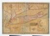
Map of Long Island with the environs of New-York and the southern part of Connecticut / compiled from various surveys & documents by J. Calvin Smith ; engraved & printed by S. Stiles & Co., N. York.
from Long Island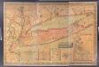
Map of Long Island with the environs of New-York and the southern part of Connecticut / compiled from various surveys & documents by J. Calvin Smith ; engraved & printed by S. Stiles & Co., N. York.
from Long Island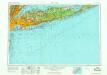
New York
1 : 250000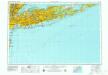
New York
1 : 250000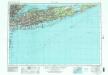
New York
1 : 250000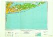
New York
1 : 250000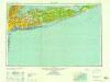
New York
1 : 250000
New York
1 : 250000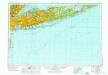
New York
1 : 250000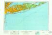
New York
1 : 250000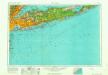
New York
1 : 250000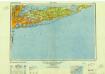
New York
1 : 250000
New York (City) & Vicinity.
1 : 400000 Asher & Adams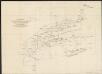
A diagram of the triangulation for the survey of the coast of the United States, made in 1817 and 1833, and the secondary triangles made in 1833 & 1834 in Connecticut & upon Long Island
1 : 412000 United States Coast Survey United States Coast Survey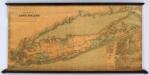
Colton's New Map Of Long Island.
1 : 126720 Colton, G.W.
Map of the county of Suffolk / by David H. Burr ; engd. by Rawdon Clark & Co., Albany, & Rawdon, Wright & Co., N. York.
from An atlas of the state of New York : containing a map of the state and of the several counties / by David H. Burr.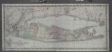
Map of Long Island and the southern part of Connecticut.
from Long Island
An accurate map of Staten Island : with that part of New York, Long Island and the Jerseys which is the rendesvous of the two grand armies and the supposed present seat of action / by a mercht. who resided in America 15 years.
from Whole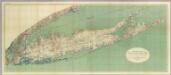
Map Of Long Island, New York.
1 : 125000 U.S. Geological Survey
Map of the county of Suffolk / by David H. Burr ; engd. by Rawdon Clark & Co., Albany, & Rawdon, Wright & Co., N. York.
from An atlas of the state of New York, designed for the use of engineers, containing a map of the state and of the several counties. / Projected and drawn ... under the superintendence and direction of Simeon de Witt.
Brooklyn land use policy
From The Borough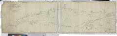
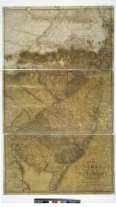
Long Island Sound from New York to Montock Point / surveyed in the years 1828, 29, & 30, by Edmund Blunt ; the writing by D.R. Harrison ; plan by W. Hooker ; W. Hooker, engraver & copper-plate printer, Franklin Hall, N.Y.
from Long Island
Map of the country thirty three miles around the city of New York / drawn by G.W. Colton ; engraved by J.M. Atwood, N.Y.
from Whole