Maps of Warmian-Masurian

Übersichtskarte von Mittel - Europa

Übersichtskarte von Mittel - Europa

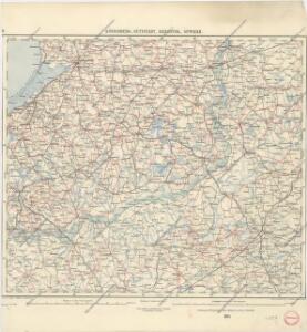
Königsberg, Guttstadt, Biełostok, Suwałki
1 : 750000 Białystok (Polsko : oblast) Konrad, Adalbert K. u. k. Militärgeographisches Institut
Königsberg, Guttstadt, Bielostok, Suwalki
1 : 750000 Białystok (Polsko : oblast) K. k. militär-geographisches Institut
Nr. 12. Die ersten Schlachten in Ostpreußen
Ostpreußen Weltkrieg <1914-1918>
Plan einer trigonometrischen Ausmessung welche in den Jahren 1796 und 1797 in Ostpreussen und Lithauen ausgeführt worden
1 : 800000 Landes-Industrie-Comptoir
Provinz Ost - Preussen


Provinz Ostpreussen
1 : 1250000 Ostpreußen
Ost-Preussen.
1 : 935000 Flemming, Carl
Schema Teatra kampanīi 1806-7 gg.
Polen Napoleonische Kriege
Prvssiae nova tabvla
1 : 1100000 Mollova mapová sbírka Merian, Matthäus Merian, Matthäus - dědici
Litauisch und Masurisch
Ostpreußen Litauisch, Masurisch
Sect. 11: Allenstein, uit: Geologische Karte des Deutschen Reichs in 27 Blaettern / [von] Richard Lepsius ; Red. von C. Vogel
1 : 500000 Annotatie: Blad 18 ontbreekt; Een aantal bladen op linnen; Een aantal bladen gereviseerd 1913-1914; Annotatie geografische gegevens: Met schaalstokken o.a. in kilometers; Legenda Carl Vogel 1828-1897 Gotha : Justus Perthes
Nr. 21a. Weitere Ergebnisse der Winterschlacht in Masuren
Masuren Weltkrieg <1914-1918>, Ostfront
Winterschlacht in Masuren
1 : 2000000 Masuren Schlacht, Weltkrieg <1914-1918>
Regni Borussiae Episcopatus Warmiensis Palatinatus Mariaeburgensis et Culmensis cum Territorio Dantiscano et Ichnographia Urbis Regiomontis].
Mollova mapová sbírka
Obwod Białostocki
Białystok-oblast (Polsko)
Sect. 5: Königsberg, uit: Geologische Karte des Deutschen Reichs in 27 Blaettern / [von] Richard Lepsius ; Red. von C. Vogel
1 : 500000 Annotatie: Blad 18 ontbreekt; Een aantal bladen op linnen; Een aantal bladen gereviseerd 1913-1914; Annotatie geografische gegevens: Met schaalstokken o.a. in kilometers; Legenda Carl Vogel 1828-1897 Gotha : Justus Perthes
Operationskarte
1 : 300000 Annotatie: Uit Bd. 4 van: Der Krieg von 1806 und 1807 / O. von Lettow-Vorbeck. - Berlin : Mittler, 1896; Fotogr. reprod. van origineel uit: Der Krieg von 1806 und 1807 ... / E. von Höpfner. - Berlin : Schropp, 1850 Berlin : Mittler

Schlacht an den Masurischen Seen
1 : 1000000 Masuren Schlacht, Weltkrieg <1914-1918>

29 Augustowo, uit: Special-Karte von Mittel-Europa / nach amtlichen Quellen bearbeitet von W. Liebenow
1 : 300000 titelvariant: W. Liebenow's Mittel-Europa; Annotatie: Titel boven de bladen: W. Liebenow's Mittel-Europa Johannes Wilhelm Liebenow 1822-1897 Frankfurt a. M. : Ludwig Ravenstein
Tabvla geographica episcopatvm Warmiensem in Prvssia exhibens, Heilsberg, solita habitatio episcopalis, longitudinem 38. graduum, et 16. minutorum ab insula Ferro numerat
1 : 220000 Lidzbark Warmiński-oblast (Polsko) Endersch, Johann Friedrich Grabowski, Adam Stanisław Ioannes Fridericus Endersch
Regni Borussiae Episcopatus Warmiensis Palatinatus Mariaeburgensis et Culmensis cum Territorio Dantiscano et Ichnographia Urbis Regiomontis].
Mollova mapová sbírka
28 Lötzen, uit: Special-Karte von Mittel-Europa / nach amtlichen Quellen bearbeitet von W. Liebenow
1 : 300000 titelvariant: W. Liebenow's Mittel-Europa; Annotatie: Titel boven de bladen: W. Liebenow's Mittel-Europa Johannes Wilhelm Liebenow 1822-1897 Frankfurt a. M. : Ludwig Ravenstein
Karte von Ermeland oder zweites Blat von Westpreussen
1 : 225000 Prusko Západní Endersch, Johann Friedrich Amon, Anton F.A. Schraembl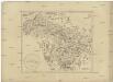
Karte von Ermeland oder zweites Blat von Westpreussen
1 : 225000 Prusko Západní Endersch, Johann Friedrich Amon, Anton F.A. Schraembl