Maps of powiat olsztyński

Tabvla geographica episcopatvm Warmiensem in Prvssia exhibens, Heilsberg, solita habitatio episcopalis, longitudinem 38. graduum, et 16. minutorum ab insula Ferro numerat
1 : 220000 Lidzbark Warmiński-oblast (Polsko) Endersch, Johann Friedrich Grabowski, Adam Stanisław Ioannes Fridericus Endersch
Operationskarte
1 : 300000 Annotatie: Uit Bd. 4 van: Der Krieg von 1806 und 1807 / O. von Lettow-Vorbeck. - Berlin : Mittler, 1896; Fotogr. reprod. van origineel uit: Der Krieg von 1806 und 1807 ... / E. von Höpfner. - Berlin : Schropp, 1850 Berlin : Mittler
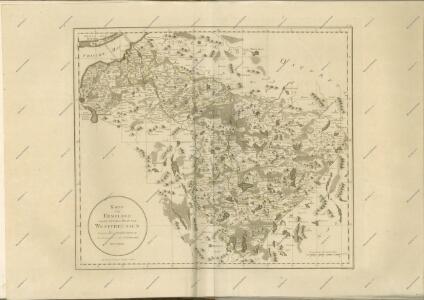
Karte von Ermeland oder zweites Blat von Westpreussen
1 : 225000 Prusko Západní Endersch, Johann Friedrich Amon, Anton F.A. Schraembl
Karte von Ermeland oder zweites Blat von Westpreussen
1 : 225000 Prusko Západní Endersch, Johann Friedrich Amon, Anton F.A. Schraembl
Karte von Ermeland oder zweites Blat von Westpreussen
1 : 225000 Prusko Západní Endersch, Johann Friedrich Amon, Anton F.A. Schraembl
Composite: 73. Heiligenbeil. (Germany)
1 : 100000 Reichsamt fur Landesaufnahme
Elbing 27, uit: Special-Karte von Mittel-Europa / nach amtlichen Quellen bearbeitet von W. Liebenow
1 : 300000 titelvariant: W. Liebenow's Mittel-Europa; Annotatie: Titel boven de bladen: W. Liebenow's Mittel-Europa Johannes Wilhelm Liebenow 1822-1897 Frankfurt a. M. : Ludwig Ravenstein
73. Heiligenbeil. (Germany)
1 : 100000 Reichsamt fur Landesaufnahme
Karte vom Kreise Rössel, Reg. Bez. Königsberg
Karte vom Kreise Rössel, Reg. Bez. Königsberg, gefestigt und herausgegeben von G. Schamberg's lithographischer Anstalt. Königsberg
Composite: 102. Wormditt. (Germany)
1 : 100000 Reichsamt fur Landesaufnahme
Composite: 133. Mohrungen. (Germany)
1 : 100000 Reichsamt fur Landesaufnahme
102. Wormditt. (Germany)
1 : 100000 Reichsamt fur Landesaufnahme
134. Allenstein. (Germany)
1 : 100000 Reichsamt fur Landesaufnahme
Composite: 167. Passenheim. (Germany)
1 : 100000 Reichsamt fur Landesaufnahme
Composite: 101. Elbing. (Germany)
1 : 100000 Reichsamt fur Landesaufnahme
Composite: 132. Christburg. (Germany)
1 : 100000 Reichsamt fur Landesaufnahme
165. Deutsch-Eylau. (Germany)
1 : 100000 Reichsamt fur Landesaufnahme
168. Ortelsburg. (Germany)
1 : 100000 Reichsamt fur Landesaufnahme
Sect. 14. Heiligenbeil, uit: Geologische Karte der Provinz Preussen
1 : 100000 Annotatie: Incompleet; Voor aanwezige bladen zie bladoverzicht; Met inzetkaarten; Annotatie geografische gegevens: Coördinaten gebaseerd op nulmeridiaan van Ferro (Hierro) Berlin : Neumann
Composite: 48. Gr. Bruch. (72. Frauenburg) (Germany)
1 : 100000 Reichsamt fur Landesaufnahme
167. Passenheim. (Germany)
1 : 100000 Reichsamt fur Landesaufnahme
103. Heilsberg. (Germany)
1 : 100000 Reichsamt fur Landesaufnahme
Composite: 134. Allenstein. (Germany)
1 : 100000 Reichsamt fur Landesaufnahme
Composite: 103. Heilsberg. (Germany)
1 : 100000 Reichsamt fur Landesaufnahme
132. Christburg. (Germany)
1 : 100000 Reichsamt fur Landesaufnahme
Plan zur Schlacht bei Heilsberg am 10. Juni 1807
1 : 25000 Annotatie: Uit Bd. 4 van: Der Krieg von 1806 und 1807 / O. von Lettow-Vorbeck. - Berlin : Mittler, 1896; Fotogr. reprod. van origineel uit: Der Krieg von 1806 und 1807 ... / E. von Höpfner. - Berlin : Schropp, 1850 Berlin : Mittler
Meßtischblatt 1096 : Ortelsburg, 1915
1 : 250000 Ortelsburg. - Aufn. 1912, hrsg. 1914, Auflagedr. 1915. - 1:25000. - [Berlin]: Reichsamt für Landesaufnahme, 1915. - 1 Kt.
Meßtischblatt 2491 : Ortelsburg (West), 1938
1 : 250000 Ortelsburg (West). - Hrsg. 1915, bericht. 1929, redakt. Änd. 1938. - 1:25000. - [Berlin]: Reichsamt für Landesaufnahme, 1938. - 1 Kt.