Maps of Podlachian

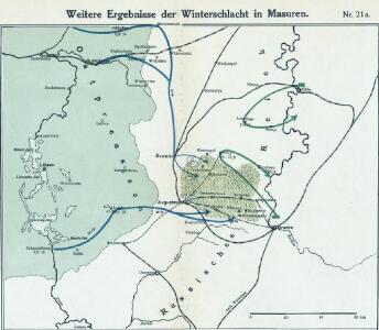
Nr. 21a. Weitere Ergebnisse der Winterschlacht in Masuren
Masuren Weltkrieg <1914-1918>, Ostfront
Winterschlacht in Masuren
1 : 2000000 Masuren Schlacht, Weltkrieg <1914-1918>
29 Augustowo, uit: Special-Karte von Mittel-Europa / nach amtlichen Quellen bearbeitet von W. Liebenow
1 : 300000 titelvariant: W. Liebenow's Mittel-Europa; Annotatie: Titel boven de bladen: W. Liebenow's Mittel-Europa Johannes Wilhelm Liebenow 1822-1897 Frankfurt a. M. : Ludwig Ravenstein
Suwalki 19, uit: Special-Karte von Mittel-Europa / nach amtlichen Quellen bearbeitet von W. Liebenow
1 : 300000 titelvariant: W. Liebenow's Mittel-Europa; Annotatie: Titel boven de bladen: W. Liebenow's Mittel-Europa Johannes Wilhelm Liebenow 1822-1897 Frankfurt a. M. : Ludwig Ravenstein
Schlacht an den Masurischen Seen
1 : 1000000 Masuren Schlacht, Weltkrieg <1914-1918>

Germany 1:100,000 , Series GSGS 2739, (Sheet 17E)
This map series of which this is part - Germany 1:100,000 , Series GSGS 2739 - are reproductions of German mapping with English marginalia. Great Britain. General Staff. Geographical Section. [London] : [GSGS, War Office]
Germany 1:100,000 , Series GSGS 2739, (Sheet 17D)
This map series of which this is part - Germany 1:100,000 , Series GSGS 2739 - are reproductions of German mapping with English marginalia. Great Britain. General Staff. Geographical Section. [London] : [GSGS, War Office]
Regni Borussiae Episcopatus Warmiensis Palatinatus Mariaeburgensis et Culmensis cum Territorio Dantiscano et Ichnographia Urbis Regiomontis].
Mollova mapová sbírka
77. Goldap. (Germany)
1 : 100000 Reichsamt fur Landesaufnahme
Composite: 77. Goldap. (Germany)
1 : 100000 Reichsamt fur Landesaufnahme
69. Friedrichshof, uit: Topographische Uebersichtskarte des Deutschen Reiches / herausgegeben v. d. Kartogr. Abt. d. Königl. Preuß. Landesaufnahme
1 : 200000 titelvariant: Topogr. Übersichtskarte des Deutschen Reiches; Annotatie: Titel boven bladen ook: Topogr. Übersichtskarte des Deutschen Reiches; Annotatie geografische gegevens: Op elk blad twee maatstokken: 10 Kilometer = 5,5 cm; 1 geogr. Meile = 3,6 cm; Legenda onder op elk blad Königlich Preußische Landesaufnahme. Kartographische Abtheilung [S.l : Königlich Preußische Landesaufnahme, Kartographische Abtheilung]
Plan de la bataille de Jaegerndorf
Schley, Jacobus van der Hondt, Pierre de Pierre de Hondt
Plan der bey Gross-Jägerndorf, den 30 Augusti A.o 1757 zwischen denen kayser. russischen und könig. preussischen Armeen vorgefallen Bataille
auf Kosten der Raspischen Buchhandlung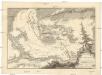
Bataille de Gros-Jaegerndorf, en Prusse, gagnée par l'armée russe, aux ordres du feldmaréchal d'Apraxin, sur les troupes prussienes commandées par le feldmaréchal de Lewald, le 30. aout, 1757
1 : 40000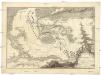
Bataille de Gros-Jaegerndorf, en Prusse, gagnée par l'armée russe, aux ordres du feldmaréchal d'Apraxin, sur les troupes prussienes commandées par le feldmaréchal de Lewald, le 30. aout, 1757
1 : 40000
Sect. 16. Nordenburg (Das alte Land Barten), uit: Geologische Karte der Provinz Preussen
1 : 100000 Annotatie: Incompleet; Voor aanwezige bladen zie bladoverzicht; Met inzetkaarten; Annotatie geografische gegevens: Coördinaten gebaseerd op nulmeridiaan van Ferro (Hierro) Berlin : Neumann
Sect. 17. Gumbinnen-Goldapp (Nord-Sudauen. Jetzt Littauen), uit: Geologische Karte der Provinz Preussen
1 : 100000 Annotatie: Incompleet; Voor aanwezige bladen zie bladoverzicht; Met inzetkaarten; Annotatie geografische gegevens: Coördinaten gebaseerd op nulmeridiaan van Ferro (Hierro) Berlin : Neumann
170.1. Bialla (202. Gehsen). (Germany)
1 : 100000 Reichsamt fur Landesaufnahme
53. Gumbinnen. (Germany)
1 : 100000 Reichsamt fur Landesaufnahme
202.1. (170. Bialla). Gehsen. (Germany)
1 : 100000 Reichsamt fur Landesaufnahme
54. Stalluponen. (Germany)
1 : 100000 Reichsamt fur Landesaufnahme
Composite: 106. Grabowen. (Germany)
1 : 100000 Reichsamt fur Landesaufnahme
Composite: 170.1. Bialla (202. Gehsen) (Germany)
1 : 100000 Reichsamt fur Landesaufnahme
Composite: 78. Mehlkehmen. (Germany)
1 : 100000 Reichsamt fur Landesaufnahme
78. Mehlkehmen. (Germany)
1 : 100000 Reichsamt fur Landesaufnahme
Composite: 202.1. (170. Bialla). Gehsen. (Germany)
1 : 100000 Reichsamt fur Landesaufnahme
Composite: 138. Lyck. (Germany)
1 : 100000 Reichsamt fur Landesaufnahme