Maps of powiat ełcki

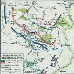
Schlacht an den Masurischen Seen
1 : 1000000 Masuren Schlacht, Weltkrieg <1914-1918>
Germany 1:100,000 , Series GSGS 2739, (Sheet 17D)
This map series of which this is part - Germany 1:100,000 , Series GSGS 2739 - are reproductions of German mapping with English marginalia. Great Britain. General Staff. Geographical Section. [London] : [GSGS, War Office]
Sect. 16. Nordenburg (Das alte Land Barten), uit: Geologische Karte der Provinz Preussen
1 : 100000 Annotatie: Incompleet; Voor aanwezige bladen zie bladoverzicht; Met inzetkaarten; Annotatie geografische gegevens: Coördinaten gebaseerd op nulmeridiaan van Ferro (Hierro) Berlin : Neumann
Sect. 17. Gumbinnen-Goldapp (Nord-Sudauen. Jetzt Littauen), uit: Geologische Karte der Provinz Preussen
1 : 100000 Annotatie: Incompleet; Voor aanwezige bladen zie bladoverzicht; Met inzetkaarten; Annotatie geografische gegevens: Coördinaten gebaseerd op nulmeridiaan van Ferro (Hierro) Berlin : Neumann
77. Goldap. (Germany)
1 : 100000 Reichsamt fur Landesaufnahme
Composite: 106. Grabowen. (Germany)
1 : 100000 Reichsamt fur Landesaufnahme
Composite: 77. Goldap. (Germany)
1 : 100000 Reichsamt fur Landesaufnahme
76. Nordenburg. (Germany)
1 : 100000 Reichsamt fur Landesaufnahme
137. Arys. (Germany)
1 : 100000 Reichsamt fur Landesaufnahme
136. Nikolaiken. (Germany)
1 : 100000 Reichsamt fur Landesaufnahme
Composite: 137. Arys. (Germany)
1 : 100000 Reichsamt fur Landesaufnahme
105. Rastenburg. (Germany)
1 : 100000 Reichsamt fur Landesaufnahme
Composite: 136. Nikolaiken. (Germany)
1 : 100000 Reichsamt fur Landesaufnahme
Composite: 76. Nordenburg. (Germany)
1 : 100000 Reichsamt fur Landesaufnahme
Germany 1:100,000 , Series GSGS 2739, (Sheet 17E)
This map series of which this is part - Germany 1:100,000 , Series GSGS 2739 - are reproductions of German mapping with English marginalia. Great Britain. General Staff. Geographical Section. [London] : [GSGS, War Office]
Composite: 78. Mehlkehmen. (Germany)
1 : 100000 Reichsamt fur Landesaufnahme
78. Mehlkehmen. (Germany)
1 : 100000 Reichsamt fur Landesaufnahme
Composite: 138. Lyck. (Germany)
1 : 100000 Reichsamt fur Landesaufnahme
53. Gumbinnen. (Germany)
1 : 100000 Reichsamt fur Landesaufnahme
54. Stalluponen. (Germany)
1 : 100000 Reichsamt fur Landesaufnahme
170.1. Bialla (202. Gehsen). (Germany)
1 : 100000 Reichsamt fur Landesaufnahme
Composite: 105. Rastenburg. (Germany)
1 : 100000 Reichsamt fur Landesaufnahme
138. Lyck. (Germany)
1 : 100000 Reichsamt fur Landesaufnahme
107. Marggrabowa. (Germany)
1 : 100000 Reichsamt fur Landesaufnahme
Plan de la Bataille de Jaegerndorf
Mollova mapová sbírka Oebschelwitz, L. W. von Hondt, Pierre de
Composite: 107. Marggrabowa. (Germany)
1 : 100000 Reichsamt fur Landesaufnahme
Entwurff des von der russisch-kays. Armee unter anführung des F. Marsch. Graff. von Apraxin den 30 Augusti 1757 über die könig. preüs. Armee erfochtenen herrlichen Siegs
Kaliningrad-oblast (Rusko) Marinville, de Salzer, Ignác
135. Sensburg. (Germany)
1 : 100000 Reichsamt fur Landesaufnahme
Meßtischblatt 22101/23101 : Kölmersdorf, 1938
1 : 250000 Kölmersdorf. - Hrsg. 1912, bericht. 1925, redakt. Änd. 1938. - 1:25000. - [Berlin]: Reichsamt für Landesaufnahme, 1938. - 1 Kt.