Maps of Czech Republic

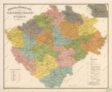
Übersichtts und Distanzen - Karte des k.k. Landes - Gendarmerie-Commando No 2 für Böhmen

Landtagswahlkarte von Böhmen nach dem Stande vom Sommer 1890
Sedlak, Karl
Nejnovější podrobná mapa Čech
1 : 400000 Praha (Česko) Štumper, Karel Šolc a Šimáček
[Čechy]
1 : 600000 Česko
Čechy, mapa isogon pro epochu 1925.5, Zěmě Moravsko - Slezská, mapa Isogon
Das chartografische Netz der ombrometrischen Stationen Böhmens
1 : 600000 Čechy (Česko) Purkyně, Emanuel Hickmann, Anton L. böhm. Forstverein
Mapa školství Království českého
1 : 460000 Čechy (Česko) Mařatka, František Zemský ústřední spolek jednot učitelských v Král. českém
Historická mapa Čech
1 : 525000 Česko Palacký, František Kalausek, Josef nákladem Kr. č. učené společnosti
Historická mapa Čech
1 : 525000 Česko Palacký, František Kalousek, Josef nákladem Kr. č. učené společnosti
Entwurf einer Uibersicht der neuen Entheilung der Kronlandes Böhmen
Čechy (Česko) Stifter, Johann Steyrer, Fr. C. Fr.C. Steyrer
Reisekarte des Königreiches Böhmen
1 : 600000 Bílina (Česko : oblast) Wagner, Jan Eduard Mareš, František F. Kytka
Mapa škol Království českého
Hradec Králové (Česko) Mařatka, František nákladem literárního odboru Ústředního spolku
Mapa škol Království českého
Hradec Králové (Česko) Mařatka, František Otto, Jan J. Otto
Geologická mapa Království Českého

Mapa příruční Království českého
1 : 600000 Česko Kocen, Blaž Erben, Josef sklad Eduarda Hölzela
Mapa příruční Království českého
1 : 600000 Čechy (Česko) Kocen, Blaž Erben, Josef sklad Eduarda Hölzela
Mapa příruční Království českého
1 : 600000 Česko Kocen, Blaž Erben, Josef sklad Ed. Hölzela
Karten zur Statistik des Königreiches Böhmen...

Karten zur Statistik des Königreiches Böhmen...

Geonomická mapa Čech

Neueste Reisekarte von Böhmen
1 : 600000 Česko Wagner, Jan Eduard F. Kytka
Statistisch topographische Karte des Kronlandes Boehmen
1 : 800000 Německo Steingruber, Konrad Riedl, Johann Baptist Joh. Stiasny
Bez titulu: Statistické mapky Čech

Uibersichts-Karte der Rübenzuckerfabricken in Böhmen
1 : 910000 Česko Friedrich, Ernst Koráb, Emil
Uebersichts-Karte der Rübenzucker-Production im Königreiche Böhmen
Evropa Bernat, Josef Statist. úřad pro království České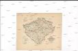
Karte über den industriellen Betrieb mit Metallen im Königreiche Böhmen
1 : 840000 Česko Hickmann, Anton L. Heinrich Mercy
Karte über den industriellen Betrieb mit Nicht-metallischen-Mineralien so wie über das Fluss-Strassen-Eisenbahn & Telegrafennetz des Königreiches Böhmen
1 : 840000 Česko Hickmann, Anton L. Heinrich Mercy
Karte über die Leinen-Waaren-Jndustrie im Königreiche Böhmen
1 : 840000 Česko Hickmann, Anton L. Heinrich Mercy
Karten zur Statistik des Königreiches Böhmen...