Maps of Czech Republic

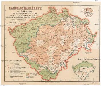
Landtagswahlkarte von Böhmen nach dem Stande vom Sommer 1890
Sedlak, Karl
Mapa školství Království českého
1 : 460000 Čechy (Česko) Mařatka, František Zemský ústřední spolek jednot učitelských v Král. českém
Karten zur Statistik des Königreiches Böhmen...

Bez titulu: Statistické mapky Čech

Čechy, mapa isogon pro epochu 1925.5, Zěmě Moravsko - Slezská, mapa Isogon
Fischerei-Karte des Königreiches Böhmen
České království Frič, Antonín Subvention des Landtages und des Comités für Landesdurchforschung
Fischerei-Karte des Königreiches Böhmen
Česko Frič, Antonín vydána pomocí sl. sněmu a komitétu pro výzkum Čech
Karten zur Statistik des Königreiches Böhmen

Mapa Království českého
1 : 500000 Čechy (Česko) z uměleckého závodu Eduarda Hölzela
Uebersichts-Karte über die Verbreitung der Spar- und Darlehenscassen-Vereine, landw. Lagerhäuser, und Molkerei-Genossenschaften im deutschen Sprachgebiete Böhmens
Sudety (Česko) A. Haase
Uibersichts-Karte der Rübenzuckerfabricken in Böhmen
1 : 910000 Česko Friedrich, Ernst Koráb, Emil
Uebersichts-Karte der Rübenzucker-Production im Königreiche Böhmen
Evropa Bernat, Josef Statist. úřad pro království České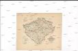
Karte über den industriellen Betrieb mit Metallen im Königreiche Böhmen
1 : 840000 Česko Hickmann, Anton L. Heinrich Mercy
Karte über den industriellen Betrieb mit Nicht-metallischen-Mineralien so wie über das Fluss-Strassen-Eisenbahn & Telegrafennetz des Königreiches Böhmen
1 : 840000 Česko Hickmann, Anton L. Heinrich Mercy
Karte über die Leinen-Waaren-Jndustrie im Königreiche Böhmen
1 : 840000 Česko Hickmann, Anton L. Heinrich Mercy
Nejnovější podrobná mapa Čech
1 : 400000 Praha (Česko) Štumper, Karel Šolc a Šimáček
Karte der Kreisgerichts-Sprengel und Gerichts-Bezirke des Königreiches Böhmen
1 : 600000 Čechy (Česko) Hickmann, Anton L. von A.L. Hickmann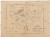
Übersichtskarte der Kohlenformationen und Eisenbahnen in Böhmen
Duchcov-oblast (Česko)
Übersichtskarte der Gebiete für die landwirthschaftlichen Regional-Ausstellungen in Boehmen
Čechy (Česko) von der k.k. patriotisch-oekonomischen Gesellschaft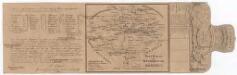
Post Karte vom Königreiche Böhmen
Čechy (Česko) Eckert, F. Sartorius, Johann Christoph
Historická mapa Čech
1 : 525000 Česko Palacký, František Kalausek, Josef nákladem Kr. č. učené společnosti
Historická mapa Čech
1 : 525000 Česko Palacký, František Kalousek, Josef nákladem Kr. č. učené společnosti
Karte des Königreiches Böhmen

Bohemia
1 : 750000 Sudety (Česko)
Bohemia
1 : 750000 Sudety (Česko)
Přehledná mapa pokračovacích škol průmyslových, kupeckých a j. v Království českém
Česko c. a k. dvorní litografie A. Haase
Geologická mapa Království Českého

Mapa škol Království českého
Hradec Králové (Česko) Mařatka, František nákladem literárního odboru Ústředního spolku
Mapa škol Království českého
Hradec Králové (Česko) Mařatka, František Otto, Jan J. Otto