Maps of Czech Republic

Bez titulu: Statistické mapky Čech
Übersichtskarte der Kohlenformationen und Eisenbahnen in Böhmen
Duchcov-oblast (Česko)
Čechy
1 : 1000000 Česko Ústřední nakladatelství a knihkupectví učitelstva československého
General-Karte von Böhmen
1 : 500000 Česko R. Lechner (Wilh. Müller)
General-Karte von Böhmen
1 : 500000 Česko R. Lechner (Wilh. Müller)
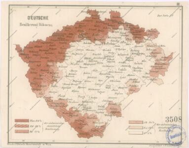
Karte der Bevölkerungsdichte (relative Bevölkerung) des Königreiches Böhmen
1 : 600000 Česko Hickmann, Anton L. A.L. Hickmann
Geologická mapa Království Českého

Historická mapa Čech
1 : 525000 Česko Palacký, František Kalausek, Josef nákladem Kr. č. učené společnosti
Historická mapa Čech
1 : 525000 Česko Palacký, František Kalousek, Josef nákladem Kr. č. učené společnosti
Isochronická mapa Čech
1 : 750000 Česko Nový, Václav Václav Nový
Isochronická mapa Čech
1 : 750000 Česko Nový, Václav Klub českých turistů
Karte der Kreisgerichts-Sprengel und Gerichts-Bezirke des Königreiches Böhmen
1 : 600000 Čechy (Česko) Hickmann, Anton L. von A.L. Hickmann
Übersichtskarte der Gebiete für die landwirthschaftlichen Regional-Ausstellungen in Boehmen
Čechy (Česko) von der k.k. patriotisch-oekonomischen Gesellschaft
Post Karte vom Königreiche Böhmen
Čechy (Česko) Eckert, F. Sartorius, Johann Christoph
Böhmen

Čechy
1 : 500000 Čechy (Česko) Havránek, J. E. Fastr
Bohemia
1 : 750000 Sudety (Česko)
Bohemia
1 : 750000 Sudety (Česko)
Mapa výšek s vrstvami Království českého
Čechy (Česko) Kořistka, Karel František Edvard Kapras, Jan nákladem J. Otty
Mapa výšek s vrstvami Království českého
Čechy (Česko) Kořistka, Karel František Edvard nákladem J. Otty
Mapa výšek s vrstvami Království českého
Čechy (Česko) Kořistka, Karel František Edvard
Mapa výšek s vrstvami Království českého
Čechy (Česko) Kořistka, Karel František Edvard nákladem J. Otty
Karte des oesterreichischen Kronlandes Böhmen
Čechy (Česko) Adam, Jakob Friedr. Kretzschmar
Karte des oesterreichischen Kronlandes Böhmen
Čechy (Česko) Fils Kretzschmar, Friedrich Friedr. Kretzschmar
Neueste Reisekarte von Böhmen
1 : 600000 Česko Wagner, Jan Eduard F. Kytka
Statistisch topographische Karte des Kronlandes Boehmen
1 : 800000 Německo Steingruber, Konrad Riedl, Johann Baptist Joh. Stiasny
Mapa školství Království českého
1 : 460000 Čechy (Česko) Mařatka, František Zemský ústřední spolek jednot učitelských v Král. českém
Vodopisná mapka Čech
1 : 902000 Česko
Karten zur Statistik des Königreiches Böhmen