Maps of Czech Republic

Přehledná mapa pokračovacích škol průmyslových, kupeckých a j. v Království českém
Česko c. a k. dvorní litografie A. Haase
Mapa Království českého
1 : 500000 Čechy (Česko) z uměleckého závodu Eduarda Hölzela
Rozdělení okresů školních v Království Českém

Mapa poštovních spojů v Čechách
1 : 400000 Pardubice (Česko : oblast) Ministerstvo pošt a telegrafů
Mapa poštovních spojů v Čechách
1 : 400000 Česko Pachman, Josef Ministerstvo pošt a telegrafů
Přehledná mapa železniční Království českého
1 : 600000 Česko Zemský výbor
Přehledná mapa železniční Království českého
Česko Zemský výbor
Železniční a silniční mapa Království Českého
1 : 525000 Česko Wagner, Jan Eduard F. Kytka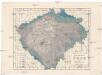
Dešťopisná mapa Čech
Čechy (Česko) Studnička, František Josef Langweil, Antonín
Dešťopisná mapa Čech
Čechy (Česko) Studnička, František Josef
Vodní mapa Čech se sití [sic] železniční
1 : 374000 Česko Mayr, Jos. Spolek českých lesníků
Statistisch topographische Finanz-Karte des Königreiches Boehmen
1 : 421500 Čechy (Česko) Herz, Johann Kübeck zu Kübau, Carl Friedrich bei Gottlieb Haase Sohne
Karten zur Statistik des Königreiches Böhmen...

Příruční mapa Království českého
1 : 600000 Česko Wagner, Jan Eduard F. Kytka
Králowstwj české
Česko Wondra, Jos. Havlík, H.
Království české
1 : 570000 Česko Wagner, Jan Eduard Jan Ed. Wagner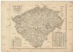
Království české
1 : 570000 Česko Wagner, Jan Eduard Jan Ed. Wagner
Království české
1 : 570000 Česko Wagner, Jan Eduard Jan Ed. Wagner
Království české
1 : 570000 Česko Wagner, Jan Eduard Jan Ed. Wagner
Karte des Königreich's Boehmen
1 : 415000 Česko Friedrich Kretzschmar
Mapa Králowstwj českého
1 : 740000 Čechy (Česko) David, Martin Alois Berka, Jan Nepomuk nákladem p. p. Benesse Jana Nepom. Pfeifera
Mapa Králowstwj českého
1 : 740000 Česko David, Martin Alois Berka Jan Nepomuk nákladem p. p. Benesse Jana Nepom. Pfeifera
Böhmen

Čechy
1 : 500000 Čechy (Česko) Havránek, J. E. Fastr
Království české
Česko Šrámek, Ferdinand
Království české
Česko Šrámek, Ferdinand
Království české
Čechy (Česko) Klub národní strany svobodomyslné
Království české
Česko Klub národní strany svobodomyslné
Schulkarte des Königreiches Böhmen
Česko F. Fischer
Isochronická mapa Čech
1 : 750000 Čechy (Česko) Nový, Václav


