Maps of Czech Republic

Isochronická mapa Čech
1 : 750000 Čechy (Česko) Nový, Václav
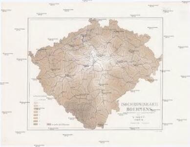
Isochronenkarte Boehmens
1 : 750000 Čechy (Česko) Nový, Václav
Království české
1 : 570000 Česko Wagner, Jan Eduard Jan Ed. Wagner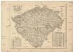
Království české
1 : 570000 Česko Wagner, Jan Eduard Jan Ed. Wagner
Království české
1 : 570000 Česko Wagner, Jan Eduard Jan Ed. Wagner
Království české
1 : 570000 Česko Wagner, Jan Eduard Jan Ed. Wagner
Karte des Königreich's Boehmen
1 : 415000 Česko Friedrich Kretzschmar
Neueste General Post

Školní závěsná mapa Království českého
1 : 288000 Česko Křížek, Václav v komisi Karla Janského
Království české
Česko Schlieben Ausfeld, Johann Carl sklad a tisk F. Líbiše
Čechy
1 : 500000 Čechy (Česko) Havránek, J. E. Fastr
[Soudní okresy Čech]
1 : 500000 Česko
[Soudní okresy Čech]
1 : 1000000 Česko
[Soudní okresy Čech]
1 : 750000 Česko
Topographisch-statistische Post und Strassenkarte des Königreiches Boehmen nach der neuen politischen Eintheilung
1 : 400000 Praha (Česko) Anděl, Bedřich bei Marco Berra
Das Königreich Böhmen
1 : 725000 Česko K. André
Das Königreich Böhmen
1 : 725000 Česko K. André
General-Karte des Königreiches Böhmen
1 : 378000 Čechy (Česko) Kořistka, Karel František Edvard Sommer, Adolf Eduard Hölzel's Verlag
Karte von Böhmen
1 : 518400 Česko
Příruční mapa Království českého
1 : 600000 Česko Wagner, Jan Eduard F. Kytka
Králowstwj české
Česko Wondra, Jos. Havlík, H.
Království české
Česko Šrámek, Ferdinand
Království české
Česko Šrámek, Ferdinand
Království české
Čechy (Česko) Klub národní strany svobodomyslné
Království české
Česko Klub národní strany svobodomyslné
Skelett für die Special-Karte des Königreich's Böhmen
Česko K. u. k. Militärgeographisches Institut
Post-Charte vom Königreiche Böheim
1 : 925000 Česko Kreibich, František Jakub Jindřich Rainold, Karl Eduard C.E. Rainold
Post-Charte vom Königreiche Böheim
1 : 925000 Česko Kreibich, František Jakub Jindřich Rainold, Karl Eduard C.E. Rainold
Post-Charte vom Königreiche Böheim
1 : 925000 Česko Kreibich, František Jakub Jindřich Rainold, Karl Eduard C.E. Rainold
Post-Charte vom Königreiche Böheim
1 : 925000 Česko Kreibich, František Jakub Jindřich Rainold, Karl Eduard C.E. Rainold