Maps of Czech Republic

Příruční mapa Království českého
1 : 600000 Česko Wagner, Jan Eduard F. Kytka
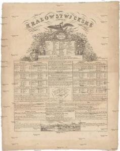
Králowstwj české
Česko Wondra, Jos. Havlík, H.
Království české
1 : 570000 Česko Wagner, Jan Eduard Jan Ed. Wagner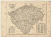
Království české
1 : 570000 Česko Wagner, Jan Eduard Jan Ed. Wagner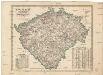
Království české
1 : 570000 Česko Wagner, Jan Eduard Jan Ed. Wagner
Království české
1 : 570000 Česko Wagner, Jan Eduard Jan Ed. Wagner
Karte des Königreich's Boehmen
1 : 415000 Česko Friedrich Kretzschmar
Isochronická mapa Čech
1 : 750000 Čechy (Česko) Nový, Václav
Isochronenkarte Boehmens
1 : 750000 Čechy (Česko) Nový, Václav
Karte der confessionellen Verhältnisse des Königreiches Böhmen
1 : 600000 Čechy (Česko) Hickmann, Anton L. A.L. Hickmann
[Soudní okresy Čech]
1 : 500000 Česko
[Soudní okresy Čech]
1 : 1000000 Česko
[Soudní okresy Čech]
1 : 750000 Česko
[Čechy]
1 : 600000 Čechy (Česko)
Karte von Böhmen
1 : 518400 Česko
Neueste General Post

Nejnovější příruční mapa Království Českého

Čechy
1 : 500000 Čechy (Česko) Havránek, J. E. Fastr
Školní závěsná mapa Království českého
1 : 288000 Česko Křížek, Václav v komisi Karla Janského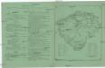
Království české
Česko Schlieben Ausfeld, Johann Carl sklad a tisk F. Líbiše
Isochronická mapa Čech

Topographisch-statistische Post und Strassenkarte des Königreiches Boehmen nach der neuen politischen Eintheilung
1 : 400000 Praha (Česko) Anděl, Bedřich bei Marco Berra
Schulkarte des Königreiches Böhmen
Česko F. Fischer
Sněhová pokrývka v Čechách v zimě 1906-1907
Čechy (Česko) Augustin, František Lhota, J. nákladem České společnosti zeměvědné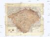
Hydrographische Übersichtskarte des Elbe-Gebietes und des in Böhmen gelegenen Oder-Gebietes
1 : 750000 Labe (Česko a Německo : řeka : povodí) k.k. hydrographisches Central-Bureau
Hydrographische Übersichtskarte des Elbe-Gebietes und des in Böhmen gelegenen Oder-Gebietes
1 : 750000 Labe-povodí (Česko a Německo) k.k. hydrographisches Central-Bureau
Přehledná geologická mapa Království českého
Čechy (Česko) Počta, Filip Lhota, J. nákladem J. Otty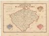
Sanitäts-Carte des Königreiches Böhmen
1 : 606000 Čechy (Česko) Antony, Karl Karl Antony
Entwurf einer statistischen Karte der Maulbeerbaumpflanzungen in Böhmen nach Daten der Bezirksvertrettungen
Čechy (Česko) Patzak, Julius Čeněk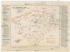
Karte der Wahlkreiseinteilung in Böhmen.
Čechy (Česko) Urban, Karl Lhota, J.
Böhmen
Čechy (Česko)