Maps of Czech Republic
Das chartografische Netz der ombrometrischen Stationen Böhmens
1 : 600000 Čechy (Česko) Purkyně, Emanuel Hickmann, Anton L. böhm. Forstverein
Nejnovější podrobná mapa Čech
1 : 400000 Praha (Česko) Štumper, Karel Šolc a Šimáček
Neueste Reisekarte von Böhmen
1 : 600000 Česko Wagner, Jan Eduard F. Kytka
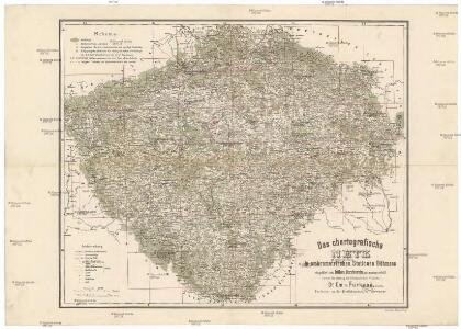
Statistisch topographische Karte des Kronlandes Boehmen
1 : 800000 Německo Steingruber, Konrad Riedl, Johann Baptist Joh. Stiasny
Národnostní mapa Království českého
Čechy (Česko) Waraus, E. Wagner, Jan Eduard F. Kytka
Politická a místopisná mapa Království českého
1 : 418000 Česko Erben, Josef nákladem kněhkupectví K. Janského
Politická a místopisná mapa Království českého
1 : 418000 Česko Erben, Josef Smolík, Ott. nákladem kněhkupectví K. Janského
Politická a místopisná mapa Království českého
1 : 418000 Česko Erben, Josef Smolík, Ott. nákladem kněhkupectví K. Janského
General-Uibersichts-Karte des Königreiches Böhmen
1 : 575000 Česko Windisch-Graetz, Alfred Kandidus C. Hennig u. F. Tempsky
General-Uibersichts-Karte des Königreiches Böhmen
1 : 575000 Česko Windisch-Graetz, Alfred Kandidus C. Hennig u. F. Tempsky
Strassen-Uebersichtskarte von Böhmen
1 : 665000 Česko
Strassen-Uebersichtskarte von Böhmen
1 : 665000 Česko
Strassen- Uibersichts- und Militair-Routen-Karte des Königreichs Böhmen
1 : 580000 Česko Windisch-Graetz, Alfred Kandidus Marco Berra
Nejnovější příruční mapa Království Českého

Reisekarte des Königreiches Böhmen
1 : 600000 Bílina (Česko : oblast) Wagner, Jan Eduard Mareš, František F. Kytka
Topographisch statistische Post und Strassenkarte des Königreiches Boehmen

Karten zur Statistik des Königreiches Böhmen...

[Čechy]
1 : 600000 Česko
Böhmen

Isochronická mapa Čech
General-Post & Strassen Karte des Königreichs Boehmen
1 : 642000 Čechy (Česko) Fried, Franz Artaria
Land Böhmen
1 : 1000000 Most (Česko : oblast) Paul Sollors' Nachf.
Geologická mapa Království Českého

Mapa příruční Království českého
1 : 600000 Česko Kocen, Blaž Erben, Josef sklad Eduarda Hölzela
Mapa příruční Království českého
1 : 600000 Čechy (Česko) Kocen, Blaž Erben, Josef sklad Eduarda Hölzela
Mapa příruční Království českého
1 : 600000 Česko Kocen, Blaž Erben, Josef sklad Ed. Hölzela
Königreich Böhmen
1 : 1300000 Česko Carl André
Königreich Böhmen
1 : 1300000 Česko Carl Andre
Generální mappa [sic] Království českého
1 : 432000 Česko Kořistka, Karel František Edvard sklad Eduarda Hölzela