Maps of Czech Republic

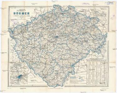
Reisekarte des Königreiches Böhmen
1 : 600000 Bílina (Česko : oblast) Wagner, Jan Eduard Mareš, František F. Kytka
Generální mapa Království českého
1 : 220000 Čechy (Česko) Wagner, Jan Eduard F. Kytka
Přehlední mappa [sic] silnic v Čechách
1 : 680000 Čechy (Česko)
Strassen-Uebersichtskarte von Böhmen
1 : 680000 Čechy (Česko)
Strassenkarte von Böhmen
1 : 441000 Čechy (Česko)
Strassenkarte von Böhmen
1 : 441000 Čechy (Česko)
Koenigreich Boehmen
1 : 360000 Čechy (Česko) Kummersberg, Carl von Schönfelder z Feuersfeldu, František Carl Ritter von Kummersberg
Sněhová pokrývka v Čechách v zimě 1906-1907
Čechy (Česko) Augustin, František Lhota, J. nákladem České společnosti zeměvědné
Hydrographische Übersichtskarte des Elbe-Gebietes und des in Böhmen gelegenen Oder-Gebietes
1 : 750000 Labe (Česko a Německo : řeka : povodí) k.k. hydrographisches Central-Bureau
Hydrographische Übersichtskarte des Elbe-Gebietes und des in Böhmen gelegenen Oder-Gebietes
1 : 750000 Labe-povodí (Česko a Německo) k.k. hydrographisches Central-Bureau
Přehledná geologická mapa Království českého
Čechy (Česko) Počta, Filip Lhota, J. nákladem J. Otty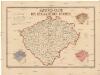
Sanitäts-Carte des Königreiches Böhmen
1 : 606000 Čechy (Česko) Antony, Karl Karl Antony
Entwurf einer statistischen Karte der Maulbeerbaumpflanzungen in Böhmen nach Daten der Bezirksvertrettungen
Čechy (Česko) Patzak, Julius Čeněk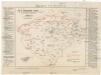
Karte der Wahlkreiseinteilung in Böhmen.
Čechy (Česko) Urban, Karl Lhota, J.
Böhmen
Čechy (Česko)
Böhmen
Čechy (Česko)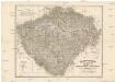
Das chartografische Netz der ombrometrischen Stationen Böhmens
1 : 600000 Čechy (Česko) Purkyně, Emanuel Hickmann, Anton L. böhm. Forstverein
Přírodnická, průmyslnická a zemězpytecká mappa Čech
1 : 864000 Čechy (Česko) Amerling, Karel Porady učitelské v Budči
Přírodní, průmyslnická a zemězpytecká mappa Čech
1 : 864000 Čechy (Česko) Amerling, Karel Porady učitelské v Budči
Přírodnická, průmyslnická a zemězpytecká mappa Čech
1 : 864000 Čechy (Česko) Amerling, Karel Porady učitelské v Budči
Zemězpytecká mappa Čech
1 : 864000 Čechy (Česko) Amerling, Karel Porady učitelské v Budči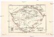
Království české
Čechy (Česko) Kolisko, Hugo Theodor Kolisko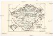
Království české
Čechy (Česko) Kolisko, Hugo Theodor Türke, V. Kolisko
Bez titulu: Soubor statistických map Čech

Karte des Koenigreichs Boehmen
1 : 400000 Čechy (Česko) Loth, Johann Anděl, Bedřich Verlag von Friedrich Kretzschmar
Karte vom Königreiche Böhmen in Cameralämtlicher Hinsicht
Praha (Česko) Seidler, Karl Friedrich
Čechy
Česko Gräf, C. Langhans, J.
Königreich Böhmen
Česko Tachauer, Ludwig Langhans, J.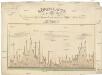
Höhen-Karte, oder, Vergleichende Tafel der barometrischgemessenen Berg- und Städte-Höhen Boehmens
Česko Dlask, Vavřinec Vojtěch Langweil, Antonín Schönfeldische Steindruckerey
Uibersichts-Karte der Rübenzuckerfabricken in Böhmen
1 : 910000 Česko Friedrich, Ernst Koráb, Emil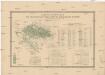
Uebersichts-Karte der Rübenzucker-Production im Königreiche Böhmen
Evropa Bernat, Josef Statist. úřad pro království České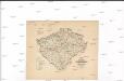
Karte über den industriellen Betrieb mit Metallen im Königreiche Böhmen
1 : 840000 Česko Hickmann, Anton L. Heinrich Mercy
Karte über den industriellen Betrieb mit Nicht-metallischen-Mineralien so wie über das Fluss-Strassen-Eisenbahn & Telegrafennetz des Königreiches Böhmen
1 : 840000 Česko Hickmann, Anton L. Heinrich Mercy