Maps of Czech Republic

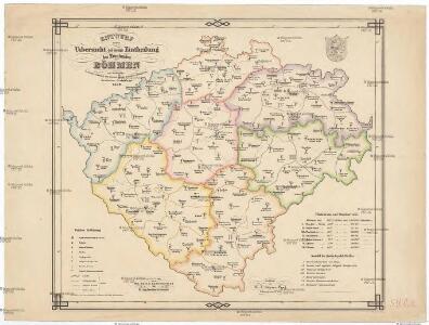
Entwurf einer Uibersicht der neuen Entheilung der Kronlandes Böhmen
Čechy (Česko) Stifter, Johann Steyrer, Fr. C. Fr.C. Steyrer
Geonomická mapa Čech

Strassen- Uibersichts- und Militair-Routen-Karte des Königreichs Böhmen
1 : 580000 Česko Windisch-Graetz, Alfred Kandidus Marco Berra
Mapa příruční Království českého
1 : 600000 Česko Kocen, Blaž Erben, Josef sklad Eduarda Hölzela
Mapa příruční Království českého
1 : 600000 Čechy (Česko) Kocen, Blaž Erben, Josef sklad Eduarda Hölzela
Mapa příruční Království českého
1 : 600000 Česko Kocen, Blaž Erben, Josef sklad Ed. Hölzela
Mittelbach's neueste Specialkarte von Böhmen zum Hand- und Kontorgebrauch
1 : 300000 Česko Mittelbach Mittelbach's Verlag
Topographisch statistische Post und Strassenkarte des Königreiches Boehmen

Čechy, mapa isogon pro epochu 1925.5, Zěmě Moravsko - Slezská, mapa Isogon

Böhmen

Historická mapa Čech
1 : 525000 Česko Palacký, František Kalausek, Josef nákladem Kr. č. učené společnosti
Historická mapa Čech
1 : 525000 Česko Palacký, František Kalousek, Josef nákladem Kr. č. učené společnosti
Generální mappa [sic] Království českého
1 : 432000 Česko Kořistka, Karel František Edvard sklad Eduarda Hölzela
Karte des Königreiches Böhmen

Mapa Království českého
1 : 500000 Čechy (Česko) z uměleckého závodu Eduarda Hölzela
Království české
Česko Šrámek, Ferdinand
Království české
Česko Šrámek, Ferdinand
Království české
Čechy (Česko) Klub národní strany svobodomyslné
Království české
Česko Klub národní strany svobodomyslné
Archäologische Karte des Königreiches Böhmen
Čechy (Česko) Schmitt, Anton Wagner, Jan Eduard Anton Schmitt
Archäologische Karte des Königreiches Böhmen
Čechy (Česko) Schmitt, Anton Wagner, Jan Eduard Anton Schmitt
Archäologische Karte des Königreiches Böhmen
Čechy (Česko) Schmitt, Anton Wagner, Jan Eduard Anton Schmitt
Historisch-geographisch-statistisch-gefaellsaemtliche KARTE vom Königreiche Böhmen
1 : 1040000 Česko Bastien, Joseph Mayregg, Cajetan von Cajetan von Mayregg
Historisch-geographisch-statistisch-gefaellsaemtliche Karte vom Königreiche Böhmen
1 : 1040000 Česko Bastien, Joseph Mayregg, Cajetan von Cajetan von Mayregg
Historisch-geographisch-statistisch-gefaellsaemtliche Karte vom Königreich Böhmen
1 : 1040000 Čechy (Česko) Bastien, Joseph Mayregg, Cajetan von Cajetan von Mayregg
Böhmen

Karte der confessionellen Verhältnisse des Königreiches Böhmen
1 : 600000 Čechy (Česko) Hickmann, Anton L. A.L. Hickmann
Isochronická mapa Čech

Rozdělení okresů školních v Království českém