Maps of Germany

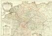
Germania divisa in decem Circulos,
1 : 2400000 Mollova mapová sbírka Valk, Gerhard Valck, Gerard
Botanische Karte von Deutschland.
1 : 3700000 Berghaus, Heinrich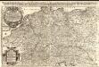
Das Heyl. Römische Reich Teutscher Nation
1 : 2100000 Mollova mapová sbírka Sanson, Guillaume Hipschmann, Sigmund Gabriel Hofmann, Johann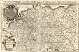
Das Teutsche Keiserthum samt allen darzu gehörigen Chur- und Fürstenthümen Ertz- und Bistumen, Grav- und Herrschaften, auch andern theils daran gräntzenden Ländern und Statten
1 : 2100000 Mollova mapová sbírka Hoffmann, Johannes Hoffmann, Johann
Teutschland die Niederlande und die Schweiz
1 : 2860000 Nizozemsko Streit, Friedrich Wilhelm Boreux, J. J. C. Hinrichssche Buchhandlung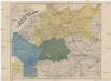
Neueste Eisenbahn- und Kriegs-Karte
Evropa střední A.H. Payne
Geschäfts- und Reise-Karte von Deutschland und den angrenzenden Ländern
Evropa střední Koenig, Theophil R. Drawert
L'Empire d'Allemagne
Mollova mapová sbírka Fer, Nicolas de Danet, Guillaume
[35][35] Accuratissima Germaniae tabula, uit: Atlas sive Descriptio terrarum orbis
Annotatie: Gedigitaliseerde versie. Amsterdam. Heiloo : Picturae (vervaardiger), 2015. tiff-bestand. Gedigitaliseerd: 07-01-2015; Origineel: Universiteitsbibliotheek Vrije Universiteit (XL.05127.-) ; Netherlands; Titelpagina ontbreekt Wit, Frederik de Amsterdam : Frederick de Wit
Homannův atlas světa
1 : 12500000
[Übersicht der Meteorologischen Stationen in Deutschland, der Schweiz, den Niederlanden]
Erster Band, enthaltend in vier Abtheilungen die Erscheinungen der anorganischen Natur: 1. Meteorologie und Klimatographie. 2. Hydrologie und Hydrographie. 3. Geologie. 4. Tellurischer Magnetismus Humboldt, Alexander von Verlag von Justus Perthes
[Botanische Karte von Deutschland; enthaltend die Statistik der vornehmsten Pflanzen-Familien so wie die Isotheren und Isochimenen]
Zweiter Band, enthaltend in vier Abtheilungen die Vertheilung der Organismen: 5. Pflanzen-Geographie, 6. Thier-Geographie, 7. Anthropographie, 8. Ethnographie Humboldt, Alexander von Verlag von Justus Perthes

S. Imperium Romano-Germanicum oder Teutschland mit seinen angräntzenden Königreichen und Provincien
1 : 2420000 Evropa střední Reichelt, Julius Hogeboom, A. durch Nicolaum Visscher
S. Imperium Romano-Germanicum oder Teutschland mit seinen angräntzenden Königreichen und Provincien
1 : 2450000 Evropa střední Reichelt, Julius Hogeboom, Andries durch Nicolaum Visscher
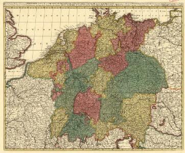
L'Allemagne Divisée en Havte et Basse, et par Cercles, Subdivisée en Etats Ecclesiastiques, Laiques et Villes Imperiales
1 : 2400000 Mollova mapová sbírka Du Tralage, Jean Nicolas Nolin, Jean Baptiste

Imperii Romano-Germanici
1 : 2400000 Mollova mapová sbírka Schatz, Johann Jakob Homann, Johann Baptista - dědici
Imperii Romano-Germanici
1 : 2400000 Mollova mapová sbírka Schatz, Johann Jakob Homann, Johann Baptista - dědici
Imperium Romano-Germanicum
1 : 2400000 Mollova mapová sbírka Homann, Johann Baptist Homann, Johann Baptista - dědici
Imperium Romano-Germanicum
1 : 2400000 Mollova mapová sbírka Homann, Johann Baptist Homann, Johann Baptista - dědici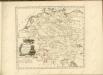

Bez titulu: soubor map pag. 125

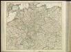
Tabula geographica totius Germaniae
1 : 2426000 Německo Homann, Johann Baptist J. B. Homann
S. Imperium Romano-Germanicum oder Teutschland mit seinen Angräntzenden Königreichen und Provincien
1 : 2500000 Mollova mapová sbírka Visscher, Nicolaes Jansz. Hogeboom, Andries Schenk, Peter II
S. Imperium Romano-Germanicum oder Teutschland mit seinen Angräntzenden Königreichen und Provincien
1 : 2500000 Mollova mapová sbírka Schenk, Pieter Hogeboom, Andries Schenk, Peter II
S. Imperium Romano-Germanicum oder Teutschland mit seinen Angräntzenden Königreichen und Provincien
1 : 2500000 Mollova mapová sbírka Schenk, Pieter Hogeboom, Andries Schenk, Peter II
S[anctum] Imperium Romano-Germanicum oder Teutschland Mit Seinen Angräntzenden Königreichen Und Provincien
Reichelt, Julius; Visscher, Nicolaes; Hogeboom, Andries