Maps of Germany
Botanische Karte von Deutschland.
1 : 3700000 Berghaus, Heinrich
Geschäfts- und Reise-Karte von Deutschland und den angrenzenden Ländern
Evropa střední Koenig, Theophil R. Drawert
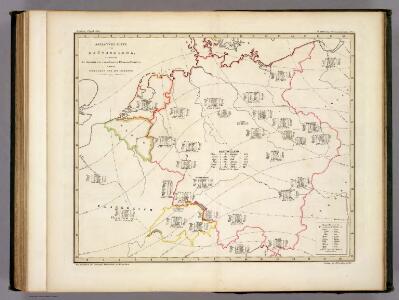
[Übersicht der Meteorologischen Stationen in Deutschland, der Schweiz, den Niederlanden]
Erster Band, enthaltend in vier Abtheilungen die Erscheinungen der anorganischen Natur: 1. Meteorologie und Klimatographie. 2. Hydrologie und Hydrographie. 3. Geologie. 4. Tellurischer Magnetismus Humboldt, Alexander von Verlag von Justus Perthes
[Botanische Karte von Deutschland; enthaltend die Statistik der vornehmsten Pflanzen-Familien so wie die Isotheren und Isochimenen]
Zweiter Band, enthaltend in vier Abtheilungen die Vertheilung der Organismen: 5. Pflanzen-Geographie, 6. Thier-Geographie, 7. Anthropographie, 8. Ethnographie Humboldt, Alexander von Verlag von Justus Perthes
Ubersicht der Meteorologischen Stationen in Deutschland.
1 : 3700000 Berghaus, Heinrich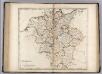
Germany.
1 : 2920000 Carey, Mathew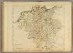
Germany.
1 : 2950000 Carey, Mathew
Bez titulu: soubor map pag. 125
Das Heyl. Römische Reich Teutscher Nation
1 : 2100000 Mollova mapová sbírka Sanson, Guillaume Hipschmann, Sigmund Gabriel Hofmann, Johann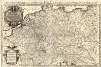
Das Teutsche Keiserthum samt allen darzu gehörigen Chur- und Fürstenthümen Ertz- und Bistumen, Grav- und Herrschaften, auch andern theils daran gräntzenden Ländern und Statten
1 : 2100000 Mollova mapová sbírka Hoffmann, Johannes Hoffmann, Johann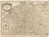
L'empire d'Allemagne
1 : 2600000 Evropa střední Sanson, Guillaume Cordier, Louis chez H. Iaillot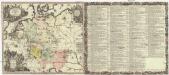
Historia Imperii Romano-Germanici, nec non finitimarum regionum
1 : 2700000 Evropa střední Seutter, Matthäus Matthaeo Seutter
Historia Imperii Romano-Germanici, nec non finitimarum regionum
1 : 2700000 Evropa střední Seutter, Matthäus Matthaeo Seutter
Neueste Post-Charte von Deutschland und den angränzenden Ländern : für Extraposten, Couriere, Diligencen u. Eilwagen / mit benützung der besten Materialien gezeichnet
1 : 1000000 Annotatie: Met afstandentabel Nürnberg : Bauer & Raspe
Mappa geographica exhibens postas omnes tam vehiculares quam veredarias totius Germaniae cum earum accurata distantia
1 : 2500000 diligentissime propriis sumptibus excudit Tobias Conrad Lotter Aug. Vindelicor : Tob. Conr. Lotter
Neueste Eisenbahn-Karte von Deutschland und den angrenzenden Ländern
Evropa střední Walseck, Georg Georg Walseck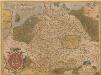
Germania. [Karte], in: Theatrum orbis terrarum, S. 40.
1 Karte aus Atlas Ortelius, Abraham
L'Empire d'Allemagne
Mollova mapová sbírka Fer, Nicolas de Danet, Guillaume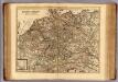
Carte exacte des postes et routes de l'Empire d'Allemagne divisee en ses cercles.
1 : 2500000 Covens et Mortier
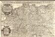
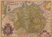
Germania
1 : 3100000 Mollova mapová sbírka Ortelius, Abraham
Germania. [Karte], in: Theatrum orbis terrarum, S. 102.
1 Karte aus Atlas Ortelius, Abraham
Besondere Post und Reise Carte der Wege Durch Teutschland
1 : 3600000 Mollova mapová sbírka
Tabula Geographica totius S[acri] Imperii Romani
1 : 1800000 Mollova mapová sbírka Müller, Johann Ulrich Bodenehr, Georg Conrad
Hydrographica Germaniae...

Imperium Romano-Germanicum
1 : 2600000 Mollova mapová sbírka Seutter, Matthäus Seutter, Matthäus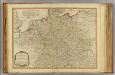
Germany.
1 : 2400000 Robert Laurie & James Whittle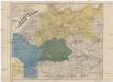
Neueste Eisenbahn- und Kriegs-Karte
Evropa střední A.H. Payne
Neu-vermehrte Post-Charte durch gantz Teutschland nach Italien, Franckreich, Niederland, Preußen, Polen und Ungarn &c.
1 : 2500000 Mollova mapová sbírka Nell, Johann Peter Homann, Johann Baptista