Maps of Germany

L'Empire d'Allemagne
Mollova mapová sbírka Fer, Nicolas de Danet, Guillaume
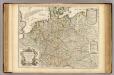
Germania
1 : 3100000 Mollova mapová sbírka Ortelius, Abraham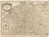
L'empire d'Allemagne
1 : 2600000 Evropa střední Sanson, Guillaume Cordier, Louis chez H. Iaillot
Geschäfts- und Reise-Karte von Deutschland und den angrenzenden Ländern
Evropa střední Koenig, Theophil R. Drawert
[Botanische Karte von Deutschland; enthaltend die Statistik der vornehmsten Pflanzen-Familien so wie die Isotheren und Isochimenen]
Zweiter Band, enthaltend in vier Abtheilungen die Vertheilung der Organismen: 5. Pflanzen-Geographie, 6. Thier-Geographie, 7. Anthropographie, 8. Ethnographie Humboldt, Alexander von Verlag von Justus Perthes
Nieuwe kaart van Duitschland, opgemaakt volgens de naukeurigste waarneemingen
1 : 7250000 [S.l.] : [s.n.]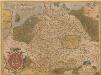
Germania. [Karte], in: Theatrum orbis terrarum, S. 40.
1 Karte aus Atlas Ortelius, Abraham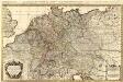
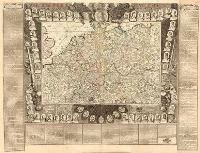
L'Empire d'Allemagne distingué suivant l'étendüe de tous les Estats, Principautés et Souverainetés qui passent ou qui ont passé jusque a present sous le nom d'Allemagne
1 : 2100000 Mollova mapová sbírka Sanson, Guillaume Covens, Johannes I
[Übersicht der Meteorologischen Stationen in Deutschland, der Schweiz, den Niederlanden]
Erster Band, enthaltend in vier Abtheilungen die Erscheinungen der anorganischen Natur: 1. Meteorologie und Klimatographie. 2. Hydrologie und Hydrographie. 3. Geologie. 4. Tellurischer Magnetismus Humboldt, Alexander von Verlag von Justus Perthes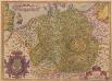
Germania. [Karte], in: Theatrum orbis terrarum, S. 102.
1 Karte aus Atlas Ortelius, Abraham
Neueste Post- und Eisenbah-Charte von Deutschland und der angränzenden Ländern für Extraposten, Couriere, Diligengen, u. Eilwägen
Belgie Bauer & Raspe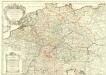
L'Empire d'Allemagne
1 : 2500000 Mollova mapová sbírka Jaillot, Alexis-Hubert Jaillot, Alexis Hubert
Karte von Deutschland und einem Theile der angrenzenden Länder mit Angabe sämmtlicher Eisenbahnen
1 : 2300000 Evropa střední
Post und Reise Karte von Deutschland und den benachbarten Ländern
Evropa střední Schmitfeldt, Georg Mollo, Eduard bey Eduard Mollo
Deutschland, oder, Deutsche Bundesstaaten
1 : 185000 Německo Tranquillo Mollo
Neueste Post-Charte von Deutschland und den angränzenden Ländern : für Extraposten, Couriere, Diligencen u. Eilwagen / mit benützung der besten Materialien gezeichnet
1 : 1000000 Annotatie: Met afstandentabel Nürnberg : Bauer & Raspe
L'Allemagne divisée en ses cercles
1 : 2500000 Mollova mapová sbírka Fer, Nicolas de Loon, Herman van Fer, Nicolas de
L'Allemagne divisée en ses cercles
1 : 2500000 Mollova mapová sbírka Fer, Nicolas de Loon, Herman van Fer, Nicolas de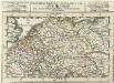
S. Imperium Romano-Germanicum =
1 : 9500000 Mollova mapová sbírka Bodenehr, Gabriel Bodenehr, Gabriel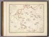
Botanische Karte von Deutschland.
1 : 3700000 Berghaus, Heinrich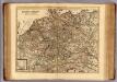
Carte exacte des postes et routes de l'Empire d'Allemagne divisee en ses cercles.
1 : 2500000 Covens et Mortier
Reisekarte von Deutschland und den angrenzenden Ländern
Evropa střední Mahlmann, H. Morin, F. H. F.H. Morin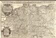
Das Heyl. Römische Reich Teutscher Nation
1 : 2100000 Mollova mapová sbírka Sanson, Guillaume Hipschmann, Sigmund Gabriel Hofmann, Johann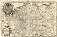
Das Teutsche Keiserthum samt allen darzu gehörigen Chur- und Fürstenthümen Ertz- und Bistumen, Grav- und Herrschaften, auch andern theils daran gräntzenden Ländern und Statten
1 : 2100000 Mollova mapová sbírka Hoffmann, Johannes Hoffmann, Johann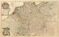
Composite: L'Alemagne.
1 : 1800000 Rizzi Zannoni, Giovanni Antonio Bartolomeo, 1736-1814
Karte von Deutschland
1 : 1880000 Evropa střední Reilly, Franz Johann Josef von Benedicti, Hieronymus Franz Joh. Jos. von Reilly
Karte von Deutschland
1 : 1880000 Evropa střední Reilly, Franz Johann Josef von Benedicti, Hieronymus Franz Joh. Jos. von Reilly
Karte von Deutschland nach Sotzmann
1 : 1880000 Německo Reilly, Franz Johann Josef von Benedicti, Hieronymus Franz Joh. Jos. von Reilly
Post- und Eisenbahnkarte von Deutschland und den benachbarten Laendern
1 : 2450000 Evropa střední Weiland, Karl Ferdinand Mädel, C. J. Geograph. Institut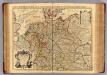
L'Allemagne.
1 : 2500000 L'Isle, Guillaume de, 1675-1726