Maps of Great Britain
De nieuwe aftekening van de Noordzee : van Tessel tot aan Drontem waar in de miswijsing moet verbeterd worden na de opservatie van de heer captijn Suhm
North Sea Suhm Gerard van Keulen
Pas caart van de Noort Zee
1 Karte : Kupferdruck ; 43 x 53 cm Doncker by Hendrick Doncker boeckverkooper en graadbooghmaker in de nieuwbrugh steegh in 't Stuurmans gereedschap
Pascaart vande Noort-Zee [...] gelegen tußchen Calis ende Dronten, als mede tußchen Doeveren en Hitlandt [...] [Karte], in: Het vijfde Deel Des Grooten Atlas : Vervatende De Water-Weereld, S. 145.
1 Karte aus Atlas Jansson, Jan Jansson, Jan
Et nyt forbedret retwisend söe-kaart over nord-söen
1 Karte auf 2 Blatt : Kupferdruck ; 79 x 96 cm + Höeg; Haas s.n.
Nieuwe platte kaart van de Noort Zee strekkende van Frederikstad tot de eylande Ornaal van Schagens Hoek langs de westkuste van Jutland, Holland, & Zeeland tot Middelburg : uit de jongste waarneeminge van Hoegs, Hammons Heiteman en verdere ervaren zeelieden verbeeterd
1 : 350000 Te Amsterdam : te zamengest. en uitg. door Gerard Hulst van Keulen
Statistikk kart 29: The Export of Forest Produce from Norway
1 : 1000000 O. Holmboe
correct chart of the North Sea, with the adjacent coasts of Britain, Holland, Germany, Denmark, Norway, the islands of Orkney and Shetland, the entrance to the Sound and the Baltic Sea
1 : 3400000
North Sea, Kattegat.
1 : 3400000 Faden, William, 1750?-1836
Carte de la mer d'Allemagne
1 Karte : Kupferdruck ; 58 x 81 cm s.n.
Museumskart 154: The North Sea with the Kattegat
1 : 1000000 Pingre | deVerdun | de Borda
The coast of NORWAY from Naze to Paternosters and part of Iutland
from The sea-atlas : containing an hydrographical description of most of the sea-coasts of the known parts of the world.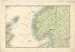
General - Karte von Europa mit Klein - Asien und dem nördlichen Afrika

Feuille 17 (C III), uit: Carte géologique internationale de l'Europe : la carte, votée au congrès géologique international de Bologne en 1881, est exécutée conformément aux décisions d'une commission internationale, avec le concours des gouvernements, sous le dir. de M.M. Beyrich et Hauchecorne
Annotatie: Blad 48 gamme des couleurs; blad 49: bladwijzer en titelblad Heinrich Ernst Beyrich 1815-1896; Wi. Hauchecorne Berlin : Reimer / (Berlin: Institut lithographique)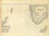
Museumskart 217-6: Kart over Nordsjøen
1 : 500000 S. A. Aarnes Den Geografiske Opmaaling
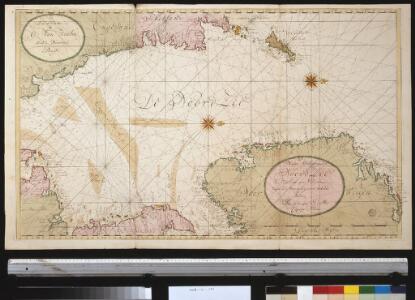
Paskaert van een gedeelte vande Noort Zee Streckende Van Harwitz en Egmon tot Stavanger [...] [Karte], in: De Nieuwe Groote Vermeerderde Zee-Atlas ofte Water-Werelt, S. 17.
1 Karte aus Atlas Doncker, Hendrick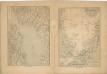
Kriegs Atlas 36 Karten von den Schauplätzen des Weltkrieges 1914/1915

Denmark.
from A system of geography, or, A new & accurate description of the earth in all its empires, kingdoms and states : illustrated with history and topography, and maps of every country : fairly engraven on copper, according to the latest discoveries and corrections / by Herman Moll.
Die britischen Inseln
Velká Británie Wyld, James Kitchin, Thomas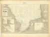
Museumskart 217-7: Kart over Nordsjøen
1 : 500000 S. A. Aarnes Den Geografiske Opmaaling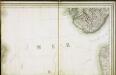
Carte des iles britanniques ou Royaume-Uni de la Grande Bretagne et d'Irlande, 2
2 Blätter : je 50 x 39 cm
Norge 145: Vei Kaart over Norge
1 : 500000 H. G. Bloch | kobberstikk av S. Andersen
Carte des trois royaumes d'Angleterre d'Ècosse et d'Irlande
Velká Británie Raffelsperger, Franz Kitchin, Thomas
Konigreich Grossbrittanien und Irland
Velká Británie Raffelsperger, Franz Kitchin, Thomas
Gross-Britanien und Irland
Velká Británie Raffelsperger, Franz Kitchin, Thomas Franz Raffelsperger
Denmark, pt. of Norway.
1 : 1770000 Society for the Diffusion of Useful Knowledge (Great Britain)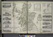
The north part of Great Britain called Scotland.
from The world described, or, A new and correct sett of maps : shewing the kingdoms and states in all the known parts of the earth, with the principal cities, and most considerable towns in the world ... / ... by Herman Moll, geographer ...
Regnum Norwegiae accurata et novissima delineatione
Norsko Lotter, Tobias Conrad Zatta, Antonio sumptibus Tobiae Conradi Lotter
Regnum Norwegiae accurata et novissima delineatione
Norsko Lotter, Tobias Conrad Zatta, Antonio sumptibus Tobiae Conradi Lotter
[Velká Británie a Irsko]
Velká Británie Lotter, Tobias Conrad Lotter, Matthäus Albrecht