Maps of Great Britain

Pascaart vande Noort-Zee [...] gelegen tußchen Calis ende Dronten, als mede tußchen Doeveren en Hitlandt [...] [Karte], in: Het vijfde Deel Des Grooten Atlas : Vervatende De Water-Weereld, S. 145.
1 Karte aus Atlas Jansson, Jan Jansson, Jan
Pascaart vande Noort-Zee Waer in vertoont wort [...] Tabula Hydrographica Oceani Borealis [...] [Karte], in: Novus atlas absolutissimus, Bd. 9, S. 194.
1 Karte aus Atlas Janssonius Offizin
Pas caart van de Noort Zee
1 Karte : Kupferdruck ; 43 x 53 cm Doncker by Hendrick Doncker boeckverkooper en graadbooghmaker in de nieuwbrugh steegh in 't Stuurmans gereedschap
Pas Caart van de Noort Zee .. Verthoonende in zich alle de Custen en Havens daer rontom gelegen. [Karte], in: De Nieuwe Groote Vermeerderde Zee-Atlas ofte Water-Werelt, S. 15.
1 Karte aus Atlas Doncker, Hendrick
Museumskart 154: The North Sea with the Kattegat
1 : 1000000 Pingre | deVerdun | de Borda
Erdkarte zur Übersicht des Kolonialbesitzes, der konsularischen und
1 : 50000000 Kiepert, Richard ; Limpricht, Max Geographische Verlagshandlung Dietrich Reimer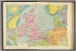
North Sea.
1 : 5000000 Philip, George
North Sea, Kattegat.
1 : 3400000 Faden, William, 1750?-1836
[123][126] Pascaert vande Noort-Zee om achter Yrland en Schotland om te seylen, uit: Atlas sive Descriptio terrarum orbis
Annotatie: Gedigitaliseerde versie. Amsterdam. Heiloo : Picturae (vervaardiger), 2015. tiff-bestand. Gedigitaliseerd: 07-01-2015; Origineel: Universiteitsbibliotheek Vrije Universiteit (XL.05127.-) ; Netherlands; Titelpagina ontbreekt Wit, Frederik de Amsterdam : Frederick de Wit
Mare Germanicum ac tractus maritimus retro Hiberniam et Scotiam
1 Karte : Kupferdruck ; 47 x 56 cm Renard apud L. Renard
Statistikk kart 29: The Export of Forest Produce from Norway
1 : 1000000 O. Holmboe
De nieuwe aftekening van de Noordzee : van Tessel tot aan Drontem waar in de miswijsing moet verbeterd worden na de opservatie van de heer captijn Suhm
North Sea Suhm Gerard van Keulen
North, Baltic seas.
1 : 3600000 Thomson, John
Carte générale aéronautique internationale
1 : 2186607 Evropa střední Ministerstvo veřejných prací
Carte générale aéronautique internationale
1 : 2186607 Evropa střední nákladem Ministerstva veřejných věcí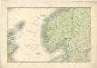
General - Karte von Europa mit Klein - Asien und dem nördlichen Afrika

British Isles - Physical Geography..
Milner, Thomas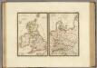
Iles Britanniques anciennes, Germanie ancienne, Rhetie, Pannonie, Norique.
1 : 3800000 Brue, Adrien Hubert, 1786-1832
Carte générale aeronautique internationale
1 : 2186607 Belgie Service géographique de l'Armée française
Carte des places fortes et des principaux ports des isles britanniques et des etats d'Hanovre
1 Karte : Kupferdruck ; 48 x 60 cm Brion de la Tour; Longchamps chés le Sr. Longchamps géographe rue St. Jacques à l'enseigne de la place des Victoires
Kriegskarte der Nordsee
1 : 3350000 Severní moře-oblast Max Freissler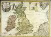
Carte des isles Britanniques contenant les royaumes d'Angleterre, d'Ecosse, d'Irlande et isles dépendantes
1 Karte : Kupferdruck ; 53 x 72 cm Flink; Mondhare chés Mondhare rue St. Jacques
Die Britischen Inseln Und Das Umliegende Meer.
1 : 3700000 Petermann, A.
England und die Nordseeländer
1 : 3500000 Severní moře (oblast) Kartogr. Anst. Freytag & Berndt
Die Britischen Inseln: Volker und Sprachen.
1 : 3800000 Berghaus, Heinrich
Et nyt forbedret retwisend söe-kaart over nord-söen
1 Karte auf 2 Blatt : Kupferdruck ; 79 x 96 cm + Höeg; Haas s.n.
The coast of NORWAY from Naze to Paternosters and part of Iutland
from The sea-atlas : containing an hydrographical description of most of the sea-coasts of the known parts of the world.
Nieuwe platte kaart van de Noort Zee strekkende van Frederikstad tot de eylande Ornaal van Schagens Hoek langs de westkuste van Jutland, Holland, & Zeeland tot Middelburg : uit de jongste waarneeminge van Hoegs, Hammons Heiteman en verdere ervaren zeelieden verbeeterd
1 : 350000 Te Amsterdam : te zamengest. en uitg. door Gerard Hulst van Keulen
correct chart of the North Sea, with the adjacent coasts of Britain, Holland, Germany, Denmark, Norway, the islands of Orkney and Shetland, the entrance to the Sound and the Baltic Sea
1 : 3400000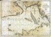
![Pascaart vande Noort-Zee [...] gelegen tußchen Calis ende Dronten, als mede tußchen Doeveren en Hitlandt [...] [Karte], in: Het vijfde Deel Des Grooten Atlas : Vervatende De Water-Weereld, S. 145.](https://images-2.georeferencer.com/images/iiif/764981782222/full/,300/0/native.jpg)

