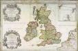
Maps of Great Britain

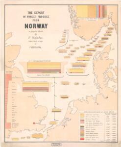
Statistikk kart 29: The Export of Forest Produce from Norway
1 : 1000000 O. Holmboe
North Sea.
1 : 5000000 Philip, George
England und die Nordseeländer
1 : 3500000 Severní moře (oblast) Kartogr. Anst. Freytag & Berndt
Museumskart 154: The North Sea with the Kattegat
1 : 1000000 Pingre | deVerdun | de Borda
Pascaart vande Noort-Zee [...] gelegen tußchen Calis ende Dronten, als mede tußchen Doeveren en Hitlandt [...] [Karte], in: Het vijfde Deel Des Grooten Atlas : Vervatende De Water-Weereld, S. 145.
1 Karte aus Atlas Jansson, Jan Jansson, Jan
Pas caart van de Noort Zee
1 Karte : Kupferdruck ; 43 x 53 cm Doncker by Hendrick Doncker boeckverkooper en graadbooghmaker in de nieuwbrugh steegh in 't Stuurmans gereedschap
Kriegskarte der Nordsee
1 : 3350000 Severní moře-oblast Max Freissler
Mare Germanicum ac tractus maritimus retro Hiberniam et Scotiam
1 Karte : Kupferdruck ; 47 x 56 cm Renard apud L. Renard
Pascaart vande Noort-Zee Waer in vertoont wort [...] Tabula Hydrographica Oceani Borealis [...] [Karte], in: Novus atlas absolutissimus, Bd. 9, S. 194.
1 Karte aus Atlas Janssonius Offizin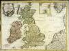
Carte des isles Britanniques contenant les royaumes d'Angleterre, d'Ecosse, d'Irlande et isles dépendantes
1 Karte : Kupferdruck ; 53 x 72 cm Flink; Mondhare chés Mondhare rue St. Jacques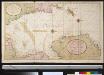
De nieuwe aftekening van de Noordzee : van Tessel tot aan Drontem waar in de miswijsing moet verbeterd worden na de opservatie van de heer captijn Suhm
North Sea Suhm Gerard van Keulen
The coast of NORWAY from Naze to Paternosters and part of Iutland
from The sea-atlas : containing an hydrographical description of most of the sea-coasts of the known parts of the world.
North Sea, Kattegat.
1 : 3400000 Faden, William, 1750?-1836
Erdkarte zur Übersicht des Kolonialbesitzes, der konsularischen und
1 : 50000000 Kiepert, Richard ; Limpricht, Max Geographische Verlagshandlung Dietrich Reimer
Et nyt forbedret retwisend söe-kaart over nord-söen
1 Karte auf 2 Blatt : Kupferdruck ; 79 x 96 cm + Höeg; Haas s.n.
Nieuwe platte kaart van de Noort Zee strekkende van Frederikstad tot de eylande Ornaal van Schagens Hoek langs de westkuste van Jutland, Holland, & Zeeland tot Middelburg : uit de jongste waarneeminge van Hoegs, Hammons Heiteman en verdere ervaren zeelieden verbeeterd
1 : 350000 Te Amsterdam : te zamengest. en uitg. door Gerard Hulst van Keulen
Carte des places fortes et des principaux ports des isles britanniques et des etats d'Hanovre
1 Karte : Kupferdruck ; 48 x 60 cm Brion de la Tour; Longchamps chés le Sr. Longchamps géographe rue St. Jacques à l'enseigne de la place des Victoires
Die Britischen Inseln Und Das Umliegende Meer.
1 : 3700000 Petermann, A.
Carte générale aéronautique internationale
1 : 2186607 Evropa střední Ministerstvo veřejných prací
Carte générale aéronautique internationale
1 : 2186607 Evropa střední nákladem Ministerstva veřejných věcí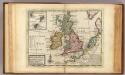
A general map of Great Britain and Ireland.
1 : 7500000 Moll, Herman, d. 1732
Die Britischen Inseln und das Umliegende Meer
Hand-Atlas über alle Theile der Erde und über das Weltgebäude Stieler, Adolf Justus Perthes
Die Britischen Inseln: Volker und Sprachen.
1 : 3800000 Berghaus, Heinrich
Die Britischen Inseln und die Nord-See
Hand-Atlas über alle Theile der Erde nach dem neuesten Zustande und über das Weltgebäude Stieler, Adolf bei Justus Perthes
Insvlæ Albion et Hibernia
1 Karte : Kupferdruck ; 37 x 43 cm Blaeu Joan Blaeu
Les isles britanniques ou sont le r.me d'Angleterre tiré de Sped celuy d'Ecosse tiré de Th. Pont
1 Karte : Kupferdruck ; 46 x 60 cm L'Isle; Buache; Petty; Speed; Pont chéz l'auteur sur le quai de l'Horloge a l'aigle d'or
Les isles britanniques ou sont le r.me d'Angleterre tiré de Sped celuy d'Ecosse tiré de Th. Pont
1 Karte : Kupferdruck ; 46 x 60 cm L'Isle; Buache; Petty; Speed; Pont; Dezauche chéz Dezauche successeur des S.rs de l'Isle et Buache rue des Noyers
Les isles britanniques ou sont le r.me d'Angleterre tiré de Sped celuy d'Ecosse tiré de Th. Pont
1 Karte : Kupferdruck ; 46 x 60 cm L'Isle; Liébaux; Petty; Speed; Pont chéz l'auteur sur le quai de l'Horloge a l'aigle d'or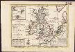
A general map of Great Britain and Ireland, with part of Germany, Holland, Flanders, France &c. agreeable to modern history
1 : 6500000
Les isles britanniques ou les royaumes d'Angleterre, d'Ecosse et d'Irlande
1 Karte : Kupferdruck ; 48 x 62 cm Le Rouge Le Rouge rue des Augustins vis a vis le panier Fleury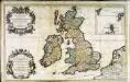
Les isles britanniques; qui contiennent les royaumes, d'Angleterre, Escosse, et Irlande
1 Karte auf 2 Blätter : Kupferdruck ; 53 x 85 cm Sanson; Jaillot; Speed; Gordon; Pont; Saxton; Camden; Boazio chez H. Iaillot joignant les grands Augustins aux deux globes