Maps of Denmark

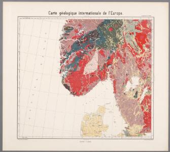
Feuille 17 (C III), uit: Carte géologique internationale de l'Europe : la carte, votée au congrès géologique international de Bologne en 1881, est exécutée conformément aux décisions d'une commission internationale, avec le concours des gouvernements, sous le dir. de M.M. Beyrich et Hauchecorne
Annotatie: Blad 48 gamme des couleurs; blad 49: bladwijzer en titelblad Heinrich Ernst Beyrich 1815-1896; Wi. Hauchecorne Berlin : Reimer / (Berlin: Institut lithographique)
Norgesavdelingen 156: Noregr - Det gamle Norge før Aar 1500
1 : 1500000 Gerhard Munthe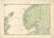
General - Karte von Europa mit Klein - Asien und dem nördlichen Afrika

Southern Scandinavia & Denmark.
1 : 2000000 John Bartholomew and Son
Südskandinavien
1 : 2500000 Oslo (Norsko) Justus Perthes
Spesielle kart 79: Kart over legemshöiden i Norge (sydl.del)
Jonas Vestly Den private Opmaalings lith. Anstalt. Kristiania
Norge 79: Kongeriget Norge afdelet i sine fiire Stifter; samt underliggende Provstier
1 : 600000 O. A. Wangensteen
Denmark.
from A system of geography, or, A new & accurate description of the earth in all its empires, kingdoms and states : illustrated with history and topography, and maps of every country : fairly engraven on copper, according to the latest discoveries and corrections / by Herman Moll.
Norge 145: Vei Kaart over Norge
1 : 500000 H. G. Bloch | kobberstikk av S. Andersen
Geistlig inndelingskart over Sør-Norge, Oslo, Hamar, Agder, Bjørgvin og Nidaros Bispedømmer
1 : 1000000
Statistikk 4 Originaltegning til General Nissens statistiske kart. Sør og Nord Norge
1 : 2000000
Spesielle kart 2-1: Norges jernbaner i 1851
1 : 1000000
Spesielle kart 2-5: Norges jernbaner i 1876
1 : 1000000
Spesielle kart 173a: Oversiktskart over Nivellementer i SÃ ̧r-Norge
1 : 100000
Spesielle kart 63: Pflanzengeographische Karte Über Das Königreich Norwegen, blad 4
1 : 1000000 F. C. Schübeler
Spesielle kart 2-4: Norges jernbaner i 1869
1 : 1000000
Postkart for det Sydlige Norge
1 : 100000
Spesielle kart nr 75: De norske raser og storbræen
1 : 2000000 Andr. M. Hansen
Spesielle kart 65-4: Oversigtskart over de paa den norske Kyst anbragte Fyre
1 : 1000000
Geologiske kart 49: Geologisk oversigtskart over Det sydlige Norge
1 : 2400000 K. M. Hauan | Tellef Dahll | Theodor Kjerulf | Th. Hjortdahl | M. Irgens
Geologisk kart 51-3: Geologisk kart over Norge
1 : 1000000 O. Holtedahl | Johannes A. Dons Norges geologiske undersøkelse
Spesielle kart 30-2: Postkart over det sydlige Norge
1 : 1200000
Post Karte von Schweden und Norwegen nach Meilen
Norsko Hallberg, von Santjohanser, N.
Spesielle kart 16: Map of railways in Norway
1 : 1000000
Legedistrikter i Sør-Norge
1 : 1600000 Det private Opmaalingskonor
Norgesavdelingen 156: Noregr - Det gamle Norge før Aar 1500
1 : 1500000 Gerhard Munthe
Norge 165: General Kart over den sydlige Del af Kongeriget Norge
1 : 100000 Carl B. Roosen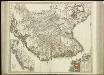
[70][70] Norvegia Regnum ..., uit: Atlas sive Descriptio terrarum orbis
Annotatie: Gedigitaliseerde versie. Amsterdam. Heiloo : Picturae (vervaardiger), 2015. tiff-bestand. Gedigitaliseerd: 07-01-2015; Origineel: Universiteitsbibliotheek Vrije Universiteit (XL.05127.-) ; Netherlands; Titelpagina ontbreekt Wit, Frederik de Amsterdam : Frederick de Wit
Statistikk 37: Industrikarten von Norwegen
1 : 1000000 A. Lyle