Maps of Sweden

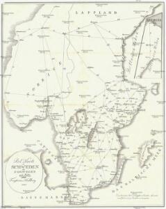
Post Karte von Schweden und Norwegen nach Meilen
Norsko Hallberg, von Santjohanser, N.
Sweden, Norway.
1 : 2200000 Arrowsmith, John
55-56. Scandanavia, South. The World Atlas.
1 : 2500000 USSR (Union of Soviet Socialist Republics).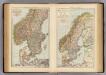
S. Scandinavia, Norway, Sweden.
1 : 4000000 Andree, Richard; Times (London, England)

Scandanavie Flle. S.
1 : 2500000 Vivien St Martin, L.
Statistikk kart 6 sør: Norvége. Densité de la population en 1865
1 : 1000000
Southern Scandinavia & Denmark.
1 : 2000000 John Bartholomew and Son
Norge 3: Norgesavelingen 3. Geometrisch Declineation af Trundhems så och en Deel af de angänsende Akershus og Bergenhus Læhn.
J. Jürgens
[VIII], uit: Geognostische Karte des Oesterreichischen Kaiserstaates mit einem grossen Theile Deutschland's u. Italien / hauptsachlich nach ... Haidinger's geognostischer Karte dieses Staates bearb. von Josef Scheda
1 : 3000000 titelvariant: General-Karte von Europa in 25 Blättern; Annotatie: Bijlage bij: General-Karte von Europa in 25 Blättern. - 1:2.592.000. - 1845-1847 Scheda, Joseph Wien : K.K. Militär. Geografisch. Institut
Südskandinavien
1 : 2500000 Oslo (Norsko) Justus Perthes
Karte von dem Königreiche Norwegen
1 : 1470000 Norsko Reilly, Franz Johann Josef von Stöber, Joseph von Franz Ioh. Ios. von Reilly
Legedistrikter i Sør-Norge
1 : 1600000 Det private Opmaalingskonor
Geologiske kart 49: Geologisk oversigtskart over Det sydlige Norge
1 : 2400000 K. M. Hauan | Tellef Dahll | Theodor Kjerulf | Th. Hjortdahl | M. Irgens

Norgesavdelingen 156: Noregr - Det gamle Norge før Aar 1500
1 : 1500000 Gerhard Munthe
Statistikk 3 Kart over upplæringsmålet i folkeskulen
1 : 1000000 Peder Hovdan Noregs Mållag
Norge 8 Carte over Konge-Riget Norrge med nest der indtill grentzende svenske Provincer.
1 : 800000 Engelbret Hoff
Spesielle kart 79: Kart over legemshöiden i Norge (sydl.del)
Jonas Vestly Den private Opmaalings lith. Anstalt. Kristiania
[Schweden und Norwegen auch Dänemark, Südliches Blatt]
Hand-Atlas über alle Theile der Erde nach dem neuesten Zustande und über das Weltgebäude Stieler, Adolf bei Justus Perthes
Postkart for det Sydlige Norge
1 : 100000
Regni Norvegiæ accvrata tabvla
1 Karte : Kupferdruck ; 57 x 48 cm Homann Johann Baptist Homann
Regni Norvegiæ accvrata tabvla
1 Karte : Kupferdruck ; 57 x 49 cm Homann Johann Baptist Homann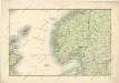
General - Karte von Europa mit Klein - Asien und dem nördlichen Afrika

Geistlig inndelingskart over Sør-Norge, Oslo, Hamar, Agder, Bjørgvin og Nidaros Bispedømmer
1 : 1000000
Geological Map of the Pre-Quaternary Systems of Sweden
1 : 1500000 Švédsko Törnebohm, A. E. The Geological Survey of Sweden
Feuille 17 (C III), uit: Carte géologique internationale de l'Europe : la carte, votée au congrès géologique international de Bologne en 1881, est exécutée conformément aux décisions d'une commission internationale, avec le concours des gouvernements, sous le dir. de M.M. Beyrich et Hauchecorne
Annotatie: Blad 48 gamme des couleurs; blad 49: bladwijzer en titelblad Heinrich Ernst Beyrich 1815-1896; Wi. Hauchecorne Berlin : Reimer / (Berlin: Institut lithographique)
Norge 79: Kongeriget Norge afdelet i sine fiire Stifter; samt underliggende Provstier
1 : 600000 O. A. Wangensteen
Geologiske kart 44: Geologisk oversigtskart over det sydlige Norge
1 : 1000000 K. O. Bjørlykke Albert Cammermeyer Forlag