Maps of Fort William
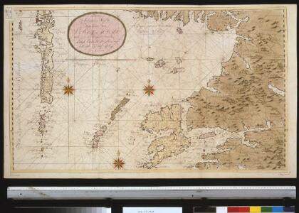
Nieuwe afteekening van de West kust van SchotLandt als mede een gedeelte van de Lewijs Eijlanden en Skie, Mulla, Tijrrif, Col int groot
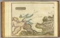
Scotland Gerard van Keulen
Lochabria, omnesque Insulae versus Occidentem sitae, ut Uisto, Mulla, aliaeque. [Karte], in: Novus atlas absolutissimus, Bd. 8, S. 172.
1 Karte aus Atlas Janssonius Offizin
Lochabria, omnesq[ue] insulæ versus occidentem sitæ, ut Visto, Mulla, aliæque
1 Karte : Kupferdruck ; 42 x 51 cm Valck; Schenk sumptibus Gerardi Valk et Petri Schenk
Scotland / J. Ainslie, 4
1 Blatt : 67 x 58 cm Ainslie, Faden
Argyllshire N.
1 : 175000 Thomson, John
Ardnamurchan to Summer Isles, including the Inner Channel and part of the Minch.
Great Britain. Hydrographic Office
Arisaig & Rum, Sheet 14 - Bartholomew's "Half Inch to the Mile Maps" of Scotland
1 : 126720 Topographic maps John Bartholomew & Son, Ltd John Bartholomew & Son, Ltd
Mallaig, Sheet 14 - Bartholomew's "Half Inch to the Mile Maps" of Scotland
1 : 126720 Topographic maps Bartholomew, John George John Bartholomew & Co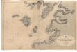
Ardnamurchan Point to Loch Bhreatal, Skye, including the Small Isles and Sleat Sound
Great Britain. Hydrographic Office
MVLA INSVLA, | quæ ex Æbudarum numero una est, | et Lochabriæ ad occasum prætenditur. | THE YLE OF MVL | whiche is one of the westerne Yles, | and lyeth ovir [!] against Lochabyr
Auct. Timoth. Pont. [Amsterdam : Joan Blaeu]
The south part of Sky Island and the adjacent main of Scotland.
Mackenzie, Murdoch (Senior), 1712-1797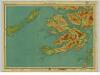
Mull & Iona, Sheet 10 - Bartholomew's "Half Inch to the Mile Maps" of Scotland
1 : 126720 Topographic maps John Bartholomew & Son, Ltd John Bartholomew & Son, Ltd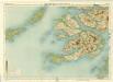
Mull, Sheet 10 - Bartholomew's "Half Inch to the Mile Maps" of Scotland
1 : 126720 Topographic maps Bartholomew, John George John Bartholomew & Co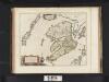
Mula Insula, quae ex Aebudarum numero una est, et Lochabriae ad occasum praetenditur. The Yle of Mul whiche is one of the Westerne Yles, and lyeth ovir against Lochabyr / Auct. Timoth. Pont.
Pont, Timothy, 1560?-1614? Blaeu, Joan, 1596-1673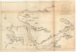
The sound of Mull.
Mackenzie, Murdoch (Senior), 1712-1797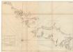
The south part of Long Island from Bara Head to Benbecula I.
Bowen, Thomas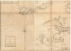
The west side of the island Mull with the islands Tiri and Coll.
Mackenzie, Murdoch (Senior), 1712-1797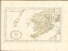
Inverness Shire 4 N.
1 : 128000 Johnson, William, fl. 1806-1840
Ardnamurchan - Bartholomew's 'Survey Atlas of Scotland'
1 : 126720 Topographic maps John Bartholomew & Son, Ltd John Bartholomew & Son, Ltd
Rum, Cuillins - Bartholomew's 'Survey Atlas of Scotland'
1 : 126720 Topographic maps John Bartholomew & Son, Ltd John Bartholomew & Son, Ltd
Oban, Fort William - Bartholomew's 'Survey Atlas of Scotland'
1 : 126720 Topographic maps John Bartholomew & Son, Ltd John Bartholomew & Son, Ltd
Mvla insvla
1 Karte : Kupferdruck ; 41 x 53 cm Blaeu; Pont Joan Blaeu
Skye Island &c.
1 : 139000 Johnson, William, fl. 1806-1840
Glenelg, etc. - Bartholomew's 'Survey Atlas of Scotland'
1 : 126720 Topographic maps John Bartholomew & Son, Ltd John Bartholomew & Son, Ltd
INSVLÆ QVÆDAM MINORES | ex Æbudis quæ MVLAM et SKIAM | insulas interjacent. | SOME OF THE SMALLER WESTERNE YLES, lying betweene the Yles of MVLE and SKYE.
Timoth: Pont auctor. [Amsterdam : Joan Blaeu]
Coll and Tiree - OS One-Inch Map
1 : 63360 Topographic maps Ordnance Survey Ordnance Survey
Loch Linnhe - OS One-Inch Map
1 : 63360 Topographic maps Ordnance Survey Ordnance Survey
Sound of Mull - OS One-Inch Map
1 : 63360 Topographic maps Ordnance Survey Ordnance Survey