Maps of Highland

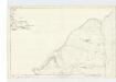
The south part of Sky Island and the adjacent main of Scotland.
Mackenzie, Murdoch (Senior), 1712-1797
Island of Skye
1 : 126720 Ordnance Survey Office
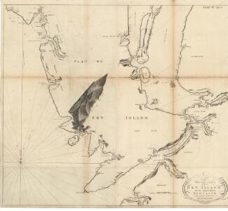
Skia vel Skiana
1 Karte : Kupferdruck ; 40 x 51 cm Blaeu; Pont Joan Blaeu
Skia vel Skiana, [vulgo], The Yle of Skie / Auct. Timotheo Pont.
Pont, Timothy, 1560?-1614? Blaeu, Joan, 1596-1673
SKIA vel SKIANA | The Yle of SKIE
Auct. Timotheo Pont. [Amsterdam : Joan Blaeu]
Sound of Sleat (35) - OS One-Inch map
1 : 63360 Topographic maps Ordnance Survey Ordnance Survey
Sound of Sleat (35) - OS One-Inch map
1 : 63360 Topographic maps Ordnance Survey Ordnance Survey
Rhum and Part of Skye - OS One-Inch Map
1 : 63360 Topographic maps Ordnance Survey Ordnance Survey
The Cuillins, Rhum & Canna (34) - OS One-Inch map
1 : 63360 Topographic maps Ordnance Survey Ordnance Survey
The Cuillins, Rhum & Canna (34) - OS One-Inch map
1 : 63360 Topographic maps Ordnance Survey Ordnance Survey
Inverness Shire 4 N.
1 : 128000 Johnson, William, fl. 1806-1840
Glenelg, etc. - Bartholomew's 'Survey Atlas of Scotland'
1 : 126720 Topographic maps John Bartholomew & Son, Ltd John Bartholomew & Son, Ltd
South Skye and Arisaig - OS One-Inch Map
1 : 63360 Topographic maps Ordnance Survey Ordnance Survey
Portree - OS One-Inch Map
1 : 63360 Topographic maps Ordnance Survey Ordnance Survey
Glenelg - OS One-Inch map
1 : 63360 Topographic maps Ordnance Survey Ordnance Survey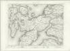
Glenelg - OS One-Inch map
1 : 63360 Topographic maps Ordnance Survey Ordnance Survey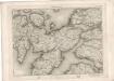
Glenelg - OS One-Inch map
1 : 63360 Topographic maps Ordnance Survey Ordnance Survey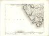
Minginish - OS One-Inch map
1 : 63360 Topographic maps Ordnance Survey Ordnance Survey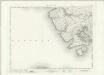
Minginish - OS One-Inch map
1 : 63360 Topographic maps Ordnance Survey Ordnance Survey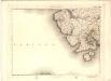
Minginish - OS One-Inch map
1 : 63360 Topographic maps Ordnance Survey Ordnance Survey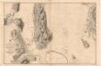
Southern part of the Sound of Raasay and Inner Sound
Great Britain. Hydrographic Office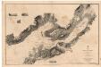
Loch Carron and Loch Kishorn
Great Britain. Hydrographic Office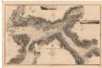
Loch Alsh and Loch Duich
Great Britain. Hydrographic Office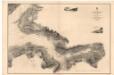
Loch Hourn
Great Britain. Hydrographic Office
Sleat Sound
Great Britain. Hydrographic Office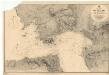
Inverie Bay and Approach
Great Britain. Hydrographic Office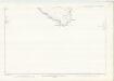
Inverness-shire (Isle of Skye), Sheet XXXII & XXXIIA - OS 6 Inch map
1 : 10560 Topographic maps Ordnance Survey Ordnance Survey
Argyllshire (Islands of Canna & Sanday), Sheet LIX - OS 6 Inch map
1 : 10560 Topographic maps Ordnance Survey Ordnance Survey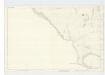
Argyllshire (Island of Rum), Sheet LXVI - OS 6 Inch map
1 : 10560 Topographic maps Ordnance Survey Ordnance Survey