Maps of Fort William
Argyllshire N.
1 : 175000 Thomson, John
MVLA INSVLA, | quæ ex Æbudarum numero una est, | et Lochabriæ ad occasum prætenditur. | THE YLE OF MVL | whiche is one of the westerne Yles, | and lyeth ovir [!] against Lochabyr
Auct. Timoth. Pont. [Amsterdam : Joan Blaeu]
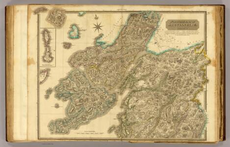
Inverness Shire 6 S.
1 : 128000 Thomson, John
The sound of Mull.
Mackenzie, Murdoch (Senior), 1712-1797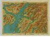
Argyll, Sheet 11 - Bartholomew's "Half Inch to the Mile Maps" of Scotland
1 : 126720 Topographic maps John Bartholomew & Son, Ltd John Bartholomew & Son, Ltd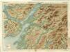
Oban & Loch Awe, Sheet 11 - Bartholomew's "Half Inch to the Mile Maps" of Scotland
1 : 126720 Topographic maps Bartholomew, John George John Bartholomew & Co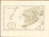
Mull & Iona, Sheet 10 - Bartholomew's "Half Inch to the Mile Maps" of Scotland
1 : 126720 Topographic maps John Bartholomew & Son, Ltd John Bartholomew & Son, Ltd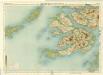
Mull, Sheet 10 - Bartholomew's "Half Inch to the Mile Maps" of Scotland
1 : 126720 Topographic maps Bartholomew, John George John Bartholomew & Co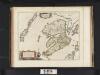
Mula Insula, quae ex Aebudarum numero una est, et Lochabriae ad occasum praetenditur. The Yle of Mul whiche is one of the Westerne Yles, and lyeth ovir against Lochabyr / Auct. Timoth. Pont.
Pont, Timothy, 1560?-1614? Blaeu, Joan, 1596-1673
Mvla insvla
1 Karte : Kupferdruck ; 41 x 53 cm Blaeu; Pont Joan Blaeu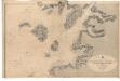
Ardnamurchan Point to Loch Bhreatal, Skye, including the Small Isles and Sleat Sound
Great Britain. Hydrographic Office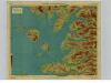
Arisaig & Rum, Sheet 14 - Bartholomew's "Half Inch to the Mile Maps" of Scotland
1 : 126720 Topographic maps John Bartholomew & Son, Ltd John Bartholomew & Son, Ltd
Mallaig, Sheet 14 - Bartholomew's "Half Inch to the Mile Maps" of Scotland
1 : 126720 Topographic maps Bartholomew, John George John Bartholomew & Co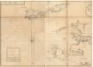
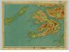
The west side of the island Mull with the islands Tiri and Coll.
Mackenzie, Murdoch (Senior), 1712-1797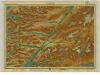
Lochaber, Sheet 15 - Bartholomew's "Half Inch to the Mile Maps" of Scotland
1 : 126720 Topographic maps John Bartholomew & Son, Ltd John Bartholomew & Son, Ltd
Fort-William District, Sheet 15 - Bartholomew's "Half Inch to the Mile Maps" of Scotland
1 : 126720 Topographic maps Bartholomew, John George John Bartholomew & Co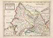
The West Part of Inverness Sh. Lochaber with all the Territories west from it / by H. Moll.
Moll, Herman, d. 1732
Oban, Fort William - Bartholomew's 'Survey Atlas of Scotland'
1 : 126720 Topographic maps John Bartholomew & Son, Ltd John Bartholomew & Son, Ltd
Loch Linnhe - OS One-Inch Map
1 : 63360 Topographic maps Ordnance Survey Ordnance Survey
Sound of Mull - OS One-Inch Map
1 : 63360 Topographic maps Ordnance Survey Ordnance Survey
Ardnamurchan - Bartholomew's 'Survey Atlas of Scotland'
1 : 126720 Topographic maps John Bartholomew & Son, Ltd John Bartholomew & Son, Ltd
Coll and Tiree - OS One-Inch Map
1 : 63360 Topographic maps Ordnance Survey Ordnance Survey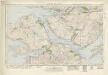
Sound of Mull (53) - OS One-Inch map
1 : 63360 Topographic maps Ordnance Survey Ordnance Survey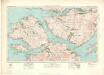
Sound of Mull (53) - OS One-Inch map
1 : 63360 Topographic maps Ordnance Survey Ordnance Survey
Ardnamurchan & Loch Shiel (46) - OS One-Inch map
1 : 63360 Topographic maps Ordnance Survey Ordnance Survey
Ardnamurchan & Loch Shiel (46) - OS One-Inch map
1 : 63360 Topographic maps Ordnance Survey Ordnance Survey
Ben Nevis & Fort William (47) - OS One-Inch map
1 : 63360 Topographic maps Ordnance Survey Ordnance Survey
Ben Nevis & Fort William (47) - OS One-Inch map
1 : 63360 Topographic maps Ordnance Survey Ordnance Survey
Loch Etive & Glen Coe (54) - OS One-Inch map
1 : 63360 Topographic maps Ordnance Survey Ordnance Survey