Maps of Fort William

Lochabria, omnesque Insulae versus Occidentem sitae, ut Uisto, Mulla, aliaeque. [Karte], in: Novus atlas absolutissimus, Bd. 8, S. 172.
1 Karte aus Atlas Janssonius Offizin
Lochabria, omnesq[ue] insulæ versus occidentem sitæ, ut Visto, Mulla, aliæque
1 Karte : Kupferdruck ; 42 x 51 cm Valck; Schenk sumptibus Gerardi Valk et Petri Schenk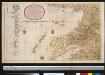
Nieuwe afteekening van de West kust van SchotLandt als mede een gedeelte van de Lewijs Eijlanden en Skie, Mulla, Tijrrif, Col int groot
Scotland Gerard van Keulen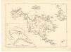
Map of St Kilda or Hirta and adjacent islands...
Mathieson, John
St Kilda.
Stevenson, Robert, 1772-1850
Scotland / J. Ainslie, 4
1 Blatt : 67 x 58 cm Ainslie, Faden
Ordnance Survey of Great Britain, Scotland
Ordnance Survey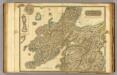
Argyllshire N.
1 : 175000 Thomson, John
Scotland / J. Ainslie, 5
1 Blatt : 67 x 57 cm Ainslie, Faden
Scotiæ provinciæ mediterraneæ inter Taum flumen et vararis æstuarium: sunt autem Braid-Allaban
1 Karte : Kupferdruck ; 40 x 51 cm Blaeu; Gordon Joan Blaeu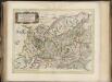
Scotiae provinciae mediterraneae inter Taum flumen et Vararis aestuarium : Sunt autem Braid-Allaban, Atholia, Marria Superior, Badenocha, Strath-Spea, Lochabria, cum Chersoneso qui ei ad occasum pra
Gordon, Robert, 1580-1661 Blaeu, Joan, 1596-1673
Scotiæ provinciæ mediterraneæ inter Taum flumen | et Vararis æstuarium: Sunt autem | BRAID-ALLABAN, ATHOLIA, MARRIA SVPERIOR. | BADENOCHA, STRATH-SPEA, LOCHABRIA, | cum Chersoneso qui ei ad occasum prætenditur; | cum singulis earundem partibus. [=] a Description of the inland provinces of SCOTLAND lying | betueen Tay river and Murra fyrth, conteyning | BRAID-ALLABAN, ATHOL, BRAE OF MAR, BADENOCH, STRATH-SPEY, LOCHABYR, | wt al ye lands which ley west from LOCHABYR wt all thair | parts conteyned under them.
Opera Ro. Gordonii a Straloch. [Amsterdam : Joan Blaeu]
Ardnamurchan to Summer Isles, including the Inner Channel and part of the Minch.
Great Britain. Hydrographic Office
Composite: Argyllshire.
1 : 175000 Thomson, John
Southern Part of Inverness Shire.
Thomson, John, 1777- ca. 1840 Johnson, William, fl. 1806-1840
Northern Part of Inverness Shire.
Thomson, John, 1777- ca. 1840 Johnson, William, fl. 1806-1840
Northern Part of Inverness Shire.
Thomson, John, 1777- ca. 1840 Johnson, William, fl. 1806-1840
Southern Part of Inverness Shire.
Thomson, John, 1777- ca. 1840 Johnson, William, fl. 1806-1840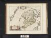
Mula Insula, quae ex Aebudarum numero una est, et Lochabriae ad occasum praetenditur. The Yle of Mul whiche is one of the Westerne Yles, and lyeth ovir against Lochabyr / Auct. Timoth. Pont.
Pont, Timothy, 1560?-1614? Blaeu, Joan, 1596-1673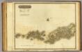
Western Isles S.
1 : 106000 Thomson, John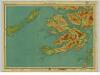
Mull & Iona, Sheet 10 - Bartholomew's "Half Inch to the Mile Maps" of Scotland
1 : 126720 Topographic maps John Bartholomew & Son, Ltd John Bartholomew & Son, Ltd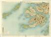
Mull, Sheet 10 - Bartholomew's "Half Inch to the Mile Maps" of Scotland
1 : 126720 Topographic maps Bartholomew, John George John Bartholomew & Co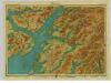
Argyll, Sheet 11 - Bartholomew's "Half Inch to the Mile Maps" of Scotland
1 : 126720 Topographic maps John Bartholomew & Son, Ltd John Bartholomew & Son, Ltd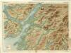
Oban & Loch Awe, Sheet 11 - Bartholomew's "Half Inch to the Mile Maps" of Scotland
1 : 126720 Topographic maps Bartholomew, John George John Bartholomew & Co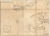
The west side of the island Mull with the islands Tiri and Coll.
Mackenzie, Murdoch (Senior), 1712-1797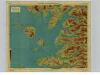
Arisaig & Rum, Sheet 14 - Bartholomew's "Half Inch to the Mile Maps" of Scotland
1 : 126720 Topographic maps John Bartholomew & Son, Ltd John Bartholomew & Son, Ltd
Mallaig, Sheet 14 - Bartholomew's "Half Inch to the Mile Maps" of Scotland
1 : 126720 Topographic maps Bartholomew, John George John Bartholomew & Co
Mvla insvla
1 Karte : Kupferdruck ; 41 x 53 cm Blaeu; Pont Joan Blaeu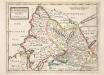
The West Part of Inverness Sh. Lochaber with all the Territories west from it / by H. Moll.
Moll, Herman, d. 1732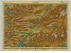
Lochaber, Sheet 15 - Bartholomew's "Half Inch to the Mile Maps" of Scotland
1 : 126720 Topographic maps John Bartholomew & Son, Ltd John Bartholomew & Son, Ltd
![Lochabria, omnesque Insulae versus Occidentem sitae, ut Uisto, Mulla, aliaeque. [Karte], in: Novus atlas absolutissimus, Bd. 8, S. 172.](https://images-2.georeferencer.com/images/iiif/090821452629/full/,300/0/native.jpg)

