Maps of Baltic Plains

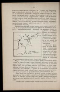
K vojně so Švecīej 1808 - 1809 gg.
Schweden Seeschlacht Russisch-Schwedischer Krieg <1808-1809>
Pas-caart van de Oost Zee
1 Karte : Kupferdruck ; 43 x 55 cm Doncker by Hendrick Doncker boekverkoper en graadbooghmaker inde Nieuwbrug-steegh in 't Stuurmans gereedtschap
[125][128] Mare Balticum, uit: Atlas sive Descriptio terrarum orbis
Annotatie: Gedigitaliseerde versie. Amsterdam. Heiloo : Picturae (vervaardiger), 2015. tiff-bestand. Gedigitaliseerd: 07-01-2015; Origineel: Universiteitsbibliotheek Vrije Universiteit (XL.05127.-) ; Netherlands; Titelpagina ontbreekt Wit, Frederik de Amsterdam : Frederick de Wit
Mare Balticum
1 Karte : Kupferdruck ; 49 x 57 cm Renard gedruckt by L. Renard
Pascaart vande Oost-Zee [...] Tabula Hydrographica Baltici [...] [Karte], in: Novus atlas absolutissimus, Bd. 9, S. 179.
1 Karte aus Atlas Janssonius Offizin
Karta pochodov galernago flota 1712 - 1721 gg.
Ostsee Nordischer Krieg <1700-1721> Seeschlacht Galeere
Pascaart Vande Oost-Zeeertoonende in sich, alle gelegentheden van Custen van Denemarcken, Sweden, Pomeren, Pruyssen, Courlant. Lyflant en Finlant [...] [Karte], in: Het vijfde Deel Des Grooten Atlas : Vervatende De Water-Weereld, S. 134.
1 Karte aus Atlas Jansson, Jan Jansson, Jan
Courones du nord 2.
1 : 2500000 Covens et Mortier
No.19. Karta Evropeyskaia Rossiia. Sheet 5
1 : 2000000 Shokalskago,Iu. M.
Uebersichtskarte von der Ost - See und den anliegenden Ländern

Baltic Sea.
1 : 3400000 Faden, William, 1750?-1836
Basin of the Baltic.
1 : 2400000 Johnston, W. & A.K.
Baltic.
1 : 4400000 Johnston, Alexander Keith, 1804-1871
Denmark Sweden and Russia on the Baltic.
1 : 3380000 Sharpe, J.
[Evropa]
Evropa
Basin of the Baltic.
1 : 2400000 Johnston, Alexander Keith
Accurate geographische Vorstellung der Ost-See
1 Karte : Kupferdruck ; 41 x 58 cm Riegel verlegt beÿ Christoph Riegel Buch- und Kunsthändlern
Nieuwe caart van de Oost Zee
1 Karte : Kupferdruck ; 58 x 85 cm chez Jean Cóvens et Corneille Mortier
Carte de la mer Baltique
1 Karte : Kupferdruck ; 60 x 88 cm Jaillot; Loon s.n.
Basin of the Baltic.
1 : 2400000 Johnston, Alexander Keith
Ostsee-Laender von der Oder bis zur Newa
Stieler's Hand-Atlas Stieler, Adolf bei Justus Perthes
Die Ostsee
Grosser Hand-Atlas über alle Theile der Erde in 170 Karten Meyer, J. Verlag des Bibliographischen Instituts
G. Freytags Übersichtskarte des deutsch-russischen Kriegsschauplatzes
1 : 2000000 Německo Kartogr. Anstalt G. Freytag & Berndt
Nord- und Ostseeherrschaft IV
1 : 7000000 Ostseeraum, Polen-Litauen, Deutscher Orden
Ostsee.
1 : 2150000 Radefeld, Carl Christian Franz, 1788-1874
Baltic States & East Prussia.
1 : 2000000 John Bartholomew and Son
Voenno-dorožnaja karta časti Rossii i pograničnych zemelʹ
1 : 1680000 Baltikum, Ostpreußen Šubert [Generalmajor]
Pas-Caart van de Oost Zee Verthonede Alle de gelegentheydt tusschen 't Eylandt Rugen ende Wyburg [Karte in 2 Teilen], in: De Nieuwe Groote Vermeerderde Zee-Atlas ofte Water-Werelt, S. 25.
1 Karte aus Atlas Doncker, Hendrick
Nord- und Ostseeherrschaft II: Reich Waldemars II.
1 : 10000000 Ostseeraum Valdemar II., Danmark, Konge