Maps of Sweden

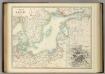
Karta pochodov galernago flota 1712 - 1721 gg.
Ostsee Nordischer Krieg <1700-1721> Seeschlacht Galeere
Die Ost See
1 : 500000 Baltské moře-oblast Flemming, Carl C. Flemming
Die Ost See
1 : 5000000 Baltské moře-oblast Flemming, Carl C. Flemming
Baltic Sea.
1 : 3400000 Faden, William, 1750?-1836
Mare Balticum
1 Karte : Kupferdruck ; 49 x 57 cm Renard gedruckt by L. Renard
No.19. Karta Evropeyskaia Rossiia. Sheet 5
1 : 2000000 Shokalskago,Iu. M.
Baltic Sea.
1 : 5000000 Philip, George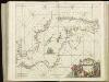
[125][128] Mare Balticum, uit: Atlas sive Descriptio terrarum orbis
Annotatie: Gedigitaliseerde versie. Amsterdam. Heiloo : Picturae (vervaardiger), 2015. tiff-bestand. Gedigitaliseerd: 07-01-2015; Origineel: Universiteitsbibliotheek Vrije Universiteit (XL.05127.-) ; Netherlands; Titelpagina ontbreekt Wit, Frederik de Amsterdam : Frederick de Wit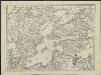
Kriegscarte zwischen Schweden und Rusland
nach den besten Carten gezeichnet von I.C. Iaeger Frankf. a/m : im Verlag der Jägerishen Landcarten Handlung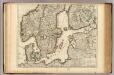
Courones du Nord (sud)
1 : 2600000 L'Isle, Guillaume de, 1675-1726
Pas-caart van de Oost Zee
1 Karte : Kupferdruck ; 43 x 55 cm Doncker by Hendrick Doncker boekverkoper en graadbooghmaker inde Nieuwbrug-steegh in 't Stuurmans gereedtschap
Pascaart vande Oost-Zee [...] Tabula Hydrographica Baltici [...] [Karte], in: Novus atlas absolutissimus, Bd. 9, S. 179.
1 Karte aus Atlas Janssonius Offizin
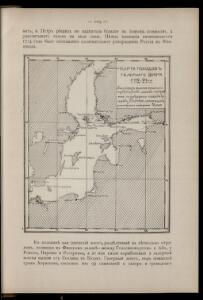
K vojně so Švecīej 1808 - 1809 gg.
Schweden Seeschlacht Russisch-Schwedischer Krieg <1808-1809>
Ice Chart, Baltic Sea, February.
U.S. Navy
Ice Chart, Baltic Sea, November.
U.S. Navy
Ice Chart, Baltic Sea, March.
U.S. Navy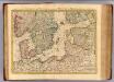
Courones du nord 2.
1 : 2500000 Covens et Mortier
Ice Chart, Baltic Sea, December.
U.S. Navy
Ice Chart, Baltic Sea, June.
U.S. Navy
Pascaart Vande Oost-Zeeertoonende in sich, alle gelegentheden van Custen van Denemarcken, Sweden, Pomeren, Pruyssen, Courlant. Lyflant en Finlant [...] [Karte], in: Het vijfde Deel Des Grooten Atlas : Vervatende De Water-Weereld, S. 134.
1 Karte aus Atlas Jansson, Jan Jansson, Jan
Ice Chart, Baltic Sea, October.
U.S. Navy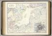
Baltic.
1 : 4400000 Johnston, Alexander Keith, 1804-1871
Ice Chart, Baltic Sea, April.
U.S. Navy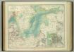
Basin of the Baltic.
1 : 2400000 Johnston, W. & A.K.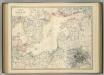
Basin of the Baltic.
1 : 2400000 Johnston, Alexander Keith
Ice Chart, Baltic Sea, January.
U.S. Navy
Ice Chart, Baltic Sea, May.
U.S. Navy
Charta öfver Sverige
1 : 6500000 utg. en 1789 af Fredr. Akrel förbättrad af Dan. Djurberg Stockholm : [s.n.]
Uebersichtskarte von der Ost - See und den anliegenden Ländern