Maps of Belarus
Voenno-dorožnaja karta časti Rossii i pograničnych zemelʹ
1 : 1680000 Baltikum, Ostpreußen Šubert [Generalmajor]
Ostmitteleuropa 1772
Ostmitteleuropa Kunz, Andreas ; Treiling, Thomas
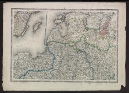
Ostsee-Laender und Inneres Russland bis Moskau
Hand-Atlas über alle Theile der Erde nach dem neuesten Zustande und über das Weltgebäude Stieler, Adolf bei Justus Perthes
Ostsee-Laender und Inneres Russland bis Moskau
Hand-Atlas über alle Theile der Erde nach dem neuesten Zustande und über das Weltgebäude Stieler, Adolf bei Justus Perthes
[Evropa]
Evropa
Ostsee-Laender und inneres Russland bis Moskau
1 : 3700000 Moskva-oblast (Rusko) Stülpnagel, Friedrich von Ausfeld, Johann Carl Justus Perthes
Ostsee-Laender und inneres Russland bis Moskau
1 : 3700000 Moskva-oblast (Rusko) Stülpnagel, Friedrich von Ausfeld, Johann Carl Justus Perthes
Ostmitteleuropa 1830
Ostmitteleuropa Kunz, Andreas ; Röss, Wolf ; Johnen, Bettina ; Moeschl, Joachim Robert
Ostmitteleuropa 1867
Ostmitteleuropa Kunz, Andreas ; Röss, Wolf ; Johnen, Bettina ; Moeschl, Joachim Robert
Ostmitteleuropa 1914
Ostmitteleuropa Kunz, Andreas ; Röss, Wolf ; Johnen, Bettina ; Moeschl, Joachim Robert
Ostmitteleuropa 1921
Ostmitteleuropa Kunz, Andreas ; Treiling, Thomas
Ostmitteleuropa 1937
Ostmitteleuropa Kunz, Andreas ; Treiling, Thomas
Ostmitteleuropa 1923
Ostmitteleuropa Kunz, Andreas ; Treiling, Thomas
Ostmitteleuropa 1846
Ostmitteleuropa Kunz, Andreas ; Röss, Wolf ; Johnen, Bettina ; Moeschl, Joachim Robert
Ostsee-Laender von der Oder bis zur Newa
Stieler's Hand-Atlas Stieler, Adolf bei Justus Perthes
Ostmitteleuropa 1820
Ostmitteleuropa Kunz, Andreas ; Röss, Wolf ; Johnen, Bettina ; Moeschl, Joachim Robert
Baltic States & East Prussia.
1 : 2000000 John Bartholomew and Son
Ostmitteleuropa 1809
Ostmitteleuropa Kunz, Andreas ; Treiling, Thomas
Ostmitteleuropa 1807
Ostmitteleuropa Kunz, Andreas ; Treiling, Thomas
Ostmitteleuropa 1793
Ostmitteleuropa Kunz, Andreas ; Treiling, Thomas
Ostmitteleuropa 1871
Ostmitteleuropa Kunz, Andreas ; Röss, Wolf ; Johnen, Bettina ; Moeschl, Joachim Robert
Mare Balticum
1 Karte : Kupferdruck ; 49 x 57 cm Renard gedruckt by L. Renard
Dietrich Reimer's Kriegsstandskarten. 1. 1500000, Der Kreig gegen Russland und der Kampf um die Dardanellen
1 : 1500000 Wo Stehen Unsere Armeen in Russland? 6 Ausg.,abgeschlossen am 27. Sept.1915 Dietrich Reimer Verlag Berlin : Dietrich Reimer Ernst Vohsen
Basin of the Baltic.
1 : 2400000 Johnston, W. & A.K.
Kriegs Atlas 36 Karten von den Schauplätzen des Weltkrieges 1914/1915

Ostmitteleuropa 1795
Ostmitteleuropa Kunz, Andreas ; Treiling, Thomas
Deutsch-österreichisch-russische Grenzlande
1 : 2000000 Evropa východní Velhagen & Klasing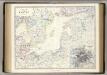
Baltic.
1 : 4400000 Johnston, Alexander Keith, 1804-1871
Nord- und Ostseeherrschaft IV
1 : 7000000 Ostseeraum, Polen-Litauen, Deutscher Orden