Maps of Poland

Ostsee-Laender von der Oder bis zur Newa
Stieler's Hand-Atlas Stieler, Adolf bei Justus Perthes
G. Freytags Übersichtskarte des deutsch-russischen Kriegsschauplatzes
1 : 2000000 Německo Kartogr. Anstalt G. Freytag & Berndt
[Evropa]
Evropa
[Kaart], uit: G. Freytags Übersichtskarte des Deutsch-Russischen Kriegsschauplatzes
1 : 2000000 titelvariant: Übersichtskarte des Deutsch-Russischen Kriegsschauplatzes; Annotatie: Omslagtitel: Übersichtskarte des Deutsch-Russischen Kriegsschauplatzes Freytag, G. Wien : Freytag & Berndt
[Ost-Europa in 6 Blättern, Enthaltend: Norwegen, Schweden, Russland, Kaukasien und die Türkei, Blatt 3]
Hand-Atlas über alle Theile der Erde und über das Weltgebäude Stieler, Adolf Justus Perthes
[Ost-Europa, Blatt 3]
Adolf Stieler's Handatlas über alle Theile der Erde und über das Weltgebäude Stieler, Adolf Justus Perthes
Ostmitteleuropa 2003
Ostmitteleuropa Kunz, Andreas ; Treiling, Thomas
Ostmitteleuropa 1991
Ostmitteleuropa Kunz, Andreas ; Treiling, Thomas
Ostmitteleuropa 1949
Ostmitteleuropa Kunz, Andreas ; Treiling, Thomas
Ostmitteleuropa 1989
Ostmitteleuropa Kunz, Andreas ; Treiling, Thomas
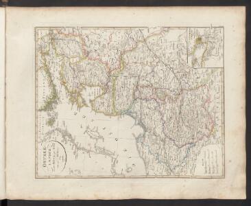
Carte von Polen und einen grossen Theil der angrenzenden Laender
1 : 1300000 Evropa střední a východní Rendziny, Stanislaus Gilly Tranquillo Mollo
Regni Poloniae et ducatus Lithvaniae Voliniae, Podoliae Vcraniae Prvssiae, Livoniae et Cvrlandiae / descriptio emendata per F. de Wit Amstelodami
1 : 3000000 Annotatie: Rechtsboven: 14; Origineel is Blad 132 in atlas factice; Annotatie geografische gegevens: Met schaalstok: 15 Duytsche Mylen Frederick de Wit 1630-1706 [Amsterdam : F. de Wit]
[Ost-Europa in 6 Blättern, Blatt 3]
Handatlas über alle Theile der Erde und über das Weltgebäude Stieler, Adolf Justus Perthes
Ostmitteleuropa 1815
Ostmitteleuropa Kunz, Andreas ; Johnen, Bettina ; Moeschl, Joachim Robert
Ostmitteleuropa 1830
Ostmitteleuropa Kunz, Andreas ; Röss, Wolf ; Johnen, Bettina ; Moeschl, Joachim Robert
Ostdeutschland - Westrußland - Nordösterreich
1 : 1500000 Evropa východní Mittelbachs Verlag
Ostmitteleuropa 1937
Ostmitteleuropa Kunz, Andreas ; Treiling, Thomas
Ostmitteleuropa 1809
Ostmitteleuropa Kunz, Andreas ; Treiling, Thomas
Deutsch-österreichisch-russische Grenzlande
1 : 2000000 Evropa východní Velhagen & Klasing
Ostmitteleuropa 1923
Ostmitteleuropa Kunz, Andreas ; Treiling, Thomas
Ostmitteleuropa 1914
Ostmitteleuropa Kunz, Andreas ; Röss, Wolf ; Johnen, Bettina ; Moeschl, Joachim Robert
Deutsch-russische Grenzlande
1 : 2000000 Evropa východní Velhagen & Klasing
Ostmitteleuropa 1846
Ostmitteleuropa Kunz, Andreas ; Röss, Wolf ; Johnen, Bettina ; Moeschl, Joachim Robert
Ostmitteleuropa 1807
Ostmitteleuropa Kunz, Andreas ; Treiling, Thomas
Ostmitteleuropa 1867
Ostmitteleuropa Kunz, Andreas ; Röss, Wolf ; Johnen, Bettina ; Moeschl, Joachim Robert
Ostmitteleuropa 1793
Ostmitteleuropa Kunz, Andreas ; Treiling, Thomas
Ostmitteleuropa 1921
Ostmitteleuropa Kunz, Andreas ; Treiling, Thomas
Ostmitteleuropa 1871
Ostmitteleuropa Kunz, Andreas ; Röss, Wolf ; Johnen, Bettina ; Moeschl, Joachim Robert
Regni Poloniae Magnique Ducat[us] Lithuaniae Nova et exacta Tabula
1 : 3000000 Homann, Johann Baptist
Regnum Poloniae eiusque confinia
1 : 11100000 1 Karte : Kupferdruck ; 13 x 17 cm Weigel, Johann Christoph [Johann Christoph Weigel]