Maps of Poland

[Ost-Europa, Blatt 3]
Adolf Stieler's Handatlas über alle Theile der Erde und über das Weltgebäude Stieler, Adolf Justus Perthes
[Ost-Europa in 6 Blättern, Blatt 3]
Handatlas über alle Theile der Erde und über das Weltgebäude Stieler, Adolf Justus Perthes
[Ost-Europa in 6 Blättern, Enthaltend: Norwegen, Schweden, Russland, Kaukasien und die Türkei, Blatt 3]
Hand-Atlas über alle Theile der Erde und über das Weltgebäude Stieler, Adolf Justus Perthes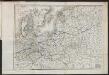
Carte du Théâtre de la Guerre en Russie et en Allemagne pendant 1812 et 1813
Russland, Deutschland, Befreiungskriege <1813-1815>
Kirchenprovinzen Gnesen, Riga u. Lemberg XV. Jahrh.
1 : 24000000 Ostmitteleuropa Kirchenprovinz
Part of North of Europe.
1 : 3800000 Melish, John
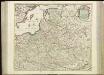
Ost-Europa, No. 3: Sud-Schweden, die Russischen Ostsee-Provinzen, Polen & West-Russland.
1 : 3700000 Petermann, A.
Poland.
from Carey's general atlas, improved and enlarged : being a collection of maps of the world and quarters, their principal empires, kingdoms, &c.
Kirchenprovinzen Gnesen u. Riga im XIII. Jahrh.
1 : 24000000 Gniezno, Riga, Kirchenprovinz
Oostelijk operatietooneel
1 : 2250000 Annotatie geografische gegevens: Legenda Den Haag : J. Smulders & Co.
Téatre De La Guerre Des Couronnes du Nord. [Karte], in: Atlas nouveau, contenant toutes les parties du monde [...], Bd. 1, S. 67.
1 Karte aus Atlas Sanson, Nicolas Jaillot, Alexis Hubert und Mortier, Pieter
Die Ältesten Karten von Deutschland

[71][71] Regni Poloniae et Ducatus Lithuaniae ..., uit: Atlas sive Descriptio terrarum orbis
Annotatie: Gedigitaliseerde versie. Amsterdam. Heiloo : Picturae (vervaardiger), 2015. tiff-bestand. Gedigitaliseerd: 07-01-2015; Origineel: Universiteitsbibliotheek Vrije Universiteit (XL.05127.-) ; Netherlands; Titelpagina ontbreekt Wit, Frederik de Amsterdam : Frederick de Wit
[Kaart], uit: G. Freytags Übersichtskarte des Deutsch-Russischen Kriegsschauplatzes
1 : 2000000 titelvariant: Übersichtskarte des Deutsch-Russischen Kriegsschauplatzes; Annotatie: Omslagtitel: Übersichtskarte des Deutsch-Russischen Kriegsschauplatzes Freytag, G. Wien : Freytag & Berndt
G. Freytags Übersichtskarte des deutsch-russischen Kriegsschauplatzes
1 : 2000000 Německo Kartogr. Anstalt G. Freytag & Berndt
Nord- und Ostseeherrschaft III
1 : 10000000 Ostseeraum, Deutscher Orden, Deutsche Hanse

Partitions of Poland. 1918
1 : 4000000 Partitions of Poland. 1918. Partitions of 1772, 1793, 1795. Russia, Prussia, Austria. War Office
Ostmitteleuropa 1815
Ostmitteleuropa Kunz, Andreas ; Johnen, Bettina ; Moeschl, Joachim Robert
Carte von Polen und einen grossen Theil der angrenzenden Laender
1 : 1300000 Evropa střední a východní Rendziny, Stanislaus Gilly Tranquillo Mollo
Übersichtskarte des Östlichen Kriegsschauplatzes
1 : 6000000 Osteuropa Weltkrieg <1914-1918> Verl. Gerhard Stalling, Oldenburg
Regnum Poloniae eiusque confinia
1 : 11100000 1 Karte : Kupferdruck ; 13 x 17 cm Weigel, Johann Christoph [Johann Christoph Weigel]
Reise Charte durch das Königreich Polen mit allen darzu gehörigen Laendern / verfertiget von JG. S
1 : 9300000 1 Karte : Kupferdruck ; 16 x 21 cm, Bildgr. 17 x 25 cm Schreiber, Johann Georg [J. G. Schreiber]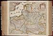
Regni Poloniae et ducatus Lithvaniae Voliniae, Podoliae Vcraniae Prvssiae, Livoniae et Cvrlandiae / descriptio emendata per F. de Wit Amstelodami
1 : 3000000 Annotatie: Rechtsboven: 14; Origineel is Blad 132 in atlas factice; Annotatie geografische gegevens: Met schaalstok: 15 Duytsche Mylen Frederick de Wit 1630-1706 [Amsterdam : F. de Wit]
Ostmitteleuropa 1989
Ostmitteleuropa Kunz, Andreas ; Treiling, Thomas

Polska za Mieczyslawa I
Polsko
Volker und Reiche der Slaven zwischen Elbe und Don bis 1125.
1 : 5000000 Spruner von Merz, Karl
![[Ost-Europa, Blatt 3]](https://images-2.georeferencer.com/images/iiif/368095765416/full/,300/0/native.jpg)

