Maps of Poland


Homannův atlas světa
1 : 400000
[71][71] Regni Poloniae et Ducatus Lithuaniae ..., uit: Atlas sive Descriptio terrarum orbis
Annotatie: Gedigitaliseerde versie. Amsterdam. Heiloo : Picturae (vervaardiger), 2015. tiff-bestand. Gedigitaliseerd: 07-01-2015; Origineel: Universiteitsbibliotheek Vrije Universiteit (XL.05127.-) ; Netherlands; Titelpagina ontbreekt Wit, Frederik de Amsterdam : Frederick de Wit
Polen und Litthauen unter den Jagjellonen 1386-1572.
1 : 5000000 Spruner von Merz, Karl
Volker und Reiche der Slaven zwischen Elbe und Don bis 1125.
1 : 5000000 Spruner von Merz, Karl
Geologičeskaja karta Evropejskoj Rossii
1 : 2500000 Westblatt Karpinskij, A.P. (Aleksandr Petrovič) Kartografičeskoe zavedenie A.Il'ina
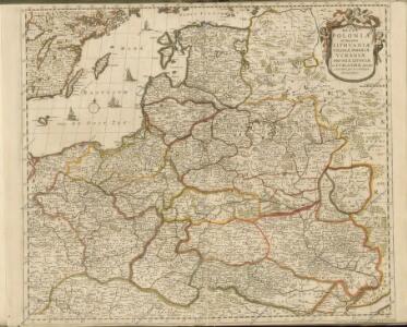
Regni Poloniae et ducatus Lithvaniae Voliniae, Podoliae Vcraniae Prvssiae, Livoniae et Cvrlandiae / descriptio emendata per F. de Wit Amstelodami
1 : 3000000 Annotatie: Rechtsboven: 14; Origineel is Blad 132 in atlas factice; Annotatie geografische gegevens: Met schaalstok: 15 Duytsche Mylen Frederick de Wit 1630-1706 [Amsterdam : F. de Wit]
Polen nach der dritten Theilung 1795
1 : 20000000 Polen Teilung Polens <1795>
Polen und Litthauen 1125-1386.
1 : 5000000 Spruner von Merz, Karl
Polen nach der zweiten Theilung 1793
1 : 20000000 Polen Teilung Polens <1793>
Polen nach der ersten Theilung 1772
1 : 20000000 Polen Teilung Polens <1772>
Polen vor dem Frieden v. Andrussow 1667
1 : 20000000 Polen-Litauen Russisch-polnischer Krieg <1654-1667>
Regni Poloniae Magniquae Ducatus Lithuaniae Nova et exacta tabula
1 : 3000000 Litva Homann, Johann Baptist Starowolski, Szymon a Ioh. Bapt. Homanno
Ostdeutschland - Westrußland - Nordösterreich
1 : 1500000 Evropa východní Mittelbachs Verlag
Carte du Théâtre de la Guerre en Russie et en Allemagne pendant 1812 et 1813
Russland, Deutschland, Befreiungskriege <1813-1815>
Polen und Litthauen nach der Lubliner Union 1569 und dem Aussterben der Jagiellonen 1572
1 : 12000000 Polen-Litauen
Neberts Kriegs - Frontenkarte von allen Kriegsschauplätzen No 2

Regni Poloniae Magnique Ducat[us] Lithuaniae Nova et exacta Tabula
1 : 3000000 Homann, Johann Baptist
Regni Poloniae Magnique Ducatus Lithuaniae Nova et exacta Tabula ad mentem Starovolcii descripta à Ioh. Bapt. Homanno Sac. Caes. Mai. Geographo
Polen, Litauen Homann, Johann Baptist
Regni Poloniae et Ducatus Lithuaniae Voliniae, Podoliae Ucraniae Prussiae, Livoniae et Curlandiae descriptio [Karte], in: Novus atlas absolutissimus, Bd. 1, S. 93.
1 Karte aus Atlas Janssonius Offizin
Reipublicae et status generalis Poloniae nova tabula, comprehendens Majoris et Minoris Poloniae Regni, Magni Ducatus Lithuaniae, Ducatus Prussiae, Curlandiae, Russiae Ucraniae, Massoviae, Volhyniae et Podoliae, accuratam descriptionem
Polen, Großfürstentum Litauen de Wit, Frederik, http://d-nb.info/gnd/11931648X
Polonia regnum ut et magni ducat. Lithuaniae accuratiss. delin
1 : 6470000 Bělorusko Seutter, Matthäus Lotter, Tobias Conrad bey Tob. Conr. Lotter
[Geschichtlich-geographische Entwickelung des Zuwachses und der Abnahme des polnischen Reiches vom Jahre 992 bis zum Jahre 1831, dargestellt in fünf Karten] : V. Karte der Wiederherstellung Polens, 1807-1831
1 : 4800000 entw. u. gez. durch F.A. von Witzleben [Berlin] : [Reimer]
Polen vom Anfange des XVIII Jahrhunderts bis zum Untergange der Republik 1795
1 : 5000000 Polen-Litauen, Teilungen Polens
Poland.
from Carey's general atlas, improved and enlarged : being a collection of maps of the world and quarters, their principal empires, kingdoms, &c.
Polska za Władysława Łokietka roku 1333
Evropa jihovýchodní
Lechia za Bolesława Wstydliwego roku 1279
Evropa jihovýchodní
Polska czyli Lechia od Bolesława Krzywoustego między synów podzielona roku 1139
Evropa jihovýchodní