Maps of Ukraine

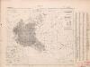
Volker und Reiche der Slaven zwischen Elbe und Don bis 1125.
1 : 5000000 Spruner von Merz, Karl
Polen und Litthauen unter den Jagjellonen 1386-1572.
1 : 5000000 Spruner von Merz, Karl
Polen nach der dritten Theilung 1795
1 : 20000000 Polen Teilung Polens <1795>
Polen nach der zweiten Theilung 1793
1 : 20000000 Polen Teilung Polens <1793>
Polen nach der ersten Theilung 1772
1 : 20000000 Polen Teilung Polens <1772>
[71][71] Regni Poloniae et Ducatus Lithuaniae ..., uit: Atlas sive Descriptio terrarum orbis
Annotatie: Gedigitaliseerde versie. Amsterdam. Heiloo : Picturae (vervaardiger), 2015. tiff-bestand. Gedigitaliseerd: 07-01-2015; Origineel: Universiteitsbibliotheek Vrije Universiteit (XL.05127.-) ; Netherlands; Titelpagina ontbreekt Wit, Frederik de Amsterdam : Frederick de Wit
Polen vor dem Frieden v. Andrussow 1667
1 : 20000000 Polen-Litauen Russisch-polnischer Krieg <1654-1667>
Regni Poloniae Magniquae Ducatus Lithuaniae Nova et exacta tabula
1 : 3000000 Litva Homann, Johann Baptist Starowolski, Szymon a Ioh. Bapt. Homanno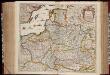
Regni Poloniae et ducatus Lithvaniae Voliniae, Podoliae Vcraniae Prvssiae, Livoniae et Cvrlandiae / descriptio emendata per F. de Wit Amstelodami
1 : 3000000 Annotatie: Rechtsboven: 14; Origineel is Blad 132 in atlas factice; Annotatie geografische gegevens: Met schaalstok: 15 Duytsche Mylen Frederick de Wit 1630-1706 [Amsterdam : F. de Wit]
Polska za Stefana Batorego roku 1586
Evropa jihovýchodní
Polska za Mieczysława I. roku 992
Evropa jihovýchodní
Polska za Kazimirza Wielkiego roku 1370
Evropa jihovýchodní
Sławiańszczyzna przed powstaniem Polski roku 850
Evropa jihovýchodní
Polska za Jana Alberta roku 1500
Evropa jihovýchodní
Polska za Jana Kazimirza i za Michała Wisniowieckiego 1673, klęski od roku 1648 do 1717
Evropa jihovýchodní
Polska za Zygmunta Augusta roku 1572
Evropa jihovýchodní
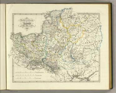
Polska za Stanisława Augusta podzielona 1772, 1793, 1795
Evropa jihovýchodní
Polska za Bolesława Wielkiego roku 1025
Evropa jihovýchodní
Polen und Litthauen 1125-1386.
1 : 5000000 Spruner von Merz, Karl
Polen und Litthauen nach der Lubliner Union 1569 und dem Aussterben der Jagiellonen 1572
1 : 12000000 Polen-Litauen
[Geschichtlich-geographische Entwickelung des Zuwachses und der Abnahme des polnischen Reiches vom Jahre 992 bis zum Jahre 1831, dargestellt in fünf Karten] : V. Karte der Wiederherstellung Polens, 1807-1831
1 : 4800000 entw. u. gez. durch F.A. von Witzleben [Berlin] : [Reimer]
Poland: Poles (excluding Jews)
1 : 3000000 Series of maps on various aspects of Poland. Poles (excluding Jews). Kingdom of Poland (1897) an Galicia (1900). Distribution of Poles, showing minorities. War Office

Polen vom Anfange des XVIII Jahrhunderts bis zum Untergange der Republik 1795
1 : 5000000 Polen-Litauen, Teilungen Polens
Poland: Language. No.1
1 : 3000000 Series of maps on various aspects of Poland. Languages in 1910-1913. War Office
Kirchenprovinzen Gnesen u. Riga im XIII. Jahrh.
1 : 24000000 Gniezno, Riga, Kirchenprovinz
Polen bis zu seinem Untergange 1795.
1 : 5000000 Spruner von Merz, Karl
Regni Poloniae Magnique Ducatus Lithuaniae Nova et exacta Tabula ad mentem Starovolcii descripta à Ioh. Bapt. Homanno Sac. Caes. Mai. Geographo
Polen, Litauen Homann, Johann Baptist
[Geschichtlich-geographische Entwickelung des Zuwachses und der Abnahme des polnischen Reiches vom Jahre 992 bis zum Jahre 1831, dargestellt in fünf Karten] : II. Karte von Polen unter dem Jagellonen, 1386-1572
1 : 4800000 entw. u. gez. durch F.A. von Witzleben [Berlin] : [Reimer]