Maps of Poland
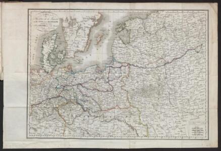
Carte du Théâtre de la Guerre en Russie et en Allemagne pendant 1812 et 1813
Russland, Deutschland, Befreiungskriege <1813-1815>
Poland.
from Carey's general atlas, improved and enlarged : being a collection of maps of the world and quarters, their principal empires, kingdoms, &c.
Poland.
from A new systeme of the mathematicks: containing I. Arithmetick, as well natural and decimal, as in species, or the principles of algebra. II. Practical geometry, together with the first six books of Euclid's Elements, as also the eleventh and twelfth, symbo
Kirchenprovinzen Gnesen, Riga u. Lemberg XV. Jahrh.
1 : 24000000 Ostmitteleuropa Kirchenprovinz
Kirchenprovinzen Gnesen u. Riga im XIII. Jahrh.
1 : 24000000 Gniezno, Riga, Kirchenprovinz
Volker und Reiche der Slaven zwischen Elbe und Don bis 1125.
1 : 5000000 Spruner von Merz, Karl
Polen und Litthauen unter den Jagjellonen 1386-1572.
1 : 5000000 Spruner von Merz, Karl
Svět staroslovanský
Evropa střední a východní Milbauer, Emanuel Vlastimil Šafařík, Pavel Josef
[Ost-Europa in 6 Blättern, Blatt 3]
Handatlas über alle Theile der Erde und über das Weltgebäude Stieler, Adolf Justus Perthes

Polska za Stefana Batorego roku 1586
Evropa jihovýchodní
Polska za Mieczysława I. roku 992
Evropa jihovýchodní
Polska za Kazimirza Wielkiego roku 1370
Evropa jihovýchodní
Sławiańszczyzna przed powstaniem Polski roku 850
Evropa jihovýchodní
Polska za Jana Alberta roku 1500
Evropa jihovýchodní
Polska za Jana Kazimirza i za Michała Wisniowieckiego 1673, klęski od roku 1648 do 1717
Evropa jihovýchodní
Polska za Zygmunta Augusta roku 1572
Evropa jihovýchodní
Polska za Stanisława Augusta podzielona 1772, 1793, 1795
Evropa jihovýchodní
Polska za Bolesława Wielkiego roku 1025
Evropa jihovýchodní
[Ost-Europa, Blatt 3]
Adolf Stieler's Handatlas über alle Theile der Erde und über das Weltgebäude Stieler, Adolf Justus Perthes
Polen nach der dritten Theilung 1795
1 : 20000000 Polen Teilung Polens <1795>
[71][71] Regni Poloniae et Ducatus Lithuaniae ..., uit: Atlas sive Descriptio terrarum orbis
Annotatie: Gedigitaliseerde versie. Amsterdam. Heiloo : Picturae (vervaardiger), 2015. tiff-bestand. Gedigitaliseerd: 07-01-2015; Origineel: Universiteitsbibliotheek Vrije Universiteit (XL.05127.-) ; Netherlands; Titelpagina ontbreekt Wit, Frederik de Amsterdam : Frederick de Wit
Regni Poloniae Magniquae Ducatus Lithuaniae Nova et exacta tabula
1 : 3000000 Litva Homann, Johann Baptist Starowolski, Szymon a Ioh. Bapt. Homanno
Polen nach der zweiten Theilung 1793
1 : 20000000 Polen Teilung Polens <1793>
Polen nach der ersten Theilung 1772
1 : 20000000 Polen Teilung Polens <1772>
Regni Poloniae Magnique Ducatus Lithuaniae Nova et exacta Tabula ad mentem Starovolcii descripta à Ioh. Bapt. Homanno Sac. Caes. Mai. Geographo
Polen, Litauen Homann, Johann Baptist
Polska za Władysława Łokietka roku 1333
Evropa jihovýchodní
Lechia za Bolesława Wstydliwego roku 1279
Evropa jihovýchodní
Polska czyli Lechia od Bolesława Krzywoustego między synów podzielona roku 1139
Evropa jihovýchodní