Maps of Poland

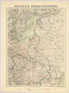
Oostelijk operatietooneel
1 : 2250000 Annotatie geografische gegevens: Legenda Den Haag : J. Smulders & Co.
Polska za Stefana Batorego roku 1586
Evropa jihovýchodní
Polska za Mieczysława I. roku 992
Evropa jihovýchodní
Polska za Kazimirza Wielkiego roku 1370
Evropa jihovýchodní
Sławiańszczyzna przed powstaniem Polski roku 850
Evropa jihovýchodní
Polska za Jana Alberta roku 1500
Evropa jihovýchodní
Polska za Jana Kazimirza i za Michała Wisniowieckiego 1673, klęski od roku 1648 do 1717
Evropa jihovýchodní
Polska za Zygmunta Augusta roku 1572
Evropa jihovýchodní
Polska za Stanisława Augusta podzielona 1772, 1793, 1795
Evropa jihovýchodní
Polska za Bolesława Wielkiego roku 1025
Evropa jihovýchodní
Německo - ruské pohraničí a Balkán

Carte Synoptique au tarif de l'Europe centrale trafic voyageurs, des bagages et des colis express

Svět staroslovanský
Evropa střední a východní Milbauer, Emanuel Vlastimil Šafařík, Pavel Josef
Polska za Władysława Łokietka roku 1333
Evropa jihovýchodní
Lechia za Bolesława Wstydliwego roku 1279
Evropa jihovýchodní
Polska czyli Lechia od Bolesława Krzywoustego między synów podzielona roku 1139
Evropa jihovýchodní
Schiffbare Wasserstrassen in Mitteleuropa
1 : 15000 Evropa střední Oelwein, A.
Poland.
from Carey's general atlas, improved and enlarged : being a collection of maps of the world and quarters, their principal empires, kingdoms, &c.
Die Ältesten Karten von Deutschland

Kirchenprovinzen Gnesen, Riga u. Lemberg XV. Jahrh.
1 : 24000000 Ostmitteleuropa Kirchenprovinz
Polen nach der dritten Theilung 1795
1 : 20000000 Polen Teilung Polens <1795>
Regnum Poloniae eiusque confinia
1 : 11100000 1 Karte : Kupferdruck ; 13 x 17 cm Weigel, Johann Christoph [Johann Christoph Weigel]
Reise Charte durch das Königreich Polen mit allen darzu gehörigen Laendern / verfertiget von JG. S
1 : 9300000 1 Karte : Kupferdruck ; 16 x 21 cm, Bildgr. 17 x 25 cm Schreiber, Johann Georg [J. G. Schreiber]
Kirchenprovinzen Gnesen u. Riga im XIII. Jahrh.
1 : 24000000 Gniezno, Riga, Kirchenprovinz
Regni Poloniae magnique ducatusq. Lithuaniae nova et exacta tabula
1 : 3130000 Bělorusko Homann, Johann Baptist Starowolski, Szymon Homannovi dědicové
REGNI POLONIAE MAGNIQUE DUCATUS LITHUANIAE Nova et exacta tabula
1 : 3200000 Bělorusko Homann, Johann Baptist Starowolski, Szymon Homannovi dědicové
Regni Poloniae magnique ducatusq. Lithuaniae nova et exacta tabula
1 : 3130000 Bělorusko Homann, Johann Baptist Starowolski, Szymon Homann Erben
Regni Poloniae magnique ducat[us] Lithuaniae nova et exacta tabula
1 : 3041000 Bělorusko Homann, Johann Baptist Starowolski, Szymon â Iohanne Bapt. Homanno
Die Länder des Grössten Völkergemisches
1 : 20000000 Ostmitteleuropa, Südosteuropa