Maps of Germany
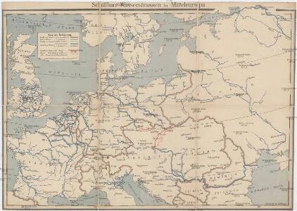
Schiffbare Wasserstrassen in Mitteleuropa
1 : 15000 Evropa střední Oelwein, A.
Map of the Post-Route to & from St. Petersburgh
1 : 24000000 Osteuropa Deutschland Polen Russland Reiseweg Postroute
Porostní mapa revíru Srbice
1 : 2880
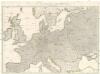
Die Karte von Europa...
Wege-Karte durch den grösten und wichtigsten Theil Europa's
Evropa Schmidt, Johann Marius Friedrich Kliewer, Heinrich Simon Schropp et Comp.
29. Mitteleuropa im Jahre 1650
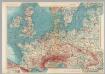
Mitteleuropa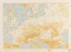
Bez titulu: Povětrnostní mapa Střední Evropy
Western Europe. Pergamon World Atlas.
1 : 5000000 Polish Army Topography Service
Carte des états slaves rendus indépendants par Samo, et groupés autour de lui (an 625 à 650), en face du royaume réduit des Avars, enserré à l’est par les Khazars et les Bulgares, et au sud et à l’ouest par les Slaves que l’empereur Héraclius avait établis au sud du Danube
Ostmitteleuropa Tschechische Republik Slawen Awaren Samo
30. Mitteleuropa nach Beendigung des nordischen Krieges im Jahre 1721
Mitteleuropa, Ostmitteleuropa, Nordischer Krieg <1700-1721>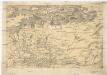
[Centralis Europae]
Evropa střední Schedel, Hartmann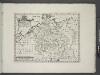
Germany.
from A new sett of maps both of antient and present geography : wherein not only the latitude and longitude of many places are corrected according to the latest observations, but also the most remarkable differences of antient and present geography may be quickly discern'd by a bare inspection or comparing of correspondent maps, which seems to be the most natural and easy method to lead young students (for whose use the work is principally intended) unto a competent knowledge of the geographical science : together with a geographical treatise particularly adapted to the use and design of these maps / by Edward Wells, M.A. and student of Christ-Church, Oxon.
Carte des chemins de fer de l'Europe, uit: Carte des chemins de fer de la Belgique
1 : 370000 [Bruxelles : Ministère des Chemins de Fer, Postes et Télégraphes]
Polen, Litthauen und das Gebiet des deutsche Ordens in den Jahren 1386 - 1480
1 : 6000000 Polen-Litauen, Preußen (Ordensstaat)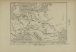
La Germanie à l’époque des invasions des Cimbres et des Teutons à travers l’Europe
Mitteleuropa Germanien Kimbern Teutonen Augustus
Quarta Europae Tabula. [Magna Germania] [Karte], in: Claudii Ptolemei viri Alexandrini mathematice discipline philosophi doctissimi geographie opus [...], S. 160.
1 Karte aus Atlas Waldseemüller, Martin [und Ptolemaeus, Claudius] Übelin, Georg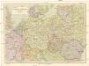
Střední Evropa
1 : 3000000 Evropa střední Kuchař, Karel Janka, Jaromír V. Neubert a synové
32. Mitteleuropa nach dem Reichsdeputationshauptschluss im Jahre 1803
Mitteleuropa Reichsdeputationshauptschluss
Die grossen Friedensschlüsse II (1735 - 1812). Frankreichs, Rußlands und Englands Vorschreiten 1801-1812
1 : 20000000 Mitteleuropa, Osteuropa, Napoleonische Kriege
[Einwanderung in Reval 1639-1710)
Reval Einwanderung Essen, Nicolai v. ; Eichhorn, Nicolai
Conspectus Generalis omnium earum partium quae unquam ad Imperium Francicum vel Franco-Romanum demum Romano-Germanicum diversis temporum periodis pertinuerunt.
1 : 11000000 Mollova mapová sbírka Homann, Johann Baptist Homann, Johann Baptista - dědici
Quarta Europe Tabula [Karte], in: [Clavdii Ptholomei Cosmographi ...], S. 260.
1 Karte aus Atlas Nicolaus Germanus [und Ptolemaeus, Claudius]
Conspectus Generalis omnium earum partium quae unquam ad Imperium Francicum vel Franco-Romanum demum Romano-Germanicum diversis temporum periodis pertinuerunt.
1 : 11000000 Mollova mapová sbírka Homann, Johann Baptist Homann, Johann Baptista - dědici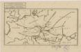
Sbírka map a diagramů použitých na mírových konferencích v Paříži v letech 1919 - 1920
Carte itinéraire de l'Europe indiquant les limites actuelles des etats
1 : 3760000 Evropa Dufour, A. H. Simonneau, Charles Ch.les Simonneau
Übersicht des Ländergebiets der Westeuropäischen Grossmächte
1 : 6000000 Evropa západní Justus Perthes
Téatre De La Guerre Des Couronnes du Nord. [Karte], in: Atlas nouveau, contenant toutes les parties du monde [...], Bd. 1, S. 67.
1 Karte aus Atlas Sanson, Nicolas Jaillot, Alexis Hubert und Mortier, Pieter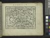
Germania.
from Abraham Ortelius his epitome of the theater of the worlde / nowe latlye ... renewed and augmented ... by Micheal Coignet, mathematitian of Antwarpe.
Poland.
from A new systeme of the mathematicks: containing I. Arithmetick, as well natural and decimal, as in species, or the principles of algebra. II. Practical geometry, together with the first six books of Euclid's Elements, as also the eleventh and twelfth, symbo