Maps of Götaland
Baltic.
1 : 4400000 Johnston, Alexander Keith, 1804-1871
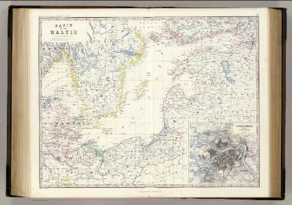
Basin of the Baltic.
1 : 2400000 Johnston, W. & A.K.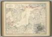
Basin of the Baltic.
1 : 2400000 Johnston, Alexander Keith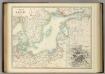
Basin of the Baltic.
1 : 2400000 Johnston, Alexander Keith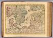
Courones du nord 2.
1 : 2500000 Covens et Mortier
Nord- und Ostseeherrschaft IV
1 : 7000000 Ostseeraum, Polen-Litauen, Deutscher Orden
Ost-Europa, No. 3: Sud-Schweden, die Russischen Ostsee-Provinzen, Polen & West-Russland.
1 : 3700000 Petermann, A.
Die Ostsee
Grosser Hand-Atlas über alle Theile der Erde in 170 Karten Meyer, J. Verlag des Bibliographischen Instituts
Mare Balticum
1 Karte : Kupferdruck ; 49 x 57 cm Renard gedruckt by L. Renard
Ostsee.
1 : 2150000 Radefeld, Carl Christian Franz, 1788-1874
Uebersichtskarte von der Ost - See und den anliegenden Ländern

Die Ost See
1 : 500000 Baltské moře-oblast Flemming, Carl C. Flemming
Die Ost See
1 : 5000000 Baltské moře-oblast Flemming, Carl C. Flemming
[Ost-Europa, Blatt 3]
Adolf Stieler's Handatlas über alle Theile der Erde und über das Weltgebäude Stieler, Adolf Justus Perthes
Denmark Sweden and Russia on the Baltic.
1 : 3380000 Sharpe, J.
[Ost-Europa in 6 Blättern, Enthaltend: Norwegen, Schweden, Russland, Kaukasien und die Türkei, Blatt 3]
Hand-Atlas über alle Theile der Erde und über das Weltgebäude Stieler, Adolf Justus Perthes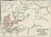
Nord- und Ostseeherrschaft II: Reich Waldemars II.
1 : 10000000 Ostseeraum Valdemar II., Danmark, Konge
[Ost-Europa in 6 Blättern, Blatt 3]
Handatlas über alle Theile der Erde und über das Weltgebäude Stieler, Adolf Justus Perthes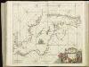
[125][128] Mare Balticum, uit: Atlas sive Descriptio terrarum orbis
Annotatie: Gedigitaliseerde versie. Amsterdam. Heiloo : Picturae (vervaardiger), 2015. tiff-bestand. Gedigitaliseerd: 07-01-2015; Origineel: Universiteitsbibliotheek Vrije Universiteit (XL.05127.-) ; Netherlands; Titelpagina ontbreekt Wit, Frederik de Amsterdam : Frederick de Wit
Pascaart Vande Oost-Zeeertoonende in sich, alle gelegentheden van Custen van Denemarcken, Sweden, Pomeren, Pruyssen, Courlant. Lyflant en Finlant [...] [Karte], in: Het vijfde Deel Des Grooten Atlas : Vervatende De Water-Weereld, S. 134.
1 Karte aus Atlas Jansson, Jan Jansson, Jan
Pascaart vande Oost-Zee [...] Tabula Hydrographica Baltici [...] [Karte], in: Novus atlas absolutissimus, Bd. 9, S. 179.
1 Karte aus Atlas Janssonius Offizin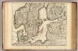
Courones du Nord (sud)
1 : 2600000 L'Isle, Guillaume de, 1675-1726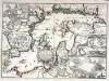
Accurate geographische Vorstellung der Ost-See
1 Karte : Kupferdruck ; 41 x 58 cm Riegel verlegt beÿ Christoph Riegel Buch- und Kunsthändlern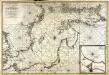
Nieuwe caart van de Oost Zee
1 Karte : Kupferdruck ; 58 x 85 cm chez Jean Cóvens et Corneille Mortier
Carte de la mer Baltique
1 Karte : Kupferdruck ; 60 x 88 cm Jaillot; Loon s.n.
Pas-caart van de Oost Zee
1 Karte : Kupferdruck ; 43 x 55 cm Doncker by Hendrick Doncker boekverkoper en graadbooghmaker inde Nieuwbrug-steegh in 't Stuurmans gereedtschap
Karta pochodov galernago flota 1712 - 1721 gg.
Ostsee Nordischer Krieg <1700-1721> Seeschlacht Galeere
K vojně so Švecīej 1808 - 1809 gg.
Schweden Seeschlacht Russisch-Schwedischer Krieg <1808-1809>
Kriegscarte zwischen Schweden und Rusland
nach den besten Carten gezeichnet von I.C. Iaeger Frankf. a/m : im Verlag der Jägerishen Landcarten Handlung