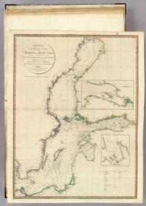
Maps of Sweden

Baltic Sea.
1 : 3400000 Faden, William, 1750?-1836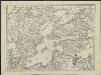
Kriegscarte zwischen Schweden und Rusland
nach den besten Carten gezeichnet von I.C. Iaeger Frankf. a/m : im Verlag der Jägerishen Landcarten Handlung
Die Ost See
1 : 500000 Baltské moře-oblast Flemming, Carl C. Flemming
Die Ost See
1 : 5000000 Baltské moře-oblast Flemming, Carl C. Flemming
Baltic Sea.
1 : 5000000 Philip, George
Ice Chart, Baltic Sea, February.
U.S. Navy
Charta öfver Sverige
1 : 6500000 utg. en 1789 af Fredr. Akrel förbättrad af Dan. Djurberg Stockholm : [s.n.]
Ice Chart, Baltic Sea, November.
U.S. Navy
Ice Chart, Baltic Sea, December.
U.S. Navy
Ice Chart, Baltic Sea, October.
U.S. Navy
Ice Chart, Baltic Sea, April.
U.S. Navy
Ice Chart, Baltic Sea, March.
U.S. Navy
Ice Chart, Baltic Sea, June.
U.S. Navy
Museumskart 46: Kart over Østersjøen
1 : 500000 Jens Sørensen
Ice Chart, Baltic Sea, May.
U.S. Navy
Karta pochodov galernago flota 1712 - 1721 gg.
Ostsee Nordischer Krieg <1700-1721> Seeschlacht Galeere
Ice Chart, Baltic Sea, January.
U.S. Navy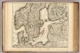
Courones du Nord (sud)
1 : 2600000 L'Isle, Guillaume de, 1675-1726
Svea ock Göta Riken med Finland ock Norland
1 : 1680000 Finsko Biurman, G.
(La Suede, la Finlande)
1 : 21000000 Bruyset, Jean-Marie; Schneider, J. H.
Pas-caart van de Oost Zee
1 Karte : Kupferdruck ; 43 x 55 cm Doncker by Hendrick Doncker boekverkoper en graadbooghmaker inde Nieuwbrug-steegh in 't Stuurmans gereedtschap
No.19. Karta Evropeyskaia Rossiia. Sheet 5
1 : 2000000 Shokalskago,Iu. M.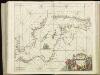
[125][128] Mare Balticum, uit: Atlas sive Descriptio terrarum orbis
Annotatie: Gedigitaliseerde versie. Amsterdam. Heiloo : Picturae (vervaardiger), 2015. tiff-bestand. Gedigitaliseerd: 07-01-2015; Origineel: Universiteitsbibliotheek Vrije Universiteit (XL.05127.-) ; Netherlands; Titelpagina ontbreekt Wit, Frederik de Amsterdam : Frederick de Wit
Pascaart vande Oost-Zee [...] Tabula Hydrographica Baltici [...] [Karte], in: Novus atlas absolutissimus, Bd. 9, S. 179.
1 Karte aus Atlas Janssonius Offizin
K vojně so Švecīej 1808 - 1809 gg.
Schweden Seeschlacht Russisch-Schwedischer Krieg <1808-1809>
Mare Balticum
1 Karte : Kupferdruck ; 49 x 57 cm Renard gedruckt by L. Renard
Pascaart Vande Oost-Zeeertoonende in sich, alle gelegentheden van Custen van Denemarcken, Sweden, Pomeren, Pruyssen, Courlant. Lyflant en Finlant [...] [Karte], in: Het vijfde Deel Des Grooten Atlas : Vervatende De Water-Weereld, S. 134.
1 Karte aus Atlas Jansson, Jan Jansson, Jan
Regni Sueciae in omnes suas subjacentes provincias accurate divisi tabula generalis
1 : 3200000 Finsko Homann, Johann Baptist â Ioh. Bapt. Homanno
REGNI SUECIAE in omnes suas Subjacentes Provincias accurate divisi Tabula Generalis
1 : 3200000 Finsko Homann, Johann Baptist a Ioh. Bapt. Homanno
Regni Sueciae in omnes suas subjacentes provincias accurate divisi tabula generalis
1 : 3200000 Skandinávie Homann, Johann Baptist â Ioh. Bapt. Homanno