Maps of Baltic Plains

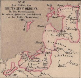
Das Gebiet des Deutschen Ordens in den Ostseeländern in seiner grössten Ausdehnung vor der Schl. v. Tannenberg 1410
Preußen (Ordensstaat)
Das Gebiet des Deutschen Ordens in den Ostseeländern in seiner grössten Ausdehnung vor der Schl. v. Tannenberg 1410
Preußen (Ordensstaat)
[Evropa]
Evropa
Mare Balticum
1 Karte : Kupferdruck ; 49 x 57 cm Renard gedruckt by L. Renard
Basin of the Baltic.
1 : 2400000 Johnston, Alexander Keith
Voenno-dorožnaja karta časti Rossii i pograničnych zemelʹ
1 : 1680000 Baltikum, Ostpreußen Šubert [Generalmajor]
K vojně so Švecīej 1808 - 1809 gg.
Schweden Seeschlacht Russisch-Schwedischer Krieg <1808-1809>
[125][128] Mare Balticum, uit: Atlas sive Descriptio terrarum orbis
Annotatie: Gedigitaliseerde versie. Amsterdam. Heiloo : Picturae (vervaardiger), 2015. tiff-bestand. Gedigitaliseerd: 07-01-2015; Origineel: Universiteitsbibliotheek Vrije Universiteit (XL.05127.-) ; Netherlands; Titelpagina ontbreekt Wit, Frederik de Amsterdam : Frederick de Wit
Pascaart vande Oost-Zee [...] Tabula Hydrographica Baltici [...] [Karte], in: Novus atlas absolutissimus, Bd. 9, S. 179.
1 Karte aus Atlas Janssonius Offizin
No.19. Karta Evropeyskaia Rossiia. Sheet 5
1 : 2000000 Shokalskago,Iu. M.
Pascaart Vande Oost-Zeeertoonende in sich, alle gelegentheden van Custen van Denemarcken, Sweden, Pomeren, Pruyssen, Courlant. Lyflant en Finlant [...] [Karte], in: Het vijfde Deel Des Grooten Atlas : Vervatende De Water-Weereld, S. 134.
1 Karte aus Atlas Jansson, Jan Jansson, Jan
Pas-caart van de Oost Zee
1 Karte : Kupferdruck ; 43 x 55 cm Doncker by Hendrick Doncker boekverkoper en graadbooghmaker inde Nieuwbrug-steegh in 't Stuurmans gereedtschap
Pas-Caart van de Oost Zee Verthonede Alle de gelegentheydt tusschen 't Eylandt Rugen ende Wyburg [Karte in 2 Teilen], in: De Nieuwe Groote Vermeerderde Zee-Atlas ofte Water-Werelt, S. 25.
1 Karte aus Atlas Doncker, Hendrick
Die Ostsee-Laender, Polen und Litthauen im Aufange des XIIIten. Jahrhunderts.
1 : 3800000 Spruner von Merz, Karl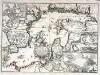
Accurate geographische Vorstellung der Ost-See
1 Karte : Kupferdruck ; 41 x 58 cm Riegel verlegt beÿ Christoph Riegel Buch- und Kunsthändlern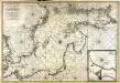
Nieuwe caart van de Oost Zee
1 Karte : Kupferdruck ; 58 x 85 cm chez Jean Cóvens et Corneille Mortier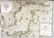
Carte de la mer Baltique
1 Karte : Kupferdruck ; 60 x 88 cm Jaillot; Loon s.n.
Poland.
1 : 3576320 Cummins Map Co.
Poland, Prussia.
1 : 4400000 Darton, William
Baltic States & East Prussia.
1 : 2000000 John Bartholomew and Son
Map of the several countries thro' which the Russians are to pass in their march to Prussia
1 : 5259000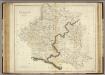
Poland.
1 : 2400000 Playfair, Principal
Partie, Russie. Europe 9.
1 : 1641836 Vandermaelen, Philippe, 1795-1869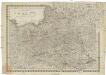
Königreich Pohlen sam[m]t den angränzenden Provinzen
1 : 2060000 Bělorusko Müller, Andreas bey Johann Schönberg
Kriegs Atlas 36 Karten von den Schauplätzen des Weltkrieges 1914/1915

Livoniae Nova Descriptio [Karte], in: Theatrum orbis terrarum, S. 375.
1 Karte aus Atlas Ortelius, Abraham Vrients, Jan Baptista
Livoniae Nova Descriptio [Karte], in: Theatrum orbis terrarum, S. 280.
1 Karte aus Atlas Ortelius, Abraham
Germany, eastern border regions : administrative divisions
1 : 2570000 Inset: Major administrative divisions. "July 1, 1944, information is shown within the 1937 Germany boundary only." "No. 6275." United States. Office of Strategic Services. Research and Analysis Branch. [Washington, D.C.] : R & A, OSS
Skizze zur Orientirung ϋber den Feldzug 1807