Maps of powiat płocki

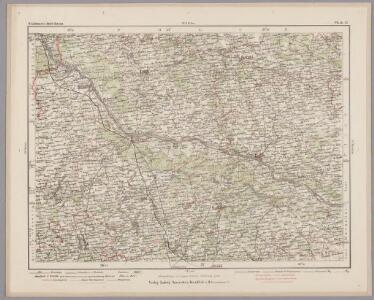
Plock 51, uit: Special-Karte von Mittel-Europa / nach amtlichen Quellen bearbeitet von W. Liebenow
1 : 300000 titelvariant: W. Liebenow's Mittel-Europa; Annotatie: Titel boven de bladen: W. Liebenow's Mittel-Europa Johannes Wilhelm Liebenow 1822-1897 Frankfurt a. M. : Ludwig Ravenstein
254. Argenau.
1 : 100000 Reichsamt fur Landesaufnahme
Composite: 279. Popowo.
1 : 100000 Reichsamt fur Landesaufnahme
Meßtischblatt 3377 : Radziejow, 1940
1 : 250000 Radziejow. - Aufn. 1932, hrsg. 1940. - 1:25000. - [Berlin]: Reichsamt für Landesaufnahme, 1940. - 1 Kt.
Meßtischblatt 3277 : Luisenfelde, 1936
1 : 250000 Luisenfelde. - Aufn. 1908, letzte Nachtr. 1929/34. - 1:25000. - [Berlin]: Reichsamt für Landesaufnahme, 1936. - 1 Kt.
Meßtischblatt 3177 : Neugrabia, 1936
1 : 250000 Neugrabia. - Aufn. 1891/1908,hrsg. 1909, letzte Nachtr. 1938. - 1:25000. - [Berlin]: Reichsamt für Landesaufnahme, 1936. - 1 Kt.
Meßtischblatt 3178 : Aleksandrów, 1936
1 : 250000 Aleksandrów. - Aufn. 1928, letzte Nachtr. 1930. - 1:25000. - [Berlin]: Reichsamt für Landesaufnahme, 1936. - 1 Kt.
Meßtischblatt 3077 : Podgorz (neu: Amberg), 1942
1 : 250000 Podgorz (neu: Amberg). - Ausg. m. dt. Namen, Ausg. 1940, [gedr. 19]42. - 1:25000. - [Berlin]: Reichsamt für Landesaufnahme, 1942. - 1 Kt.
Meßtischblatt 3078 : Schillno (neu: Drewenzwinkel), 1942
1 : 250000 Schillno (neu: Drewenzwinkel). - Ausg. m. dt. Namen, Ausg. 1940, [gedr. 19]42, vo. - 1:25000. - [Berlin]: Reichsamt für Landesaufnahme, 1942. - 1 Kt.
Composite: 254. Argenau.
1 : 100000 Reichsamt fur Landesaufnahme
Schema Teatra kampanīi 1806-7 gg.
Polen Napoleonische Kriege

Nr. 12. Die ersten Schlachten in Ostpreußen
Ostpreußen Weltkrieg <1914-1918>

Zweite Offensive in Polen
1 : 4000000 Polen Feldzug, Weltkrieg <1914-1918>
[Polen]
1 : 800000 Polsko S. Hirzel

Das Netz der polnischen Banken
Polen Provinz Posen Kreditwesen Banken

Die Preussische Provinz Posen, bestehend aus den Regierungs-Bezirken: Posen & Bromberg
1 : 1850000 Provinz Posen
Kolonie założone za panowania Fryderyka Wielkiego w Prusach Królewskich i w obwodzie nadnoteckim
Polen Ostpreußen Netzedistrikt Stadtgründung Friedrich II.
Sect. 16: Posen, uit: Geologische Karte des Deutschen Reichs in 27 Blaettern / [von] Richard Lepsius ; Red. von C. Vogel
1 : 500000 Annotatie: Blad 18 ontbreekt; Een aantal bladen op linnen; Een aantal bladen gereviseerd 1913-1914; Annotatie geografische gegevens: Met schaalstokken o.a. in kilometers; Legenda Carl Vogel 1828-1897 Gotha : Justus Perthes
Bez titulu: Přehledná mapa střední Evropy

Sect. 10: Bromberg, uit: Geologische Karte des Deutschen Reichs in 27 Blaettern / [von] Richard Lepsius ; Red. von C. Vogel
1 : 500000 Annotatie: Blad 18 ontbreekt; Een aantal bladen op linnen; Een aantal bladen gereviseerd 1913-1914; Annotatie geografische gegevens: Met schaalstokken o.a. in kilometers; Legenda Carl Vogel 1828-1897 Gotha : Justus Perthes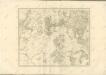

Sect. 11: Allenstein, uit: Geologische Karte des Deutschen Reichs in 27 Blaettern / [von] Richard Lepsius ; Red. von C. Vogel
1 : 500000 Annotatie: Blad 18 ontbreekt; Een aantal bladen op linnen; Een aantal bladen gereviseerd 1913-1914; Annotatie geografische gegevens: Met schaalstokken o.a. in kilometers; Legenda Carl Vogel 1828-1897 Gotha : Justus Perthes
Lódz 64, uit: Special-Karte von Mittel-Europa / nach amtlichen Quellen bearbeitet von W. Liebenow
1 : 300000 titelvariant: W. Liebenow's Mittel-Europa; Annotatie: Titel boven de bladen: W. Liebenow's Mittel-Europa Johannes Wilhelm Liebenow 1822-1897 Frankfurt a. M. : Ludwig Ravenstein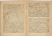
Kriegs Atlas 36 Karten von den Schauplätzen des Weltkrieges 1914/1915

Mapa fizyczna okolic Warszawy
1 : 400000 Varšava-oblast (Polsko) Inst. Wojsk. Geograficznego
Meßtischblatt 2977 : Thorn, 1942
1 : 250000 Thorn. - Ausg. m. dt. Namen, Ausg. 1940, [gedr. 19]42. - 1:25000. - [Berlin]: Reichsamt für Landesaufnahme, 1942. - 1 Kt. Mit vorläuf. Namensänd. (rot eingedr.)