Maps of Greater Poland Voivodeship

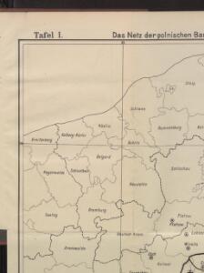
Das Netz der polnischen Banken
Polen Provinz Posen Kreditwesen Banken
Postarum seu Veredariorum Stationes Per Germaniam et Provincias Adiacentes.
1 : 400000 Mollova mapová sbírka Danckerts, Justus Danckerts, Cornelis
Carte Generale d'Allemagne
1 : 1300000 Mollova mapová sbírka Eisenschmidt, Johann Caspar Julien, Roch Joseph
Die Preussische Provinz Posen, bestehend aus den Regierungs-Bezirken: Posen & Bromberg
1 : 1850000 Provinz Posen
Marchionatus Brandenbvrgicvs
1 : 810000 Mollova mapová sbírka Blaeu, Joan Blaeu, Joan I.

Posen.
1 : 945000 Flemming, Carl
Kolonie założone za panowania Fryderyka Wielkiego w Prusach Królewskich i w obwodzie nadnoteckim
Polen Ostpreußen Netzedistrikt Stadtgründung Friedrich II.
Kreise der Provinz Posen 1864
Preußen, Provinz Posen, Verwaltungsgliederung Kunz, Andreas ; Moeschl, Joachim Robert
Danzig, Colberg, Thorn
1 : 750000 Gdaňsk (Polsko : oblast) Konrad, A. K. u. k. Militärgeographisches Institut
Danzig, Colberg, Thorn
1 : 750000 Gdaňsk (Polsko : oblast) K. k. militär-geographisches Institut
Provinz Posen
Grosser Hand-Atlas über alle Theile der Erde in 170 Karten Meyer, J. Verlag des Bibliographischen Instituts
Posen.
1 : 810000 Radefeld, Carl Christian Franz, 1788-1874
Die polnische Curve in Westpreußen
Polen Westpreußen Polen Bevölkerung
Provinz Posen
1 : 1200000 Provinz Posen

Languages in Prussian Poland
1 : 600000 First World War map of Languages in Prussian Poland. War Office
West Preussen.
1 : 940000 Flemming, Carl
Provinz Westpreussen
1 : 1250000 Westpreußen
Provinz Westpreussen
1 : 472000 Gdaňsk (Polsko) Handtke, Friedrich Carl Flemming
Bromberg
1 : 600000 Opitz, Carl Solbrig
Posen
1 : 600000 Opitz, Carl Solbrig
Belgicarum XVII Provinciarum Tabula
1 : 875000 Mollova mapová sbírka Danckerts, Justus Danckerts, Justus
Bez titulu: Přehledná mapa střední Evropy

Posen, Glogau, Schweidnitz, Oppeln, Kalisz
1 : 750000 Głogów (Polsko : oblast) Geng, K. K. u. k. Militärgeographisches Institut
Posen, Glogau, Schweidnitz, Oppeln, Kalisz
1 : 750000 Głogów (Polsko : oblast) K. k. militär-geographisches Institut
Palatinatus Posnaniensis. In Majori Polonia Primarii Nova Delinatio [Karte], in: Novus atlas absolutissimus, Bd. 1, S. 96.
1 Karte aus Atlas Janssonius Offizin
Übersichtskarte von Mittel - Europa

Monumenta Cartographica Bohemiae II.: Müllerova mapa