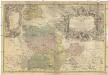
Maps of Greater Poland Voivodeship

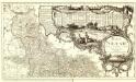
Palatinatus Posnaniensis. In Majori Polonia Primarii Nova Delinatio [Karte], in: Novus atlas absolutissimus, Bd. 1, S. 96.
1 Karte aus Atlas Janssonius Offizin
PALATINATVS | POSNANIENSIS, | IN MAIORI POLONIA PRIMARII
NOVA DELINEATIO | Per G.F.M. Gerard Coeck sculpsit. Amsterdami | Exc. Joannes Blaeu.
Belgicarum XVII Provinciarum Tabula
1 : 875000 Mollova mapová sbírka Danckerts, Justus Danckerts, Justus
Posen.
1 : 810000 Radefeld, Carl Christian Franz, 1788-1874
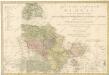
Provinz Posen
1 : 1200000 Provinz Posen
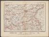
Kreise der Provinz Posen 1864
Preußen, Provinz Posen, Verwaltungsgliederung Kunz, Andreas ; Moeschl, Joachim Robert
Posen.
1 : 945000 Flemming, Carl
Provinz Posen
Grosser Hand-Atlas über alle Theile der Erde in 170 Karten Meyer, J. Verlag des Bibliographischen Instituts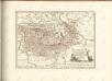
Posen
1 : 600000 Opitz, Carl Solbrig
Silesia Inferior. [Karte], in: Theatrum orbis terrarum, sive, Atlas novus, Bd. 1, S. 144.
1 Karte aus Atlas Blaeu, Joan Blaeu, Willem Janszoon
Silesia Inferior. [Karte], in: Le théâtre du monde, ou, Nouvel atlas contenant les chartes et descriptions de tous les païs de la terre, Bd. 1, S. 210.
1 Karte aus Atlas Blaeu, Willem Janszoon und Blaeu, Joan Blaeu, Willem Janszoon
Silesia Inferior [Karte], in: Novus atlas absolutissimus, Bd. 2, S. 255.
1 Karte aus Atlas Janssonius Offizin
Silesia Inferior. [Karte], in: Novus Atlas, das ist, Weltbeschreibung, Bd. 1, S. 179.
1 Karte aus Atlas Blaeu, Joan Blaeu, Willem Janszoon
SILESIA | INFERIOR
Noviter et accurata delineata | á Jona Sculteto Sprotta Silesio. [Amsterdam : Joan Blaeu]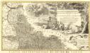
Novissimum Silesiae Theatrum
1 : 400800 Mollova mapová sbírka Condet, Johannes Covens, Johannes I
Monumenta Cartographica Bohemiae II.: Müllerova mapa

Basse Silesie Raduitte en deux Feuilles sur celle de 16 Faittes sur les lieux
1 : 408000 Mollova mapová sbírka Le Rouge, Georges-Louis Schubarth, Matthäus
Sect. 15: Frankfurt a/O, uit: Geologische Karte des Deutschen Reichs in 27 Blaettern / [von] Richard Lepsius ; Red. von C. Vogel
1 : 500000 Annotatie: Blad 18 ontbreekt; Een aantal bladen op linnen; Een aantal bladen gereviseerd 1913-1914; Annotatie geografische gegevens: Met schaalstokken o.a. in kilometers; Legenda Carl Vogel 1828-1897 Gotha : Justus Perthes
Ducatus Silesiae Glogani Ver Delineatio [Karte], in: Le théâtre du monde, ou, Nouvel atlas contenant les chartes et descriptions de tous les païs de la terre, Bd. 1, S. 213.
1 Karte aus Atlas Blaeu, Willem Janszoon und Blaeu, Joan Blaeu, Willem Janszoon
Ducatus Silesiae Glogani Vera Delineatio [Karte], in: Novus atlas absolutissimus, Bd. 2, S. 258.
1 Karte aus Atlas Janssonius Offizin
Silesia Inferior
1 : 870000 Mollova mapová sbírka Scultetus, Johannes Schenk, Peter I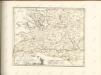
Das Fürstenthum Glogau in seine sechs landrathlichen Kreise
PRINCIPATVS SILESIAE GLOGOVIENSIS novissima Tabula Geographica
1 : 203000 Głogów (Polsko) Wieland, Johann Wolfgang Schubarth, Matthaeus ab Haeredibus Homannianis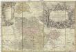
Principatvs Silesiae Glogoviensis novissima tabula geographica sistens 6 ejusdem circulos Glogav, Freystadt, Gvhrav, Sprottav, Grünberg et Schwiebvs, cum districtu Polckwitz nec non liberam dynastiam Bevthen et Carolath
1 : 208000 Głogów (Polsko) Wieland, Johann Wolfgang Schubarth, Matthäus Homannianos Heredes
Principatvs Silesiae Glogoviensis novissima tabula geographica sistens VI. ejusdem circulos Glogav, Freystadt, Gvhrav, Sprottav, Grvnberg et Schwiebvs, cum districtu Polckwitz nec non liberam dynastiam Bevthen et Carolath
1 : 200000 Głogów (Polsko) Wieland, Johann Wolfgang Schubarth, Matthäus ab Haeredibus Homannianis
![Palatinatus Posnaniensis. In Majori Polonia Primarii Nova Delinatio [Karte], in: Novus atlas absolutissimus, Bd. 1, S. 96.](https://images-2.georeferencer.com/images/iiif/541850407748/full/,300/0/native.jpg)

