Maps of Pomeranian Voivodeship

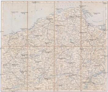
Danzig, Colberg, Thorn
1 : 750000 Gdaňsk (Polsko : oblast) Konrad, A. K. u. k. Militärgeographisches Institut
Danzig, Colberg, Thorn
1 : 750000 Gdaňsk (Polsko : oblast) K. k. militär-geographisches Institut

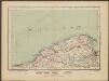
West Preussen.
1 : 940000 Flemming, Carl
Provinz Westpreussen
1 : 472000 Gdaňsk (Polsko) Handtke, Friedrich Carl Flemming
Kolonie założone za panowania Fryderyka Wielkiego w Prusach Królewskich i w obwodzie nadnoteckim
Polen Ostpreußen Netzedistrikt Stadtgründung Friedrich II.
Die polnische Curve in Westpreußen
Polen Westpreußen Polen Bevölkerung
Languages in Prussian Poland
1 : 600000 First World War map of Languages in Prussian Poland. War Office
Provinz Westpreussen
1 : 1250000 Westpreußen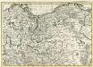
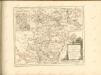
Mappa Geographica summo labore, accurate et novissime exarata, exhibens Circulos aliquot Germaniae, praesertim illos ubi Bellum nunc Geritur
1 : 1300000 Mollova mapová sbírka Lotter, Tobias Conrad Lotter, Tobias Conrad
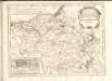
Bromberg
1 : 600000 Opitz, Carl Solbrig

Sect. 10: Bromberg, uit: Geologische Karte des Deutschen Reichs in 27 Blaettern / [von] Richard Lepsius ; Red. von C. Vogel
1 : 500000 Annotatie: Blad 18 ontbreekt; Een aantal bladen op linnen; Een aantal bladen gereviseerd 1913-1914; Annotatie geografische gegevens: Met schaalstokken o.a. in kilometers; Legenda Carl Vogel 1828-1897 Gotha : Justus Perthes
Svobodné město Gdansk (Danzig)
1 : 300000 Gdaňsk-oblast (Polsko) Jordán, V. O. Girgal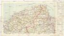
Mapa samochodowa Rzeczypospolitej Polskiej
1 : 300000 Gdaňsk-oblast (Polsko) wydanie Wojskowego instytutu geograficznego
Danzig
1 : 600000 Opitz, Carl Solbrig
Sect. 9: Stettin, uit: Geologische Karte des Deutschen Reichs in 27 Blaettern / [von] Richard Lepsius ; Red. von C. Vogel
1 : 500000 Annotatie: Blad 18 ontbreekt; Een aantal bladen op linnen; Een aantal bladen gereviseerd 1913-1914; Annotatie geografische gegevens: Met schaalstokken o.a. in kilometers; Legenda Carl Vogel 1828-1897 Gotha : Justus Perthes
Tempelburg 37, uit: Special-Karte von Mittel-Europa / nach amtlichen Quellen bearbeitet von W. Liebenow
1 : 300000 titelvariant: W. Liebenow's Mittel-Europa; Annotatie: Titel boven de bladen: W. Liebenow's Mittel-Europa Johannes Wilhelm Liebenow 1822-1897 Frankfurt a. M. : Ludwig Ravenstein
Danzig 26, uit: Special-Karte von Mittel-Europa / nach amtlichen Quellen bearbeitet von W. Liebenow
1 : 300000 titelvariant: W. Liebenow's Mittel-Europa; Annotatie: Titel boven de bladen: W. Liebenow's Mittel-Europa Johannes Wilhelm Liebenow 1822-1897 Frankfurt a. M. : Ludwig Ravenstein
Bromberg 38, uit: Special-Karte von Mittel-Europa / nach amtlichen Quellen bearbeitet von W. Liebenow
1 : 300000 titelvariant: W. Liebenow's Mittel-Europa; Annotatie: Titel boven de bladen: W. Liebenow's Mittel-Europa Johannes Wilhelm Liebenow 1822-1897 Frankfurt a. M. : Ludwig Ravenstein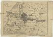
Die Stadt Dantzig mit ihren Gebiet und einigen umliegenden Gegenden nach den neuesten Karten
1 : 95000 Gdaňsk-oblast (Polsko)
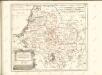

Der Arenswaldische Creis
1 : 290000 Sotzmann, Daniel Friedrich
Gdańsk
Polen Danzig Gdansk Grenze Wierzbicki, B.
Karte von Danzig, Elbing, und Marienburg oder erstes Blat von Westpreussen
1 : 137000 Elbląg (Polsko) Endersch, Johann Friedrich Amon, Anton F.A. Schraembl
Karte von Danzig, Elbing, und Marienburg oder erstes Blat von Westpreussen
1 : 137000 Elbląg (Polsko) Endersch, Johann Friedrich Amon, Anton F.A. Schraembl
Karte von Danzig, Elbing, und Marienburg oder erstes Blat von Westpreussen
1 : 137000 Elbląg (Polsko) Endersch, Johann Friedrich Amon, Anton F.A. Schraembl