Maps of Masovian Voivodeship


Topographische Karte der Gegend um Warschau
Varšava-oblast (Polsko) Artaria

West-Galizien
Chełm-oblast (Polsko) Müller, Karl Benedict, Ant. im Verlage des Kunst und Industrie Comptoirs
Warszawa, Brest-Litowsk, Radom, Lublin, Kielze, Tomaszów

Sect. 16: Posen, uit: Geologische Karte des Deutschen Reichs in 27 Blaettern / [von] Richard Lepsius ; Red. von C. Vogel
1 : 500000 Annotatie: Blad 18 ontbreekt; Een aantal bladen op linnen; Een aantal bladen gereviseerd 1913-1914; Annotatie geografische gegevens: Met schaalstokken o.a. in kilometers; Legenda Carl Vogel 1828-1897 Gotha : Justus Perthes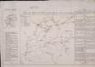
Feldzug der Russen und Polen zwischen Bug und Narew vom 13ten bis 26sten Mai 1831

Mapa fizyczna okolic Warszawy
1 : 400000 Varšava-oblast (Polsko) Inst. Wojsk. Geograficznego
Warszawa

Brzesc nad Bugiem

Die Einnahme von Brest-Litowsk. (26. August 1915.)
Brest-Litowsk Weltkrieg <1914-1918>, Eroberung
Kriegs Atlas 36 Karten von den Schauplätzen des Weltkrieges 1914/1915

Siedlee 53, uit: Special-Karte von Mittel-Europa / nach amtlichen Quellen bearbeitet von W. Liebenow
1 : 300000 titelvariant: W. Liebenow's Mittel-Europa; Annotatie: Titel boven de bladen: W. Liebenow's Mittel-Europa Johannes Wilhelm Liebenow 1822-1897 Frankfurt a. M. : Ludwig Ravenstein
Lódz 64, uit: Special-Karte von Mittel-Europa / nach amtlichen Quellen bearbeitet von W. Liebenow
1 : 300000 titelvariant: W. Liebenow's Mittel-Europa; Annotatie: Titel boven de bladen: W. Liebenow's Mittel-Europa Johannes Wilhelm Liebenow 1822-1897 Frankfurt a. M. : Ludwig Ravenstein
Kalisch 63, uit: Special-Karte von Mittel-Europa / nach amtlichen Quellen bearbeitet von W. Liebenow
1 : 300000 titelvariant: W. Liebenow's Mittel-Europa; Annotatie: Titel boven de bladen: W. Liebenow's Mittel-Europa Johannes Wilhelm Liebenow 1822-1897 Frankfurt a. M. : Ludwig Ravenstein
Plock 51, uit: Special-Karte von Mittel-Europa / nach amtlichen Quellen bearbeitet von W. Liebenow
1 : 300000 titelvariant: W. Liebenow's Mittel-Europa; Annotatie: Titel boven de bladen: W. Liebenow's Mittel-Europa Johannes Wilhelm Liebenow 1822-1897 Frankfurt a. M. : Ludwig Ravenstein
Bialystok 41, uit: Special-Karte von Mittel-Europa / nach amtlichen Quellen bearbeitet von W. Liebenow
1 : 300000 titelvariant: W. Liebenow's Mittel-Europa; Annotatie: Titel boven de bladen: W. Liebenow's Mittel-Europa Johannes Wilhelm Liebenow 1822-1897 Frankfurt a. M. : Ludwig Ravenstein
[Tykotzin, Białystok, Zabłudowo, Mazowieck, Bielsk, Narew, Ciechanowiec, Bócki, Orla]
1 : 100000 Białystok-oblast (Polsko)
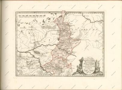
West Galizien
Chełm-oblast (Polsko) Müller, Karl Benedict, Ant. Kunst und Industrie Comptoirs
West Galizien
Halič (Polsko a Ukrajina) Müller, Karl Benedict, Ant. im Verlage des Kunst und Industrie Comptoirs
Composite: 301. Posen.
1 : 100000 Reichsamt fur Landesaufnahme
Warschau 52, uit: Special-Karte von Mittel-Europa / nach amtlichen Quellen bearbeitet von W. Liebenow
1 : 300000 titelvariant: W. Liebenow's Mittel-Europa; Annotatie: Titel boven de bladen: W. Liebenow's Mittel-Europa Johannes Wilhelm Liebenow 1822-1897 Frankfurt a. M. : Ludwig Ravenstein
Neidenburg 40, uit: Special-Karte von Mittel-Europa / nach amtlichen Quellen bearbeitet von W. Liebenow
1 : 300000 titelvariant: W. Liebenow's Mittel-Europa; Annotatie: Titel boven de bladen: W. Liebenow's Mittel-Europa Johannes Wilhelm Liebenow 1822-1897 Frankfurt a. M. : Ludwig Ravenstein
Obwod Białostocki
Białystok-oblast (Polsko)
301. Posen.
1 : 100000 Reichsamt fur Landesaufnahme
Radom 65, uit: Special-Karte von Mittel-Europa / nach amtlichen Quellen bearbeitet von W. Liebenow
1 : 300000 titelvariant: W. Liebenow's Mittel-Europa; Annotatie: Titel boven de bladen: W. Liebenow's Mittel-Europa Johannes Wilhelm Liebenow 1822-1897 Frankfurt a. M. : Ludwig Ravenstein
Sect. 11: Allenstein, uit: Geologische Karte des Deutschen Reichs in 27 Blaettern / [von] Richard Lepsius ; Red. von C. Vogel
1 : 500000 Annotatie: Blad 18 ontbreekt; Een aantal bladen op linnen; Een aantal bladen gereviseerd 1913-1914; Annotatie geografische gegevens: Met schaalstokken o.a. in kilometers; Legenda Carl Vogel 1828-1897 Gotha : Justus Perthes