Maps of Masovian

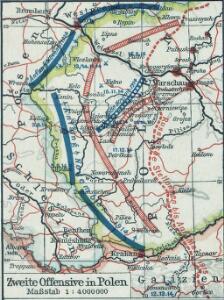
Zweite Offensive in Polen
1 : 4000000 Polen Feldzug, Weltkrieg <1914-1918>
Erste Offensive in Polen
1 : 4000000 Polen Feldzug, Weltkrieg <1914-1918>
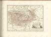
Neueste Karte von Galizien und Lodomerien nebs dem oesterreichischen neuen Antheil von Polen
1 : 1110000 Halič (Polsko a Ukrajina) Müller, Franz Artaria und Compagnie
[Polen]
1 : 800000 Polsko S. Hirzel
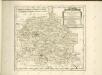
Ducatus Silesiae Tabula
1 : 2800000 1 Karte : Kupferdruck ; 13 x 17 cm Weigel, Johann Christoph [Johann Christoph Weigel]

Mappa geographica exactissima continens Imperatoris Hæreditarium Dominium Silesiam, nec non eiusdem Provincias interiores Ducatus, Comitatus, Baronatus etc.
1 : 700000 edente Petro Schenck [Amsterdam] : edente Petro Schenck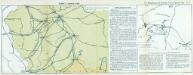
Nr. 13. Einfälle in Russisch-Polen
Polen Weltkrieg <1914-1918>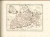

Strategische Übersichts-Karte des polnisch-litaurischen Armee-Bewegungraumes
Galizien, Karpathen, Bukowina nebst anschließendem Ungarn, Russland u. s. w.
Ravenstein, Hans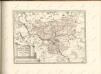

Strassen- und Eisenbahnkarte des oesterreichischen Kaiserthumes
1 : 864000 Blatt 3 Schaller, G. K.K. Militärisch-Geografisches Institut, Karten-Evidenthaltungs-Abteilung
Kolonie założone za panowania Fryderyka Wielkiego na Śląsku pruskim
Polen Schlesien Preußen Stadtgründung Friedrich II.
Charte von Schlesien und Maehren
Morava (Česko) Kipferling, Karl Joseph Riedl, J. in J. Riedl's Kunsthandlung
Post und Eisenbahnkarte der Österreichisch-Ungarischen Monarchie

Ungarn. Comitate: Sohler, Trentschin, Thurocz, Arva, Liptau, Zips, Járos, Zemplin. Gallicien Kreise: Wadowicz, Bochnia, Szandecz, Jaszlo, Tarnow
Ungarn Verkehrsweg
Bez titulu: Přehledná mapa střední Evropy
Nr. 13. Der Durchbruch bei Tarnow-Gorlice. (2. Mai 1915.)
Gorlice (Region) Gorlice / Schlacht, Weltkrieg <1914-1918>

Kartographische Darstellung der Abstimmungs-Ergebnisse von Oberschlesien
1 : 100000 [im Auftrag des Auswärtigen Amtes bearb. in der Plankammer des Preußisch-Statistischen Landesamtes vom Gerke] ; mit Genehmigung der Landesaufnahme, Berlin Berlin : Berliner Lithographisches Institut
West Galizien
Bochnia (Polsko) Müller, Karl Metzburg, Georg Ignaz von im Verlage des Kunst und Industrie Comptoirs
West Galizien
Halič (Polsko a Ukrajina) Müller, Karl Metzburg, Georg Ignaz von im Verlage des Kunst und Industrie Comptoirs
Sect. 16: Posen, uit: Geologische Karte des Deutschen Reichs in 27 Blaettern / [von] Richard Lepsius ; Red. von C. Vogel
1 : 500000 Annotatie: Blad 18 ontbreekt; Een aantal bladen op linnen; Een aantal bladen gereviseerd 1913-1914; Annotatie geografische gegevens: Met schaalstokken o.a. in kilometers; Legenda Carl Vogel 1828-1897 Gotha : Justus Perthes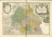

Granica Polski na Śląsku górnym
1 : 600000 Polsko Instytut kartograficzny Atlas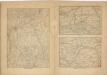
Kriegs Atlas 36 Karten von den Schauplätzen des Weltkrieges 1914/1915