Maps of Tatra Mountains

Ungarn. Comitate: Sohler, Trentschin, Thurocz, Arva, Liptau, Zips, Járos, Zemplin. Gallicien Kreise: Wadowicz, Bochnia, Szandecz, Jaszlo, Tarnow
Ungarn Verkehrsweg
Blatt III, uit: Geologische Übersichts-Karte der Österreichisch-Ungarischen Monarchie / nach den Aufnahmen der K.K. Geologischen Reichsanstalt bearb. von Franz Ritter von Hauer ; gezeichn. von Eduard Jahn
1 : 576000 Annotatie geografische gegevens: Gebaseerd op veldwerk in de jaren 1850 tot 1865 Hauer, Franz Ritter von; Jahn, Eduard; Kaiserlich-Königliche Geologische Reichsanstalt, Wenen Wien : Beck
Strassen- und Eisenbahnkarte des oesterreichischen Kaiserthumes
1 : 864000 Blatt 3 Schaller, G. K.K. Militärisch-Geografisches Institut, Karten-Evidenthaltungs-Abteilung
Übrige Länder der ehemaligen Österreich-Ung. Monarchie
1 : 900000 Halič (Polsko a Ukrajina) Koch, Wilhelm Opitz, Carl Arnd
Post und Eisenbahnkarte der Österreichisch-Ungarischen Monarchie
Nr. 13. Der Durchbruch bei Tarnow-Gorlice. (2. Mai 1915.)
Gorlice (Region) Gorlice / Schlacht, Weltkrieg <1914-1918>
Strategische Übersichts-Karte des polnisch-litaurischen Armee-Bewegungraumes

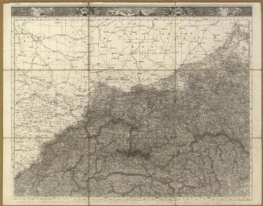
Sheet IV: Karte Des Oesterreichischen Kaiserstaates.
1 : 576000 Scheda, Josef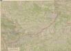
Galizien, Karpathen, Bukowina nebst anschließendem Ungarn, Russland u. s. w.
Ravenstein, Hans
IV, uit: General-Karte des oesterreichischen Kaiserstaates mit einem grossen Theile der angrenzenden Länder / durch Josef Scheda ... bearb. und hrsg
1 : 576000 Annotatie geografische gegevens: Maatstokken: oesterreichische Meilen, geografische oder deutsche Meilen, preussische Meilen, türkische Berri, französische Lieues, russische Werste; Maatstok per blad: wiener Klafter, öster. Meilen; Blad XIX: statistische en taalkundige informatie; Blad XIX: legenda [Wien : K.K. Militärisch-Geografisches Institut]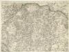
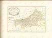
Augustissimo Romanor. Imperatori Iosepho I. Hungaria Regi Invictissimo Mappam Hanc Regni Hungariae
1 : 540000 Mollova mapová sbírka Müller, Johann Christoph
Übersichtskarte von Mittel - Europa

West Galizien
Bochnia (Polsko) Müller, Karl Metzburg, Georg Ignaz von im Verlage des Kunst und Industrie Comptoirs
West Galizien
Halič (Polsko a Ukrajina) Müller, Karl Metzburg, Georg Ignaz von im Verlage des Kunst und Industrie Comptoirs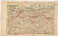
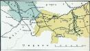
Strecke
Krakov (Polsko) K. k. Österreichische Staatsbahnen
Übersichtskarte von Mittel - Europa

Die im Stadtbuch von Zipser Neudorf genannten Orte
Zips, Spišská Nová Ves, Stadtbuch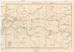
Galizien, Westlicher Theil
1 : 700000 Halič (Polsko a Ukrajina) Karl Fr. Pfau
Carte de la Roumanie et pays limitrophes. Cracovie
1 : 500000 France. Service géographique de l'armée [Paris] : Service géographique de l'armée
Novissima et accuratissima XVII Provinciarum Germaniae Inferioris Tabula
1 : 1500000 Mollova mapová sbírka Wit, Frederik de Deur, Abraham Janszoon Ottens, Josua
Novissima et accuratissima XVII Provinciarum Germaniae Inferioris Delineatio
1 : 1050000 Mollova mapová sbírka Schagen, Gerhardus Schagen, Gerhardus
Novissima et accuratissima XVII Provinciarum Germaniae Inferioris Delineatio
1 : 1500000 Mollova mapová sbírka Visscher, Nicolaes Deur, Abraham Janszoon Visscher, Nicolaus I.
Germaniae Inferioris XVII Provinciarum Accuratissima Tabula
1 : 1500000 Mollova mapová sbírka Visscher, Nicolaes Jansz. Deur, Abraham Janszoon Visscher, Nicolaus II.
Krakau, Przemysl, Jaroslau, Kaschau, Leutschau
1 : 750000 Krakov (Polsko : oblast) Geng, K. K. u. k. Militärgeographisches Institut
Krakau, Przemysl, Jaroslau, Kaschau, Leutschau
1 : 750000 Krakov (Polsko : oblast) Geng, K. K. u. k. Militärgeographisches Institut
Krakau, Przemyśl, Jaroslau, Kaschau, Leutschau
1 : 750000 Jarosław (Polsko) R. Lechner
Krakau, Przemyśl, Jaroslau, Kaschau, Leutschau
1 : 750000 Jarosław (Polsko) K. k. militär-geographisches Institut
Volební mapa do říšského sněmu
1 : 1000000 Morava (Česko) G. Freytag & Berndt