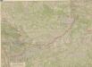
Maps of Slovakia

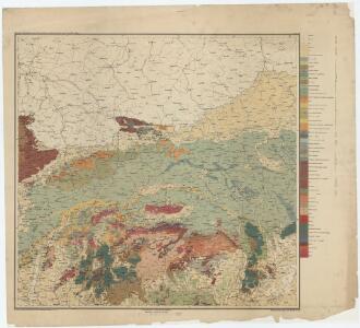
Blatt III, uit: Geologische Übersichts-Karte der Österreichisch-Ungarischen Monarchie / nach den Aufnahmen der K.K. Geologischen Reichsanstalt bearb. von Franz Ritter von Hauer ; gezeichn. von Eduard Jahn
1 : 576000 Annotatie geografische gegevens: Gebaseerd op veldwerk in de jaren 1850 tot 1865 Hauer, Franz Ritter von; Jahn, Eduard; Kaiserlich-Königliche Geologische Reichsanstalt, Wenen Wien : Beck
Übrige Länder der ehemaligen Österreich-Ung. Monarchie
1 : 900000 Halič (Polsko a Ukrajina) Koch, Wilhelm Opitz, Carl Arnd
Geologická mapa Československé republiky

Československá socialistická republika
Neueste Karte von Galizien und Lodomerien nebs dem oesterreichischen neuen Antheil von Polen
1 : 1110000 Halič (Polsko a Ukrajina) Müller, Franz Artaria und Compagnie
Strassen- und Eisenbahnkarte des oesterreichischen Kaiserthumes
1 : 864000 Blatt 3 Schaller, G. K.K. Militärisch-Geografisches Institut, Karten-Evidenthaltungs-Abteilung
Ungarn. Comitate: Sohler, Trentschin, Thurocz, Arva, Liptau, Zips, Járos, Zemplin. Gallicien Kreise: Wadowicz, Bochnia, Szandecz, Jaszlo, Tarnow
Ungarn Verkehrsweg
Internationale Weltkarte 1:1000 000
1 : 1000000 Krakov-oblast (Polsko) Generalstab des Heeres, Abteilung für Kriegskarten und Vermessungswesen
Post und Eisenbahnkarte der Österreichisch-Ungarischen Monarchie

Republika Československá

Oesterreichisch-Ungarische Monarchie

Strategische Übersichts-Karte des polnisch-litaurischen Armee-Bewegungraumes

Národnostní mapa Republiky československé
Boháč, Antonín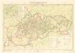
Slovenské národné povstanie

Sheet IV: Karte Des Oesterreichischen Kaiserstaates.
1 : 576000 Scheda, Josef
Nástěnná mapa Československé republiky
Machát, František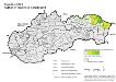
Slowakei 2001. Ruthenen (rusínska národnost’)
Slowakei ethnische Gruppe, Russinen Hofinger, Veronika
Wandkarte der Čechoslovakischen republik
Machát, František
scholl- („sollen“-Anlaut)
Slowakei Linguistik, Deutsch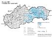
Slowakei 2001. Roma (rómska národnost’)
Slowakei ethnische Gruppe, Roma
mhd. -f > -p, -b
Slowakei Lautverschiebung, Mittelhochdeutsch
baußen, binnen, boben, binnen
Slowakei Lautverschiebung, Deutsch
-bas -bis
Slowakei Lautverschiebung, Mittelhochdeutsch
mhd. o > a
Slowakei Lautverschiebung, Mittelhochdeutsch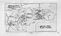
Gotische Städte in der Slowakei
Slowakei Stadt, Gotik
mhd. ph- > tph-
Slowakei Lautverschiebung, Mittelhochdeutsch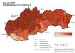
Slowakei 2001. Slowaken (slovenská národnost’)
Slowakei ethnische Gruppe, Slowaken Hofinger, Veronika
Der ostdeutsche Kolonialtyp
Slowakei Städtebau