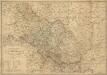
Maps of County Lodzki

Lódz 64, uit: Special-Karte von Mittel-Europa / nach amtlichen Quellen bearbeitet von W. Liebenow
1 : 300000 titelvariant: W. Liebenow's Mittel-Europa; Annotatie: Titel boven de bladen: W. Liebenow's Mittel-Europa Johannes Wilhelm Liebenow 1822-1897 Frankfurt a. M. : Ludwig Ravenstein
Der Durchbruch bei Brzeziny 21. bis 23. November 1914
Brzeziny Schlacht
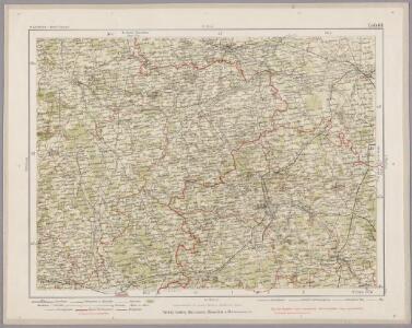
Lodz
1 : 75000 Lodž-oblast (Polsko) K. u. k. Militärgeographisches Institut
Lask
1 : 75000 K. u. k. Militärgeographisches Institut
Pabianice
1 : 75000 K. u. k. Militärgeographisches Institut
Ozorków
1 : 75000 K. u. k. Militärgeographisches Institut
Tomaszów
1 : 75000 Polsko Karbiutz, F. K. u. k. Militärgeographisches Institut
Skierniewice
1 : 75000 Skierniewice (Polsko) Bayer, R. K. u. k. Militärgeographisches Institut
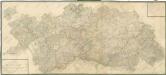
Plan des environs de Kalisz
1 : 42000 Kalisz-oblast (Polsko)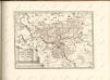

Silesia ducatus nova descriptio
1 : 950000 Slezsko Keere, Pieter van den Petro Kaerio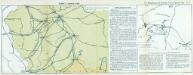
Nr. 13. Einfälle in Russisch-Polen
Polen Weltkrieg <1914-1918>
Theatre de la guerre en Silesie
1 : 780000 Slezsko (Polsko) Le Rouge, Georges-Louis Raffelsperger, Franz Le Rouge

Zweite Offensive in Polen
1 : 4000000 Polen Feldzug, Weltkrieg <1914-1918>
Accurate Vorstellung des Herzogthums Schlesien
Mollova mapová sbírka
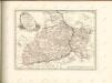
Schlesien in nieder- und ober Schlesien, dann in Fürstenthümer eingetheilt, nebst der Grafschaft Glatz
1 : 1057000 Kladsko-oblast (Polsko) Mollo, Tranquillo T. Mollo
Schlesien in Nieder- und Ober Schlesien, dann in Fürstenthümer eingetheilt, nebst der Grafschaft Glatz
1 : 1057000 Kladsko-oblast (Polsko) Mollo, Tranquillo T. Mollo
Charte von Schlesien und Maehren, Zum Gebrauche der Oesterreichischen Schulen entworfen
1 : 1100000 Mollova mapová sbírka Kipferling, Karl Joseph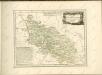
Mappa Geographica Ducatus Sylesiae

[Polen]
1 : 800000 Polsko S. Hirzel
Ducatus Silesiae Tabula
1 : 2800000 1 Karte : Kupferdruck ; 13 x 17 cm Weigel, Johann Christoph [Johann Christoph Weigel]
Mappa geographica exactissima continens Imperatoris Hæreditarium Dominium Silesiam, nec non eiusdem Provincias interiores Ducatus, Comitatus, Baronatus etc.
1 : 700000 edente Petro Schenck [Amsterdam] : edente Petro Schenck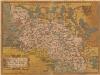
Silesiae Typus [Karte], in: Theatrum orbis terrarum, S. 65.
1 Karte aus Atlas Ortelius, Abraham
Karte von Schlesien
1 : 584000 Morava (Česko) Picquet, Ch. Picquet
Karte von Schlesien
1 : 584000 Morava (Česko) Picquet, Ch. Picquet