Maps of Jan Mayen

Feuille 3 (C I), uit: Carte géologique internationale de l'Europe : la carte, votée au congrès géologique international de Bologne en 1881, est exécutée conformément aux décisions d'une commission internationale, avec le concours des gouvernements, sous le dir. de M.M. Beyrich et Hauchecorne
Annotatie: Blad 48 gamme des couleurs; blad 49: bladwijzer en titelblad Heinrich Ernst Beyrich 1815-1896; Wi. Hauchecorne Berlin : Reimer / (Berlin: Institut lithographique)
Insulae Iohannis Mayen Cum universo situ Sinuum et Promontoriorum. [...] [Karte], in: Het vijfde Deel Des Grooten Atlas : Vervatende De Water-Weereld, S. 131.
1 Karte aus Atlas Jansson, Jan Jansson, Jan
INSVLA | QVÆ À | IOANNE MAYEN | NOMEN SORTITA EST.
[Amsterdam : Joan Blaeu]
Insulae Iohannis Mayen Cum universo situ Sinuum et Promontoriorum. Nova descriptio. [Karte], in: Novus atlas absolutissimus, Bd. 9, S. 176.
1 Karte aus Atlas Janssonius Offizin
Spesielle kart 132: Jan Mayen nach der Aufnahme der Österreich arct
1 : 100000
Spesielle kart 64: Norvège Carte Zoo-Géographique, blad 1
1 : 2400000 Robert Collett
Spesielle kart 65-3: Oversigtskart over de paa den norske Kyst anbragte Fyre
1 : 1000000
Spesielle kart 18 Nord-vest: Telegrafkart over Norge
1 : 1000000 Den Private Opmaaling, Kristiania
Scotland.
1 : 1530000 Greenleaf, Jeremiah
Scotland.
1 : 1457280 Greenleaf, Jeremiah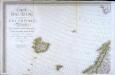
Carte d'Europe ou sont tracées les limites des empires, royaumes, et etats souverains, feuille 1
1 Blatt : 63 x 96 cm Semen etc
Museumskart 178: Sjøkart over Norskehavet
1 : 1000000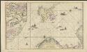
Nieuwe pascaart inhoudende 't noorder deel van Europa sijnde seer dienstigh voor de Groenlandse en Moskovise scheepvaart
1 : 3500000 nieuwelijkx opgestelt door G. v. Keulen t'Amsterdam : bij Johannes van Keulen, Zeekaard Verkooper en Graad-boog maker Aande Oost Zijde vande Nieuwen Brugh Inde Gekroonde Lootsman
Russian Empire.
1 : 21000000 Greenleaf, Jeremiah
Russian Empire.
1 : 21000000 Greenleaf, Jeremiah
Museumskart 175: Kystkart over Nord-Norge, Russland og Spitsbergen
1 : 500000 Theunis Jacobsz | Pieter Goos
Chart shewing the track of His Majesty's sloops Racehorse and Carcass during the expedition towards the north pole 1773
1 Karte : Kupferdruck ; 43 x 20 cm Palmer s.n.
Museumskart 150: Nieuwe zee-kaart van het noorder gedeelte van Europa
1 : 1000000 Johannes van Keulen
Evropa, 1
1 Blatt : mehrfarbig ; 49 x 57 cm Homännische Erben
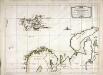
De custen van Noorwegen, Finmarken, Laplandt, Spitsbergen, Ian Maÿen Eÿlandt, Yslandt, als mede Hitlandt, en een gedeelte van Schotlandt
1 Karte : Kupferdruck ; 44 x 54 cm Doncker bÿ Hendrick Doncker boeckverkoper in de Nieubrugsteeg
Vorstellvng der Sonnen- oder Erd, Finsternis den 25. Jul. 1748
Mollova mapová sbírka Lowitz, Georg Moriz Dorn, Sebastian Homann, Johann Baptista - dědici
Europa befolkningskarta
Nouvelle carte des isles de Spizbergue et des environs
1 Karte : Kupferdruck ; 40 x 55 cm Engel; Holzhalb Franz Samuel Fetscherin
Pascaart vande Zee-Custen Van Finmarcken, Laplant, Ruslant, Nova Zembla en Spitsbergen [...] [Karte], in: Het vijfde Deel Des Grooten Atlas : Vervatende De Water-Weereld, S. 119.
1 Karte aus Atlas Jansson, Jan Jansson, Jan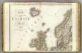
Europe 1.
1 : 3850000 Brue, Adrien Hubert, 1786-1832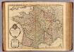
France.
1 : 2100000 L'Isle, Guillaume de, 1675-1726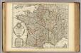
Carte de France.
1 : 2100000 L'Isle, Guillaume de, 1675-1726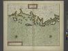
The Chart of FINMARCK from Sanien to North-Kyn or North point
from The sea-atlas : containing an hydrographical description of most of the sea-coasts of the known parts of the world.
Pascaart Vande Zee-Custen van Finnmarcken, Laplant, Ruslant, Nova Zembla en Spitzsbergen [...] Tabula Hydrographica [...] [Karte], in: Novus atlas absolutissimus, Bd. 9, S. 160.
1 Karte aus Atlas Janssonius Offizin


