Maps of Norway

Museumskart 178: Sjøkart over Norskehavet
1 : 1000000
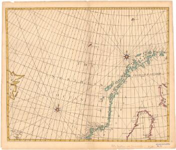
The Chart of FINMARCK from Sanien to North-Kyn or North point
from The sea-atlas : containing an hydrographical description of most of the sea-coasts of the known parts of the world.
Schweden Daenemarck u. Norwegen
Dánsko Mollo, Tranquillo Tranquillo Mollo
Carte d'Europe ou sont tracées les limites des empires, royaumes, et etats souverains, feuille 1
1 Blatt : 63 x 96 cm Semen etc
Northern Europe. Pergamon World Atlas.
1 : 5000000 Polish Army Topography Service
Schweden, Norwegen, Daenemark.
1 : 4000000 Ziegler, J. M.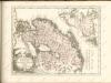

Charte von Schweden und Norwegen
1 : 3700000
Spesielle kart 77: Bathymetrical and hypsometrical map of Norway
1 : 2400000 Kristiania Lithografiske Aktiebolag

[Ethnographische Karte von Europa]
Zweiter Band, enthaltend in vier Abtheilungen die Vertheilung der Organismen: 5. Pflanzen-Geographie, 6. Thier-Geographie, 7. Anthropographie, 8. Ethnographie Humboldt, Alexander von Verlag von Justus Perthes
Spesielle kart 129-3: Oversigtskart over fà ̧rste ordens trianguleringen og præcisionsnivellementet
1 : 2800000
Golfe de Botnie.
1 : 3700000 Vincent
Karte von dem Koenigreiche Daenemark
1 : 980000 Dánsko Reilly, Franz Johann Josef von Müller, Franz Franz Ioh. Ios. von Reilly
Karte von dem Koenigreiche Norwegen
1 : 1500000 Norsko Reilly, Franz Johann Josef von Stöber, Joseph Franz Ioh. Ios. von Reilly
Ost-Europa In 6 Blattern, Enthaltend: Norwegen, Schweden, Russland, Kaukasien Und Die Turkei .
1 : 3700000 Petermann, A.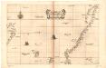
Museumskart 17 Kart over Norskehavet med Island, Færøyene, Shetland og norskekysten
1 : 500000 Robert Dudley
Statistikk 9- Norvege. Mouvement de la population
1 : 2400000
Statistikk kart 12-a: Norvège. Division administrative
1 : 2400000
Spesielle kart 129-4: Bilag nr 3 til opmaalingens budgetforslag for 1915-1916
1 : 2800000
Spesielle kart 66-4: Kart udvisende de med bidrag af Statskassen understøttende Dampskibsrouter
1 : 2400000
Spesielle kart 66-5: Kart udvisende de med bidrag af Statskassen understøttende Dampskibsrouter
1 : 2400000
Spesielle kart 72b: Kart over Valgmands- og Stortingsvalgene
1 : 2400000 K. Petersen Olaf Norli's forlag; Kristiania
Spesielle kart 66-7: Kart udvisende de med bidrag af Statskassen understøttende Dampskibsrouter
1 : 2400000
Statistikk 26-8c: Gjeder. Middeltal pr. Gaard
1 : 2400000
Statistikk kart 22: Tonnage de navires 1873
1 : 2400000
Statistikk kart 19-5: Fremstilling af Norges Agerbrug. Potetsavlen. Udsæd beregnet pr 1000 maal ager
1 : 2400000
Statistikk kart 20- Fremstilling af den Norske Fædrift. Hesten. Dyrenes antal pr. 1000 Maal afhøstet areal
1 : 2400000
Statistikk kart 19- Fremstilling af Norges Agerbrug. Udsæden af Korn i Tønder pr. 1000 maal ager
1 : 2400000